Introduction
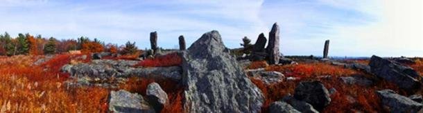
Last year I started series called Poking Paradigms, where I gave my take on historical events in the past that I feel have been distorted to fit the ideological or political ambitions of those who are controlling the narrative. The second WEDA Pokes Paradigms, "Pre-Colombian Standing Stones In New England" focused on the standing stones on top of Burnt Hill in Heath, Massachusetts, which I posted about a year ago.
I have been researching this site for over four years, and I can't explain why really. When I found this site I immediately started to research into who may have erected these standing stones and why? I found nothing. The fact that there seemed to be very little research done is what drove me to figure out all I could about the standing stones on Burnt Hill. I will present my research into Burnt Hill and my theory of who may have erected these stones.
The Evidence
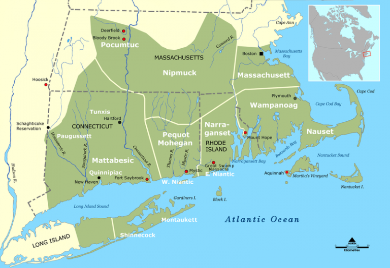
The Pocumtuc people were natives to a wide stretch of land from the Berkshire Mountains to the banks of the Connecticut River. Their territory covered Franklin County, Hampshire County, and Hampden County. Sadly, their population was decimated by smallpox and never-ending wars with the Iroquois and English. After King Philips War it is believed that less than 600 Pocumtuc's survived and traveled to the Mahican village at Schaghticook on the Hudson River in New York. The tribe was scattered but eventually reunited at St. Francois du Lac in Quebec joining the Sokoki Abenaki tribes to the north.
Before the colonizers...
"Like other New England Algonquin, the Pocumtuc were an agricultural people who lived in one of the most fertile farming areas in New England. Their homeland also abounded with game, and during the spring they were able to take advantage of large fish runs up the Connecticut and its tributaries. Besides the obvious north-south transportation provided by the Connecticut River (Quinnitukqut "long river"), the Pocumtuc homeland sat astride several important east-west trade routes, including the Mohawk Trail, which linked Native Americans in the interior with those on the Atlantic coast." (Pocumtuc History)
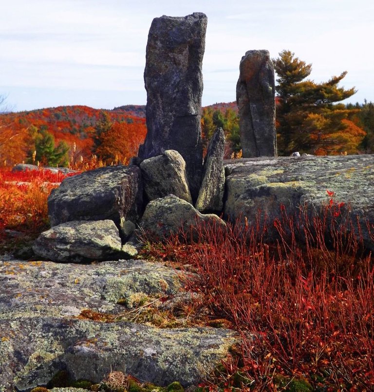
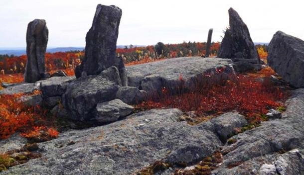
What led me to the Pocumtuc people was historical references Allan Healy in his 1965 "History of Charlemont" states that Burnt Hill was deforested in prehistoric times and that the Pocumtuc's used fire to clear the undergrowth in the hill to help cultivate low bush blueberries. Burnt Hill is still a blueberry farm to this very day. George Sheldon wrote about Burnt Hill in his "History of Deerfield" when he stated that the Pocumtuc Indians called the area Sunsick Hill which translates to "Stone Place" Hill. I found this information by looking through newspaper archives for Heath's local paper the Heath Herald. In 2002 historian Colgate Gilbert did a field study of the Burnt Hill site and some of the information from his site visit was published in the Heath Herald.
While I spent over a year trying to figure out who may have built the Heath site, the answer was right under my nose. Right next to Burnt Hill is Pocumtuc Mountain A little under two miles separates Mount Pocumtuc and Burnt Hill. This gap between the two mountains creates a notch in the horizon, and I will explain why this gap on the horizon has significance to Native Americans of New England.
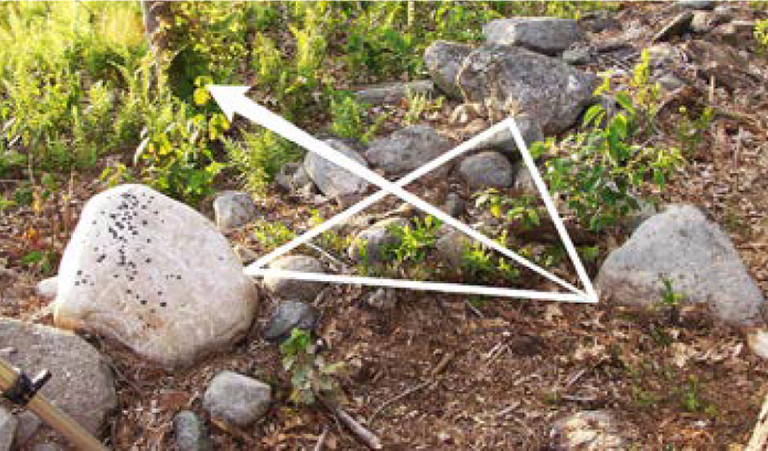
15.5 miles away from Burnt Hill is the Sacred Hill Prayer site in Turners Falls (pictured above), Massachusetts. At the Scared Hill Prayer site stone formation is what archeologist assumed was a broken stone wall, but it is an ancient triangular viewing position those rocks directed ancients natives to look towards Mount Pocumtuc and Burnt Hill. If you stand at this precise location on August 12-13th and look towards the horizon, the sun perfectly sets in the notch on the horizon in the gap between Burnt Hill and Pocumtuc Mountain as it also did in ancient times. (Tribal Historic Preservation Program Annual Report 2017)
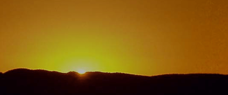
The sunset on August 12-13th is a calendrical indicator of the highest concentration of the month-long Perseid Meteor Shower. For many indigenous people of New England, this event represents the travel of spirits of the deceased home of the Kautantowitt (Creator.) I plan to record this event as it happens in August of this year. This month has significance to Native Americans, the neighboring Narragansetts of Rhode Island host a festival during this time that was first documented 350 years ago.
The Heath site sits on private property which has hindered proper research into the Burnt Hill standing stones. The landowners agreed to allow me to fly my drone over the site and the New England Antiquity Research Association will help in creating a 3-D map of the Burnt Hill standing stones, which I am very excited about. Although I am disappointed that the Burnt Hill standing stones are not open to the public it is important that the property owner's privacy is respected and that their crop is protected because it is their livelihood. I hope the planned field studies and the research I have done on Burnt Hill will lay the foundation for other researchers, archaeologists, historians, or anyone interested in Pre-Columbian America to research this site further.
By Joziah Thayer
Site Visit by David Boudillion 2001: http://www.boudillion.com/burnthill/burnthill.html
The Herald: both articles are on page 3 continued to page 15
The Heath Herald: Part1 pg. 3-15 https://heathherald.org/uploads/3/4/6/3/34634026/vol_22-3_augsep_2001-compressed.pdf
The Heath Herald: Part 2 pg. 3-15 https://heathherald.org/uploads/3/4/6/3/34634026/vol_22-4_octnov_2001-compressed.pdf
Source for the Sun image, the triangle viewing stone image, and information about the Perseid Meteor Shower :
Tribal Historic Preservation Program Annual Report 2017