This creation is pretty interesting and gives us a clearer perspective on what geographical knowledge people had in the last centuries. In 16th century Italy, Monte managed to create an accurate world map including places he’s never been to. This shows us the skills some people had as inventors and makes us realize that humans have always been creating marvelous pieces of art throughout the millennia.
Who was Urbano Monte?
Not much information is available about Monte. What we know is that he was born on 16 August, 1544, he lived in Milan and died on 15 May, 1613. Some examples of his maps have survived to this day.
He contributed to a 4 volume historical diary titled Delle cose piu notabili successe nella citta di Milano, the 4th volume of which describes the visit of the Japanese Embassy to Europe 1582–1590, in particular their stay in Italy. Monte would certainly have met the party when they visited Milan in 1582, and its presumed that the form of Japan depicted in this map stems from information provided by the Embassy.
Monte’s principal fame rests with his geographical treatise Trattato Universale descrittione et sito de tutta la terra sin qui consociuta descritto da Urbano Monte, which accompanies the 60 sheet manuscript map in the Ambrosiano and would have been the first and second book to this volume; probably this was a separate folio volume of text to describe and relate the history and geography of the world.
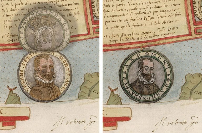
A particular point of interest is the small roundel portrait drawn under the dedication. The atlas has the feel of a work in progress, particularly because of the marginal annotations by Monte and the variety of papers used in its composition. Also, the make up of the atlas — particularly the non-sequential numbering of the earlier sheets, the wear to sheet 7 before binding, and the 17th century binding and guards — suggests that although in some form of binding from the late 16th century, it was reassembled in the present binding and form in mid or early 17th century. The geography of this map is essentially Mercatorial, using Mercator’s world map of 1569 as the style guide.
Technical details of the Planisphere map
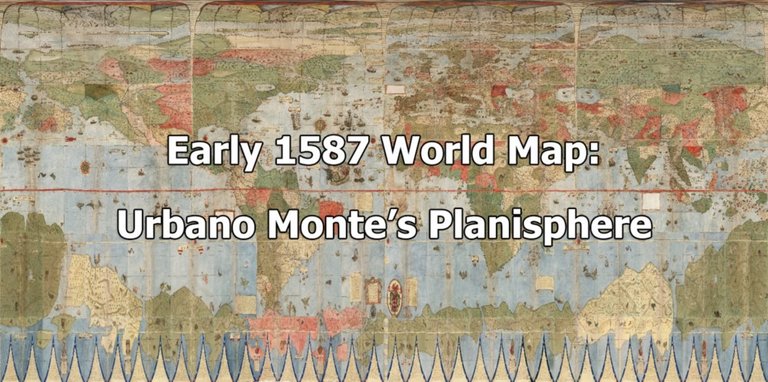
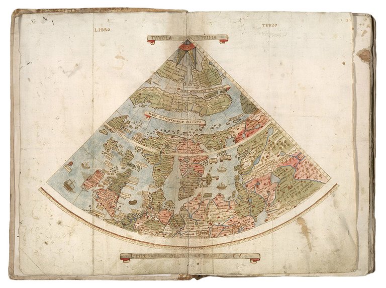
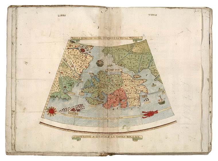
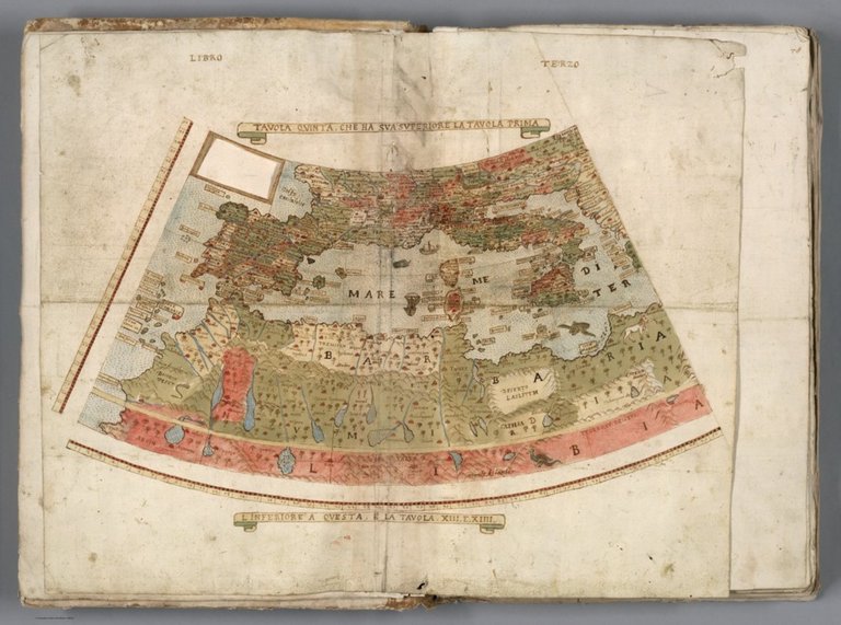
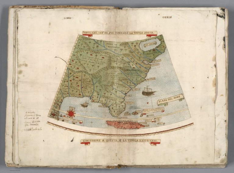
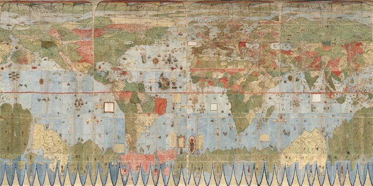
This extraordinary 60 sheet manuscript world map or planisphere is the largest known early map of the world. It was hand drawn by Monte in Milan, Italy, and only one other manuscript copy exists. The digitally joined 60 sheet map image above is the first time the map Monte made has been seen as one unified map — as Monte intended — in the 430 years since it was created.
Whilst unusual, the idea of a North Polar projection does have precedents in cartography, notably the beautiful world map of Postel first published in Paris in 1581, and one to be found engraved in ivory on a table top by Gennaro Picicaro, thought to be Naples, 1597 and probably borrowing from the ideas of Monte. The ideas for the projection can also be seen in the Contarini/Roselli map (Venice: 1506), the Ruysch map (Rome: 1507), and the Fine in Paris in 1531. All were attempts to capture the full extent of the world, in which much was still unknown.
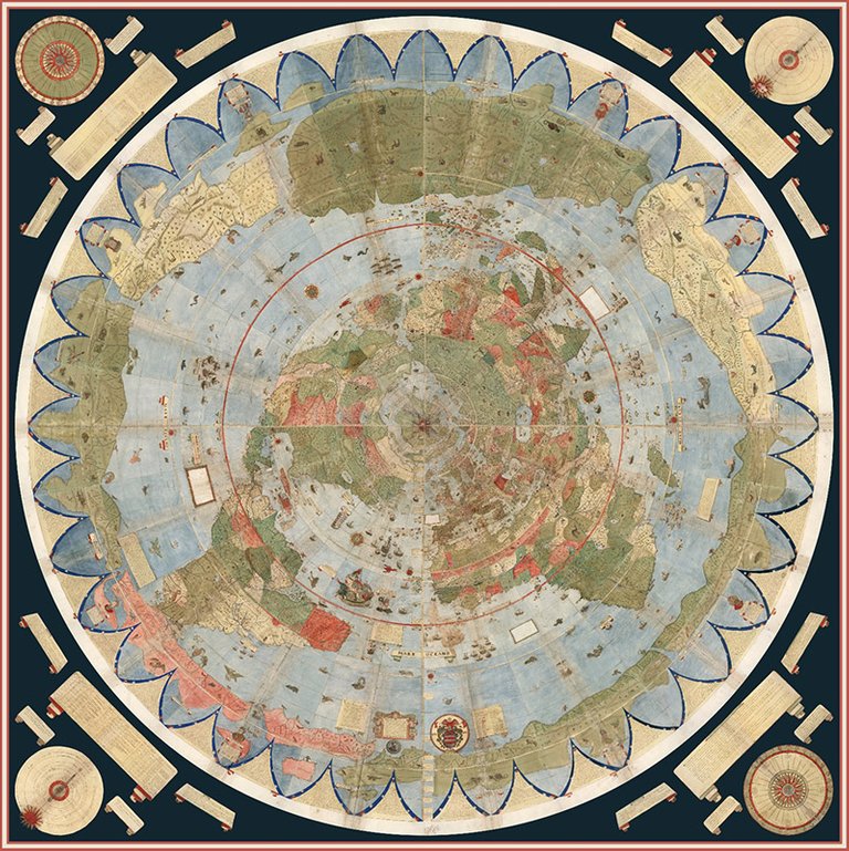
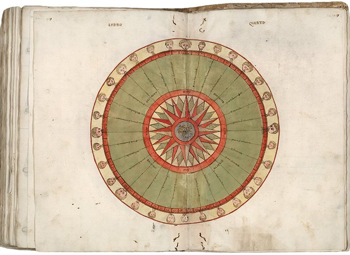
Of great interest is the attempt Monte makes to make his map not just a geographical tool but to show climate, customs, length of day, distances within regions — in other words, to create a universal scientific planisphere. In his dedication on Tavola XL he specifies how to arrange the sheets of the planisphere and makes it explicit that the whole map was to be stuck on a wooden panel 5 and a half brachia square (about ten feet) so that it could be revolved around a central pivot or pin through the north pole.
This was never done, but now we can do it virtually — Monte’s 60 sheet world map digitally assembled into a 10 foot planisphere. Monte’s wall map comes at a time when the map mural had been gaining popularity in Italian decoration. Indeed, a treatise in 1510 by Paolo Cortese describes the appropriate decoration for a Cardinal’s room as “a learned enjoyment of a picture representing the world”.
An important and extraordinary manuscript world map drawn up on a north polar projection to form the largest manuscript map of the world at 10 by 10 feet. This map is one of 3 examples extant (2 manuscripts, 1 printed) that form the continuum of Urbano Monte’s work on his ultimate world map. The other two examples were studied at length by Almagia: manuscript copy S is at the Bibliotheca Seminario Arcivisovale at Venegano near Milan and is similar to this example with the map in 60 sheets.
A second example, printed copy A, is at the Bibliotheca Ambrosiana in Milan, with the frontispiece dated 1590 and the map divided in 64 sheets making the division lines of the sheets easier to arrange. This printed version was published in 1604 on 64 plates, and is the only printed copy known. Two other single sheet engraved world maps by Monte in North Polar projection are also known, published in Milan in 1603 and 1604, copies of both to be found in the Ambrosiana; an example of the 1603 is also in the Doria atlas from the Wardington Collection.
Why is the map important?
Monte’s map reminds us of why historical maps are so important as primary resources: the north polar azimuthal projection of his planisphere uses the advanced scientific ideas of his time; the artistry in drawing and decorating the map embodies design at the highest level; and the view of the world then gives us a deep historical resource with the listing of places, the shape of spaces, and the commentary interwoven into the map. Science, art, and history all in one document.
Until now, Monte’s manuscript map was seen as a series of 60 individual sheets. The only assembled version is the small single key sheet of the series. Now that they have joined all 60 sheets digitally (accomplished with great skill by Brandon Rumsey), we can appreciate in a new way the extraordinary accomplishment that Monte made. The assembled map, just over 10 feet in diameter, is one of the largest — if not the largest — world maps made in the 16th century. The degree of detail and decoration is stunning and the entire production is surely unique in the history of cartographic representation.
On tavola XXV, Monte claims his sources for the map, citing geographers Piccolomini, Pliny, Ptolemy, Cortes, Fernando Columbus, Juan Gonzalez de Mendoza, Giovanni d’Anania, various Jesuit letters, including Marco Polo, and cartographers Mercator, Gastaldi, Olaus Magnus, Giovio, Lopes and the brothers Zeno.
Between 1560 and 1580 four of the greatest map murals had been executed: fresco maps in Palazzo Vechia, Florence, two in the Vatican and another in Palazzo Farrnese in Caprarola. Almost certainly Monte had envisioned his opus as gracing the walls of a Ducal Palace in Milan, and the engraving of the 1590 sheets to make a printed wall map indicates that he had planned to distribute his geography to a wider audience. A monumental map, this little known work by Monte can take its place alongside Mercator, Waldseemueller, Gastaldi and other greats of 16th century world mapping.
Google Earth
The 60 manuscripts were digitally put together and are available to watch on a globe. You can also click here, to download the KMZ File and open it in Google Earth — Requires download of Google Earth here.
Urbano Monte’s 1587 map of the Planisphere is owned by the map collector David Rumsey, whose entire collection is available online for viewing on his website. Full resolution images of the Monte map, available here: Urbano Monte's Planisphere.
The David Rumsey map collection

David Rumsey is an American map collector and the founder of the David Rumsey Map Collection. He is also the president of Cartography Associates. Rumsey has a Bachelor of Arts and a Master of Fine Arts from Yale University and was a founding member of Yale Research Associates in the Arts. He was also a 1966 initiate into the Skull and Bones Society.
Rumsey has collected from the early 1980s more than 150,000 rare 16th through 21st century maps of North America, South America, Europe, Asia, Africa, Pacific, Arctic, Antarctic, and the World. The collection includes separate maps, atlases, globes, school geographies, books of travel and exploration, and maritime charts. Currently the online web site has over 30,000 high resolution images of maps from his collection. The site is free to the public and is updated monthly.
The entire collection is now hosted in the David Rumsey Map Center that opened on April 19, 2016 in the Bing Wing of Green Library, Stanford University. The Center contains rare maps and atlases in addition to interactive, high-resolution screens for viewing digital cartography. The David Rumsey website continues as a separate public resource.

This article was originally posted on: https://www.crypto-world.gr/earthchronicles/the-earth-chronicles-1-the-world-map-by-urbano-monte-in-1587/
Wow! Very interesting and well written! Thanks for sharing! Bookmarked your article to share with friends! Very nice!
Cheers!
Lucky
Thank you. 👍