What's buzzin Hive!
I figured I should probably write something at some point, at least if I get started, it might motivate me to finish 🤣 ! We are currently on lockdown until after the new year but I still have the details of our Jasper trip to get thru, we slipped that last minute trip in just in time so it seems! Before we get to that, I want to thank the team of @pinmapple and the #haveyoubeenhere community along with the prize contributors for selecting my entry for the 1000 post celebration series of contests, it was a nice birthday/Christmas surprise to wake up to that will get me closer to my dolphin goal (I can almost taste it...took a lot of writing to get here!
.jpg)
.jpg)
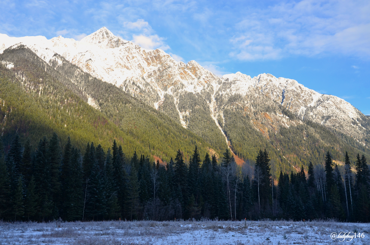
We went to Jasper about mid November, so about a month ago. We generally go a week earlier because this is our anniversary trip but we were just coming back from Banff for what was a lay-off mountain trip and wanted to cool our jets and let our muscle relax between hikes since we are both getting old. We saw the covid numbers begin to rise again and the writing was on the wall, I knew skipping out of town was a limited time offer shorter than a black friday sale (although this year they were like 2 weeks long here).
As per usual, we stayed at the less scenic but much cheaper near-by town of Hinton for around $85 per night. It's still semi-sorta in the mountains but it smells like pulp mill (because there is one)...eww...that's also probably where I would work if I were to move there...double eww...But it's 20 minutes drive from Jasper National Park and I assure you, that is quite the backyard! After our week of horrors at the (not) Quality Inn from our last visit in January, we decided to go for a super-chain like Best Western where we knew exactly what to expect for about the same price. Continental breakfast was a let down because of covid and food sharing precautions otherwise it was the pretty standard experience.
.jpg)
https://hive.blog/travel/@ladybug146/canadian-rockies-the-mount-robson-of-my-dreams
One year for our anniversary trip, we went to Mount Robson and hiked to Kinney Lake just outside of Jasper on the British-Columbia side and it looked spectacular. I was hoping to go back to an unfrozen lake but suspected I may be a little to late for that. The forecast looked pretty grubby for this area for the rest of the week except for one overcast day being our first here. We didn't get to leave as early as we wished, we still had a bit of a drive there since Mount Robson is completely on the other side of Jasper and it's one beautiful slow road to get to especially with snow on the ground but we would also be traveling slightly back in time as we were crossing a time zone plus having been on this trail enough times to be comfortable enough to return safely in the dark, it didn't really matter too much.
.jpg)
We got here at around 10 am and it was still pretty cloudy but we could see some blue sky here and there with some sun, the temperature would stay at around the freezing mark for the day. Bring your own food and water for the day because this time of year, the visitor center is closed and there is nothing between Jasper and Valemount. Full tank of gas, a first aid kit and blankets in case you get stuck for a bit, it's on a major highway but still a narrow mountain pass but we will come back to that later. Warm clothing in layers since it's nice in the woods but cold and windy around the lake. Proper traction like cleats are not an absolute but very helpful since this time of year the trail in more like un-packed snow than ice, hiking poles also helpful especially to go around the lake.
.jpg)
The trail we will get into is part of the famous 42 km (return) multi day hike Berg Lake Trail leading to...you guessed it...Berg Lake...but we will only be doing a small portion today. The trail head begins past the visitor center all the way down to the loop parking, it's the end of the road so you can't miss it. Permits and orientation are required to spend the night on the mountain but for day hikes, it's open to anyone. Don't let it's provincial park status fool you, this is an astonishing area to visit and an official UNESCO heritage site , just as beautiful as Jasper National Park and there is no shortage of trails, lakes, waterfalls topped with a 800m (2600ft) glacier to discover. I don't spend nearly as much time as I would like since we tend to take our summer trips to trails that close for winter. Even doing a portion of the hike is impressive.
.jpg)
.jpg)
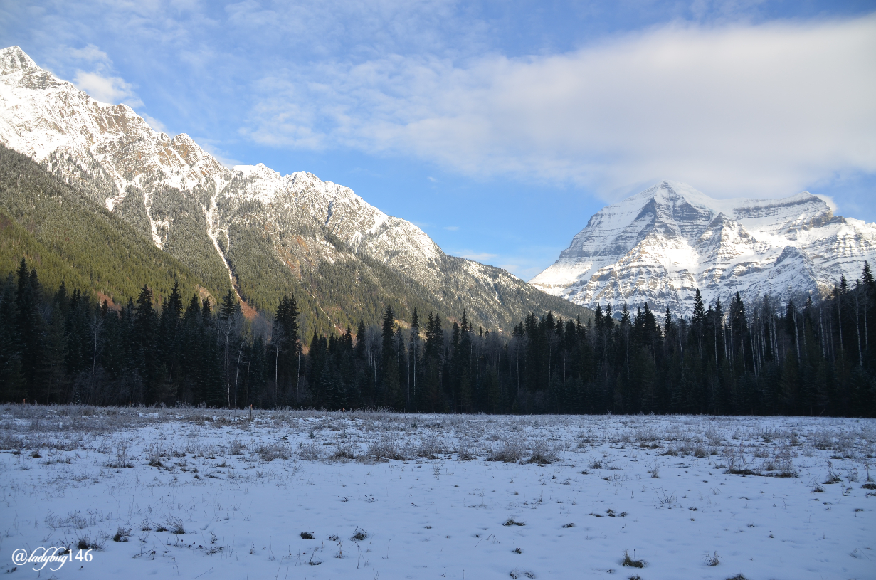
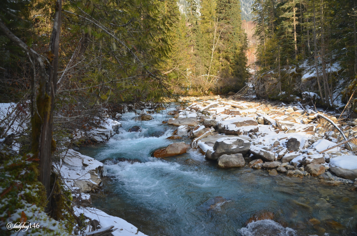
Although not the tallest mountain in Canada, because it already sits at high altitude, Mount Robson is the highest point of Canada and the northern Rockies. The Berg Lake trail begins on Cinnamon Peak for an easier hike until Kinney Lake with mild elevation gain once at the first lake is actually the base of Mount Robson with a prominence of 2819 meters(9249 ft) for a total of 3954 meters (12,972ft) above sea level. The trail is wide and manicured in the summer but a bit rough and snowy this time of year following the Robson River upstream for most of the way. The river is shallow but it's not frozen, it's much higher in the summer when glaciers melt.
.jpg)
.jpg)
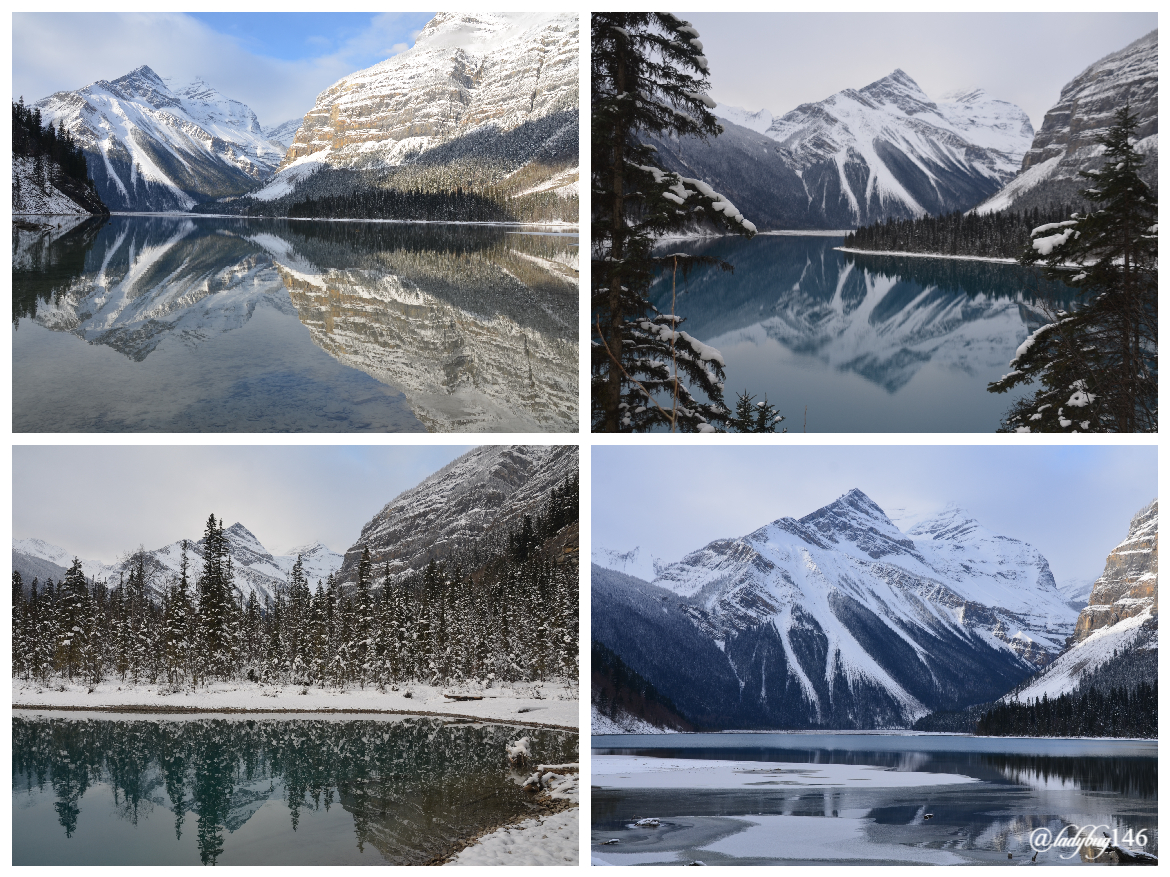
Kinney Lake is a lake that shouldn't be but nature decided to put one there anyway. The Robson river flows carrying the melting glacier water but a sandbar eventually formed causing a natural dam intercepting the river and substantially slowed the flow causing the water to pool up and form a lake otherwise the Robson river would probably be mighty fierce! The Robson river flows into British-Columbia's iconic Fraser River. The hike to the lake is a little over 2 km (4.5 return) with a minimal elevation with only 150 meters gained, suitable for most with only one steep-ish hill (it's not that bad). Most of the hike is sheltered from the elements nestled in the tall redwood cedars.
.jpg)
.jpg)
.jpg)
.jpg)
There is a bridge to cross the natural dam but the lake is shortly after, right behind the trees. From a distance, looks like we were probably looking at a mostly frozen lake as I suspected. There were a few spots with open water but minimal. It was windy erasing any reflection that would try to form on what was left for open water, for a quick second I got my wish...sort of. The temperature was beautiful but the overcast was ruining my photography party. This place is amazing and all but part of me felt a little letdown since I must have been here at the perfect time last trip and had my expectations set pretty high, turns out it was more beginner's luck and the landscape would be shy for me today. I really have to make it up here in early fall or summer afternoon.
.jpg)
.jpg)
.jpg)
Of course we didn't stop here, up ahead, there is a viewpoint with a nice vantage view but it will cost you a few switchbacks to get to. Our plan for the day was to continue as far as daylight allowed us but to be realistic, slightly passed the first backcountry campground to the back of the lake where the river flows in. In the distance, it appeared like part of the lake wasn't frozen yet towards the back. Turns out it was nothing but an optical illusion. The thin ice was still clear being less than a half an inch thick, it was hard to tell but we started throwing stuff at it and they didn't sink so...not water...lol. As the rocks slid across the ice they made the ice vibrate and sing this high pitch space-like noise almost like a light saber. We might of had way too much fun with that one. We were alone anyway, we met a total of 3 people today and 2 of them were on their way out.
.jpg)
.jpg)
.jpg)
We did eventually reach the back of the lake and brrr it's cold and windy here! We crossed the rocky terrain where the river normally flows all the way to what's left for the winter river but most of it was dried out. I did come across a patch of open water and a good view of where the ice begins to show you how clear the ice is but not for long. By now (december) it must be covered in snow. We didn't stick around here too long, I was turning into an icicle flapping in the wind like one of those used cars flailing arms thingy...It was getting late anyway and still had to make our way back. The walk around the lake has one steep switchback section at the beginning, the rest is mild up and down all the way to the campground. Now that there is less water in the lake, it looks creepy how fast it gets deep when looking in, about 3 feet in it looks like neck high water.
.jpg)
.jpg)
For a small history lesson, Mount Robson was named after Hudson Bay Company explorer/fur trader Colin Robertson but the first mention of the location was found in other fur trader diaries in 1827 as Mount Robinson but over time and mispronunciation the name evolved. George Kinney and Donald "Curly" Phillips were the first recorded to conquer the peak in 1909. In Alberta, we call our portion of the Trans-Canada highway the "Yellowhead Trail" because of this section of land. Mount Robson overlooks the Yellowhead Pass, an important goods transportation corridor and much of the local history and settlements is centered around the railroad that unified Canada in the early days as one of the conditions for B-C to sign on to the Confederation. Local nomadic Indigenous Texqakallt tribes called it “Yuh-hai-has-kuy” which means “Mountain Of The Spiral Road.”
We just spent the afternoon here but for someone interested in spending most of their vacation in this location, there is a near-by village of Valemount equipped with affordably priced cabins. Snowmobiling isn't allowed in the provincial park but a popular activity offered in town.
Cheers! X🐞X
Super beautiful!
Thank you! Merry Christmas xox
Congratulations, your post has been added to Pinmapple! 🎉🥳🍍
Did you know you have your own profile map?
And every post has their own map too!
Want to have your post on the map too?
Wow, amazing just amazing. Thanks for sharing your amazing work with us.
Thank you for the kind words! Merry Christmas!
Thanks, Merry Christmas to you and yours too.
$tangent
Congratulations, @minnowspower You Successfully Trended The Post Shared By @ladybug146.
You Utilized 3/3 Daily Summon Bot Calls.
TAN Current Market Price : 1.860 HIVE
😱 TERRIFIC landscape! Superb shots! 💪
Thank you! Merry Christmas!
Another stunning post as always @ladybug146. You really know how to capture Canada's beautiful spots.
Thank you, that is very sweet of you! I'm always happy to find the hidden gems of the landscape. Merry Christmas xox
Hiya, @choogirl here, just swinging by to let you know that this post made it into our Top 3 in Daily Travel Digest #1062.
Your post has been manually curated by the @pinmapple team. If you like what we're doing, please drop by to check out all the rest of today's great posts and consider supporting other authors like yourself and us so we can keep the project going!
Become part of our travel community:
Thank you!
Looks like Admiral Byrd has some competition when it comes to Arctic exploration. Not exactly the Arctic but as far as I can see close enough! I really liked the picture of the small waterfall with the icicles hanging from the log.
Nice job with this post!
Dolphin, you say?
Penny by penny, I say!
Penny by penny bro, it's actually happening! Imma gonna be an empire soon, I think my vote is up to .03 now! lol
A new explorer for me to read up on later, thanks, I don't know where you get them from but you sure know how to make me smarter one explorer at a time😁. Merry Christmas to you and your family from the great white north!! 🥰
Joyeux Noël!
Congratulations @ladybug146, You Earned 0.618 TAN & Curators Made 0.432 TAN.
Join CORE / VAULT Token Discord Channel or Trade TANGENT Token
TAN Current Market Price : 1.930 HIVE
Beautiful photos. The lighting was even working in your favor. That looks like an amazing place to do some exploring. It would be fun to do some astrophotography there, but probably pretty chilly...
Oh yeah it's pretty cold there especially around the lake but yes beautiful spot for watching the night skies, the trail back is fairly straight forward from the lake. There is a lot to explore in the area, this is just a small slice.
Hi dear i just came by to wish you merry christmas and a prospor 2021
Thank you! Merry Christmas and happy New Year! To 2021!