Welcome to Part 2 of our recent travels in the South of France. In case you missed it, Part 1 can be found here. In Part 1, I wrote about the sources of the river Loire and a stunning replica of a cave with amazing prehistoric paintings.
In today's second and last installment, we tour the majestic canyons of the Ardèche river, look at a famous Roman aqueduct from antiquity, make a quick stop in the charming city of Arles and on the coast, visit the medieval village of Gordes, and clear up why that darn lavender isn't purple. Let's get crackin'!
Willkommen zu Teil 2 unserer jüngsten Reise durch Südfrankreich. Falls Du ihn verpasst hast, findest Du Teil 1 hier. In Teil 1 habe ich über die Quellen der Loire und eine beeindruckende Nachbildung einer Höhle mit erstaunlichen prähistorischen Malereien geschrieben.
Im zweiten und letzten Teil besichtigen wir die majestätischen Schluchten der Ardèche, schauen uns ein berühmtes römisches Aquädukt aus der Antike an, legen einen kurzen Stop in der charmanten Stadt Arles und an der Küste ein, besuchen das mittelalterliche Dorf Gordes und klären, warum der verdammte Lavendel nicht lila ist. Auf geht's!
 Click here to watch an entertaining 20-minute video of the whole trip.
Klicke hier für ein unterhaltsames 20-minütiges Video der ganzen Tour.
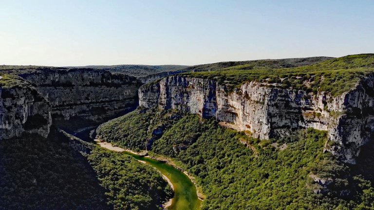
The European Grand Canyon
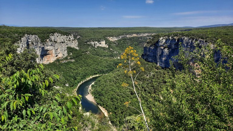
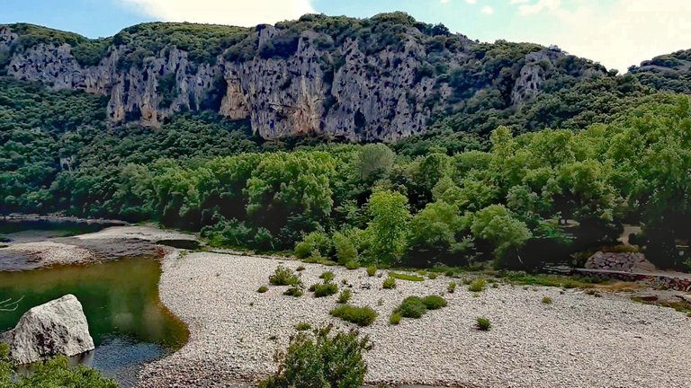
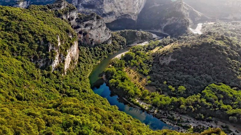
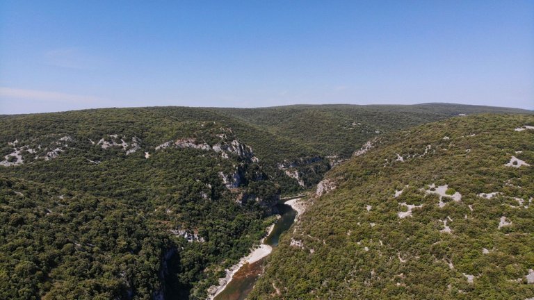
In the French Département Ardèche, between the towns of Vallon-Pont-d'Arc and Saint-Martin-d'Ardèche, the river Ardèche has carved out some thirty kilometers (20 miles) of canyon which is a marvelous sight to behold! The canyon is a prime tourist attraction, drawing over a million visitors per year.
Designated "Réserve Naturelle Gorges de l'Ardèche", most of the area is a protected nature preserve. But the canyon also protects itself: much of it is inaccessible except by water, so canoeing and kayaking are popular sports on the river. Other parts can only be reached through rather strenuous hikes.
Although in principle difficult to access, over 2,000 caves are found in the gorge, and humans have settled in the area for over 30,000 years. Thus, some of the caves, like the best-known Chauvet cave, have prehistoric paintings, as I showed in Part 1.
In some caves, you can do your own spelunking as they offer tours to the public. We haven't been there on this trip, but my recommendation would be the Grotte de Saint-Marcel right off the scenic road D290, if you can handle some 500 stairs. Bonus: they do wine tastings, too. ;-)
Grotte de Saint-Marcel. Photo by Getfunky Paris via Wikimedia Commons.
Der europäische Grand Canyon
Im französischen Département Ardèche, zwischen den Städten Vallon-Pont-d'Arc und Saint-Martin-d'Ardèche, hat der Fluss Ardèche einen etwa dreißig Kilometer langen Canyon gegraben, der fantastische Vistas bereithält! Der Canyon ist eine wichtige Touristenattraktion, die jährlich über eine Million Besucher anzieht.
Unter der Bezeichnung "Réserve Naturelle Gorges de l'Ardèche" steht der größte Teil des Gebiets unter Naturschutz. Aber die Schlucht schützt sich auch selbst: Ein großer Teil ist nur auf dem Wasserweg zugänglich, so dass Kanu- und Kajakfahren auf dem Fluss ein beliebter Sport ist. Andere Teile sind nur durch ziemlich anstrengende Wanderungen zu erreichen.
Obwohl sie grundsätzlich schwer zugänglich ist, gibt es in der Schlucht mehr als 2.000 Höhlen, und die Menschen sind seit über 30.000 Jahren in diesem Gebiet ansässig. So weisen einige der Höhlen, wie die bekannteste Chauvet-Höhle, prähistorische Malereien auf, wie ich in Teil 1 bereits ausgeführt habe.
In manchen Höhlen kannst Du deine eigene Höhlenforschung betreiben, da diese Führungen für die Öffentlichkeit anbieten. Wir waren auf dieser Reise selbst nicht dort, aber meine Empfehlung wäre die Grotte de Saint-Marcel (Foto oben) direkt an der Panoramastraße D290, wenn man 500 Stufen bewältigen kann. Bonus: Die bieten auch Weinverkostungen an. ;-)
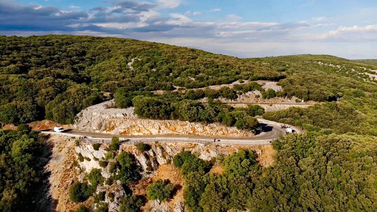
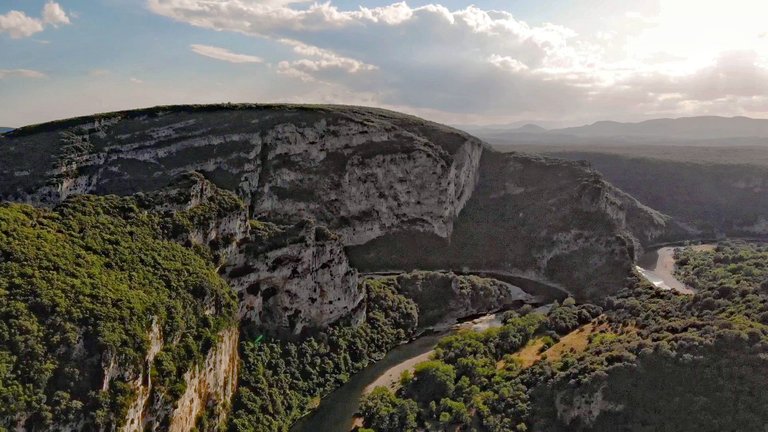
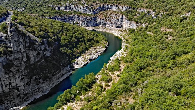
Driving the Corniche
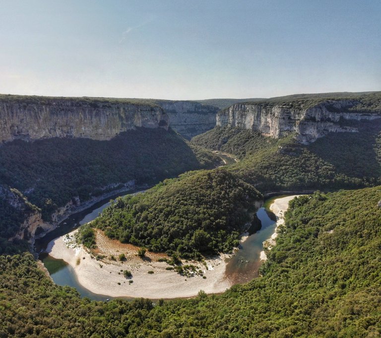
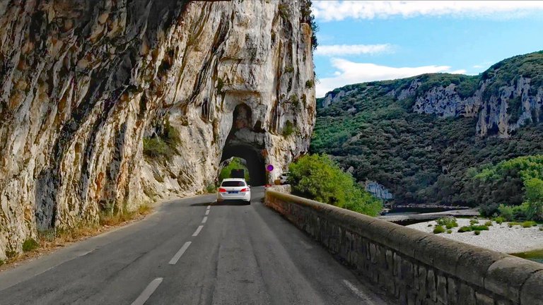
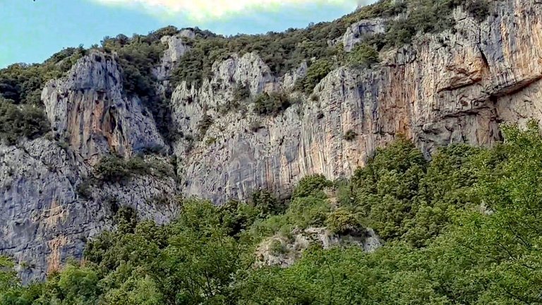
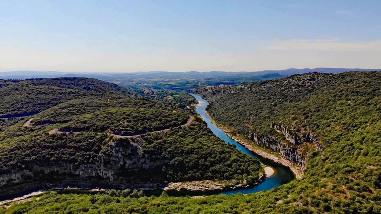
Luckily, for the rest of us who aren't certified athletes, there is a wonderful way to experience the canyon: the scenic road D290, the "Corniche" or "Route des Gorges de l'Ardèche", runs along the northern side of the canyon high up through the scrubland, providing breathtaking panoramic vistas from plenty of safe stops along the roadside and a good number of designated viewing platforms.
Unterwegs auf der Corniche
Zum Glück gibt es für uns anderen, die keine ausgewiesenen Sportler sind, eine wunderbare Möglichkeit, die Schlucht zu erleben: Die Panoramastraße D290, die "Corniche" oder auch "Route des Gorges de l'Ardèche", führt entlang der Nordseite der Schlucht hoch durch die Garrigue und bietet atemberaubende Panoramablicke von zahlreichen sicheren Haltestellen am Straßenrand und einer großen Anzahl ausgewiesener Aussichtsplattformen.
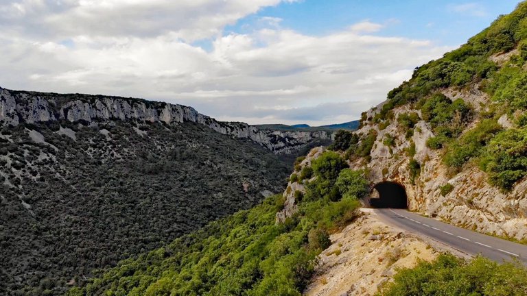
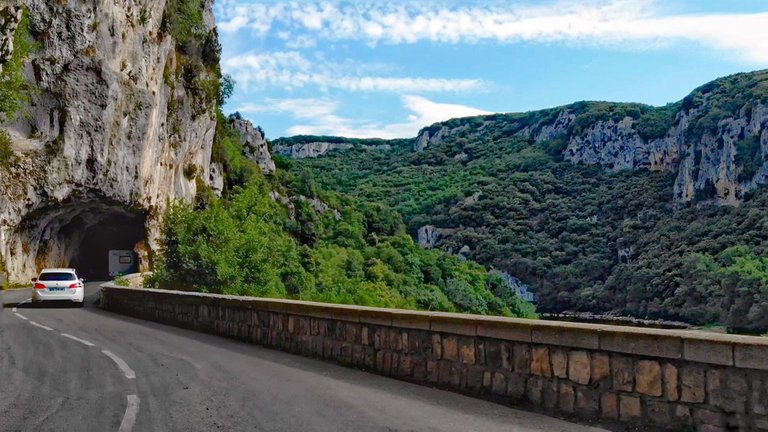
Rather than jibber-jabbering on with facts nobody really cares about, let's look at a few photos of the drive, in the order they were taken. We started in Vallon-Pont-d'Arc, following the brown road signs for "Route des Gorges de l'Ardèche" found all over town. You can't miss it! The road starts out at river level and in time climbs up to slightly dizzying heights.
Anstatt mit Fakten um mich zu werfen, die niemanden wirklich interessieren, sehen wir uns lieber ein paar Fotos von der Fahrt an, in der Reihenfolge, wie sie gemacht wurden. Wir starteten in Vallon-Pont-d'Arc und folgten den braunen Straßenschildern "Route des Gorges de l'Ardèche", die überall in der Stadt zu finden sind. Man kann sie nicht verfehlen! Die Straße beginnt auf der Höhe des Flusses und steigt mit der Zeit in leicht schwindelerregende Höhen an.
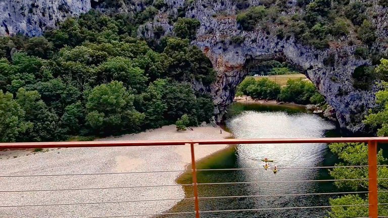
One of the first sights along the way to warrant a stop is the Pont d'Arc, a natural bridge the river carved out of the rock. Unfortunately, I had severe backlight over the top of the arch, which my camera just couldn't handle, so here is a photo from Wikimedia Commons:
Eine der ersten Sehenswürdigkeiten auf dem Weg, für die sich ein Halt rentiert, ist die Pont d'Arc, eine natürliche Brücke, die der Fluss aus dem Felsen gegraben hat. Leider hatte ich extremes Gegenlicht über dem Bogen, was meine Kamera einfach nicht hinbekommen hat, daher hier ein Foto von Wikimedia Commons:
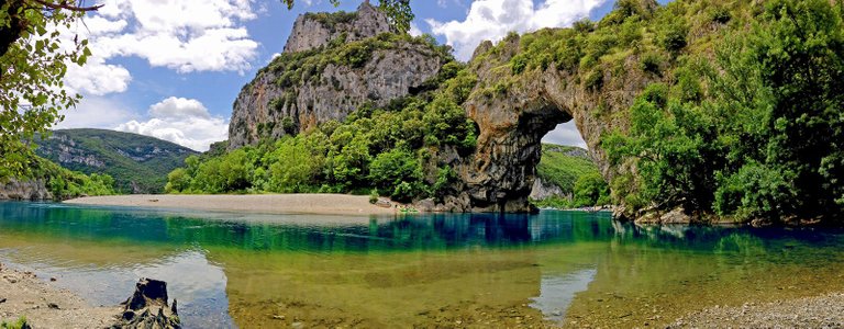
Pont d'Arc. Photo by FotoGrafKoks via Wikimedia Commons.
Up and up we climbed, but daylight was fading fast. Rather than seeing nothing but shadows in the depths of the gorge, we decided to call it quits for the night.
Wir kletterten immer weiter hinauf, aber das Tageslicht schwand schnell. Anstatt in den Tiefen der Schlucht nur noch Schatten zu sehen, beschlossen wir, für die Nacht Schluss zu machen.
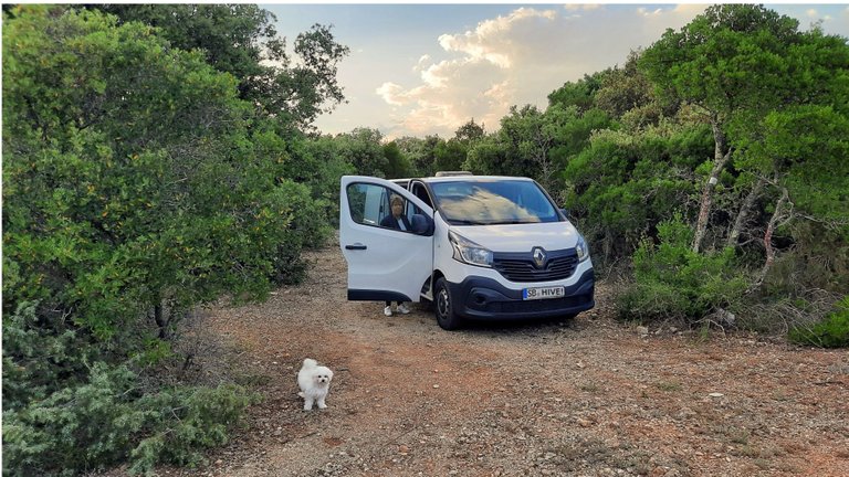
A Quiet Place to Sleep at Nature's Bosom
Near Saint-Remèze, about halfway along the Corniche, I kept noticing small paths off the road into the garrigue. So we headed for the cover of the bushes and were rewarded with a prime camp spot off the main drag, guaranteed not to be caught by a park ranger during the night. ;-)
Here are the coordinates: 44°20'53.1"N 4°28'15.4"E. The site can be approached with panel vans, but not RVs, if you're not afraid to let the bushes polish your paintjob a bit. If you're going to camp there, please don't be an asshole: no open fires and take your trash with you. Don't fuck it up for the rest of us!
Ein ruhiges Plätzchen zum Schlafen am Busen der Natur
In der Nähe von Saint-Remèze, etwa auf der Hälfte der Corniche, fielen mir immer wieder kleine Pfade von der Straße in die Garrigue auf. Wir schlugen uns also buchstäblich in die Büsche und wurden mit einem erstklassigen Platz zum Freistehen abseits der Straße belohnt, an dem garantiert kein Parkranger in der Nacht vorbeikommen würde. ;-)
Hier sind die Koordinaten: 44°20'53.1"N 4°28'15.4"E. Der Platz kann mit Kastenwagen, aber keinen WoMos, angefahren werden, wenn man keine Angst hat, seinen Lack ein bisschen von den Büschen polieren zu lassen. Wenn Du da campen willst, sei bitte kein Arschloch: Kein offenes Feuer und nimm deinen Müll wieder mit. Versau' es nicht für den Rest von uns!
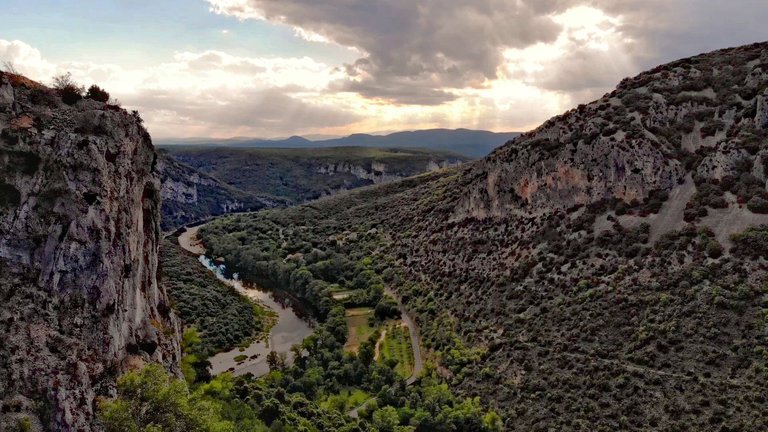
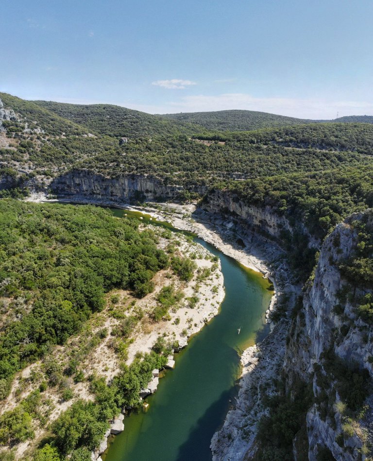
Morning atop Les Gorges des Templiers
The next morning, after the usual morning rituals, we got back on the panoramic road, and within a couple of klicks we were treated to the spectacle of Les Gorges des Templiers, the Canyon of the Templars:
Morgens über den Gorges des Templiers
Am nächsten Morgen ging es nach den üblichen Morgenritualen wieder auf die Panoramastraße, und schon nach wenigen Kilometern bot sich uns das Schauspiel der Gorges des Templiers, der Schlucht der Templer:
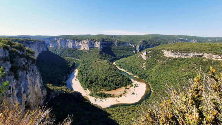
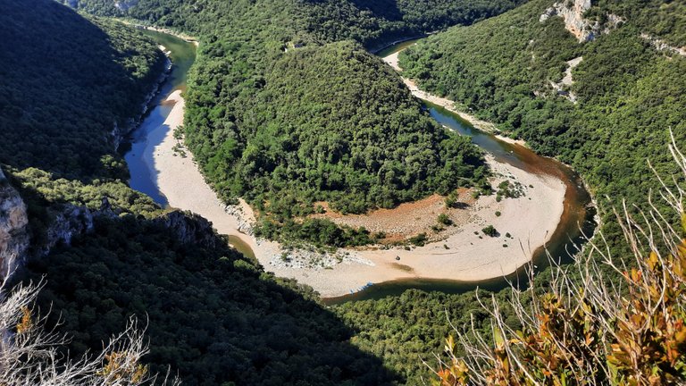
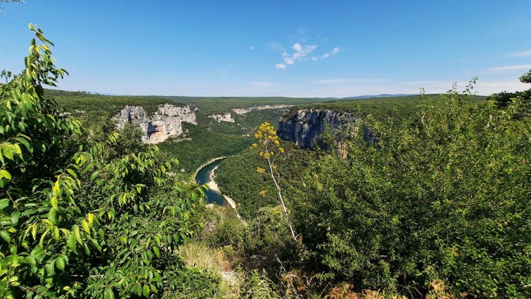
To be honest, all those place names are a little confusing to me. This particular loop in the river appears to be named Cirque de la Madelaine and is a major scenic stop with two purpose-built overlooks. The names don't matter, though, as the road neatly presents one attraction after the other, and one doesn't have to look for them on a map.
If you look closely at these pictures, you can make out ruins in the woods between the entrance and exit of the loop (next photo top middle, following photo top left corner). That's the Monastère de la Madeleine, also called the Maladrerie des Templiers (Templar Infirmary) dating from the 11th century. I can't hike there and drone flying is extremely limited, to put it mildly, so I'm including a photo from Wikimedia Commons further down.
Um ehrlich zu sein, diese ganzen Ortsnamen finde ich ziemlich verwirrend. Diese besondere Flussschleife scheint Cirque de la Madelaine zu heißen und ist ein wichtiger landschaftlicher Halt mit zwei eigens dafür errichteten Aussichtspunkten. Die Namen spielen jedoch keine Rolle, da sich alles entlang der Straße nahtlos aneinander reiht und man nichts auf der Karte suchen muss.
Wer genau hinschaut, kann man im Wald zwischen dem Eingang und dem Ausgang der Schleife eine Ruine erkennen (vorheriges Foto oben in der Mitte, folgendes Foto oben links). Das ist das Monastère de la Madeleine, auch Maladrerie des Templiers (Siechenhaus der Templer) genannt, aus dem 11. Jahrhundert. Ich kann nicht dorthin wandern, und Drohnenflüge sind, vorsichtig ausgedrückt, extrem begrenzt (vulgo verboten), daher füge ich weiter unten ein Foto von Wikimedia Commons ein.
Für den Saarländer ist das der perfekte Ort: Eine "Saarschleife" in der Fremde, samt Burg Montclair im Wald obendrauf. Saarländer und diejenigen, die schon einmal die Saarschleife gesehen haben, werden sofort verstehen, was ich meine. Fast hätt' ich den Schwenker ausgepackt... :-)
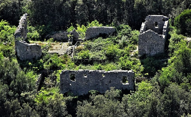 Maladrerie des Templiers. Photo by Celeda via Wikimedia Commons.
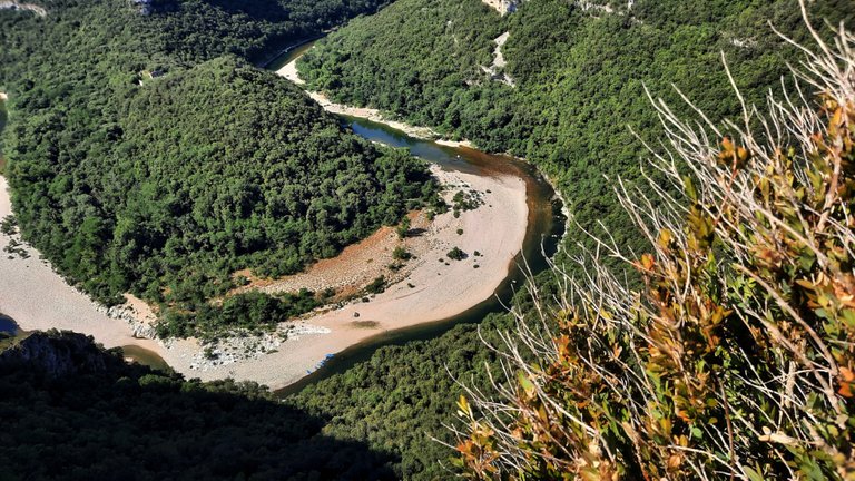
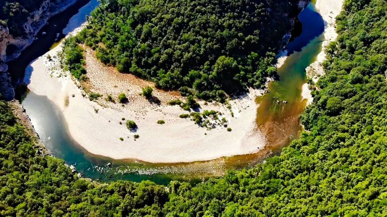
The gorgeous sandy Plage des Templiers (Beach of the Templars) in the glistening sun made me regret not having more time on hand for a canoe trip down the river. Maybe next time...
Der herrliche Plage des Templiers (Strand der Templer) in der gleißenden Sonne ließ mich bedauern, dass wir nicht mehr Zeit für eine Kanupartie auf dem Fluss hatten. Vielleicht beim nächsten Mal...
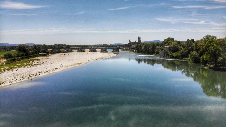
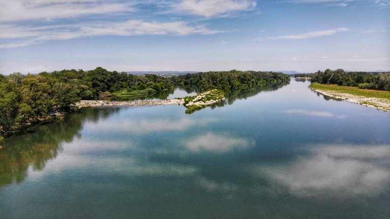
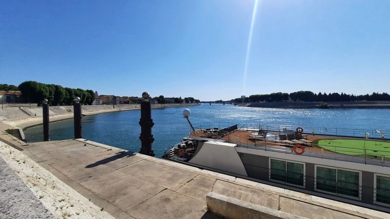
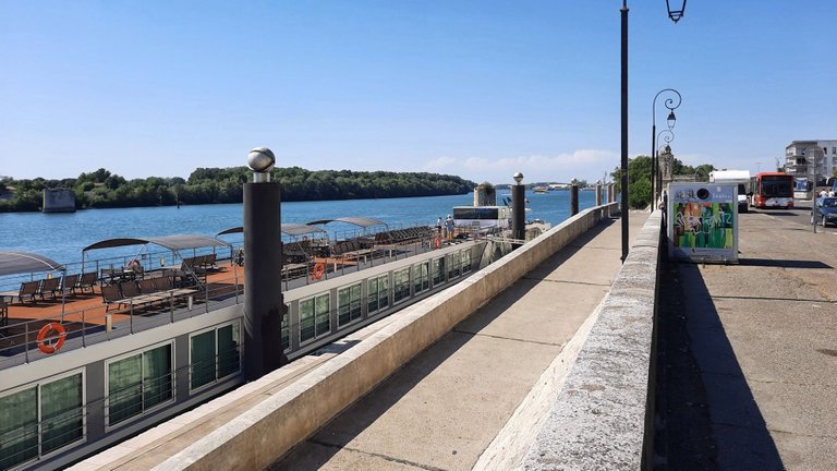
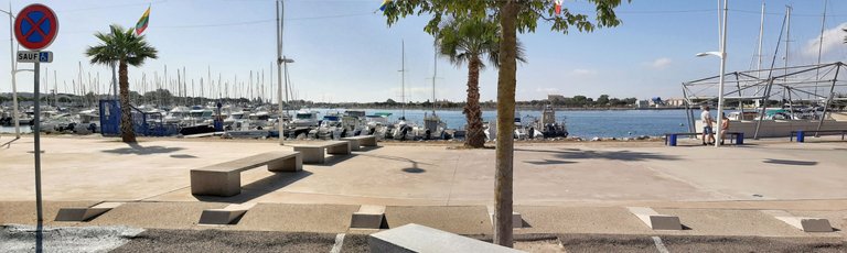
Confluence of Ardèche and Rhône
Practically on our way to our next major attraction lies the little town of Pont-Saint-Esprit. We got a little shopping done and spent our lunch hour under some trees alongside the river Rhône, just below the mouth of the Ardèche (2nd photo left).
Mündung der Ardèche in die Rhône
Praktisch auf dem Weg zu unserer nächsten größeren Attraktion liegt das Städtchen Pont-Saint-Esprit. Wir erledigten ein paar Einkäufe und verbrachten unsere Mittagspause unter Bäumen am Ufer der Rhône, gleich unterhalb der Mündung der Ardèche (2. Foto links).
A Strange Bridge
At our next stop we were suddenly confronted with this mysterious bridge in the distance, in the middle of a desert-like landscape! What might this be? And everything is so dry! One could really use a few gallons of water here. If only there was some kind of water supply... Somebody should build something!
Eine seltsame Brücke
Bei unserem nächsten Stopp sahen wir uns plötzlich in der Ferne mit dieser sonderbaren Brücke inmitten einer wüstenhaften Landschaft konfrontiert! Was das wohl sein mag? Und alles ist so trocken! Man könnte hier wirklich ein paar Liter Wasser gebrauchen. Eine Wasserleitung wäre da echt praktisch... Jemand sollte eine bauen!
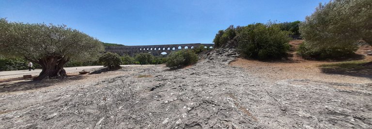
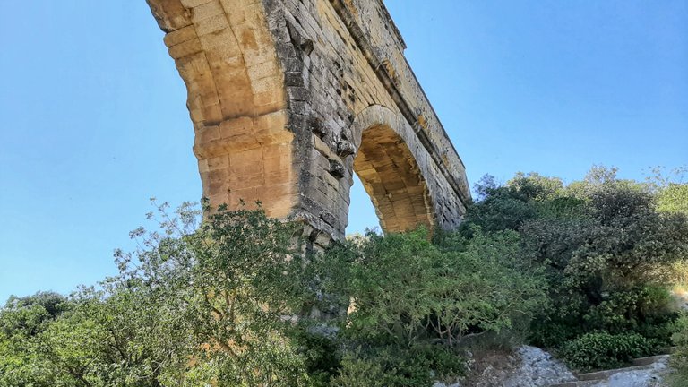
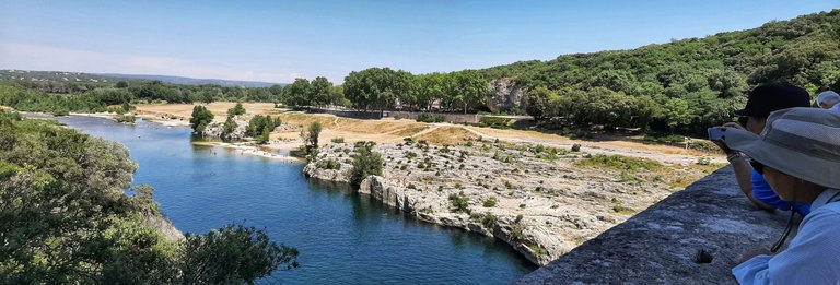
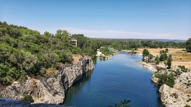
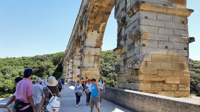
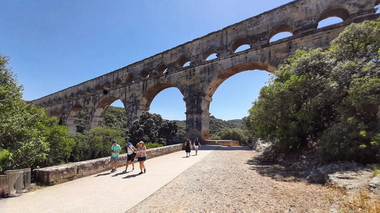
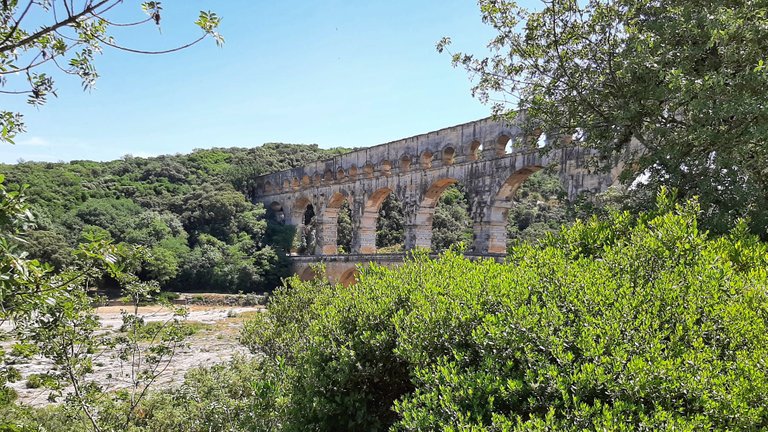
The Pont du Gard: Roman Water Mains from Antiquity
O.K., somebody has built something. Notwithstanding my lame attempt at building suspense and introducing some comic relief, we have arrived at the tallest of all Roman aqueduct bridges: the Pont du Gard near the town Vers-Pont-du-Gard, between Avignon and Nîmes. This is one of the most important and best preserved bridges of the ancient Roman world and one of the most important sights of southern France. The view from the air reveals the stunning architecture and impressive dimensions of this marvel of antique engineering:

Der Pont du Gard: Römische Wasserleitung aus der Antike
Okay, jemand hat etwas gebaut. Trotz meines lahmen Versuchs, Spannung aufzubauen und etwas Komik einzustreuen, sind wir an der höchsten aller römischen Aquäduktbrücken angekommen: der Pont du Gard in der Nähe der Stadt Vers-Pont-du-Gard, zwischen Avignon und Nîmes. Dies ist eine der bedeutendsten und am besten erhaltenen Brücken der römischen Antike und eine der wichtigsten Sehenswürdigkeiten in Südfrankreich. Der Blick aus der Luft offenbart die überwältigende Architektur und die beeindruckenden Dimensionen dieses Wunderwerks antiker Ingenieurskunst.
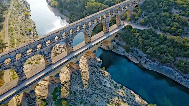
The Pont du Gard was part of a water pipeline about 50km (31 miles) long, which was used to transport water from the springs of the Fontaine d'Eure near Ucetia (Uzès) to the Roman city of Nemausus (Nîmes). The bridge is almost 50m (164') tall, 275m (902') long at the top level, and consists of a total of 52 arches that transfer the immense weight of the structure into the ground. On the upper level, the water was carried by a rectangular channel, 1.80m high and 1.20m wide (6' x 4'), with a gentle slope of 0.34 ‰.
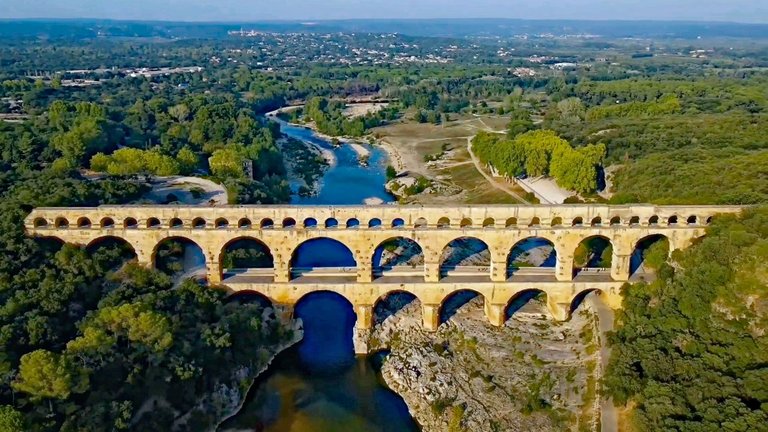
Der Pont du Gard war Teil einer etwa 50 km langen Wasserleitung, mit der Wasser von den Quellen der Fontaine d'Eure nahe Ucetia (Uzès) zur römischen Stadt Nemausus (Nîmes) transportiert wurde. Die Brücke ist fast 50m hoch, in der obersten Etage 275m lang und besteht aus insgesamt 52 Bögen, die das immense Gewicht der Konstruktion in den Boden ableiten. Auf der oberen Ebene verläuft die Wasserleitung als rechteckige Rinne, die 1,80m hoch und 1,20m breit ist und ein sanftes Gefälle von 0,34 ‰ aufweist.
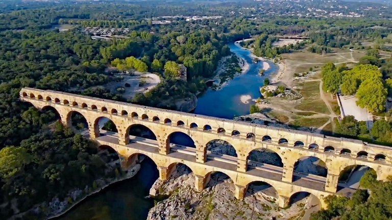
The bridge was built to cross the valley of the river Gardon, which in Roman times was called Vardo Fluvius. 20,000 cubic meters (5.3 million gallons) of water flowed daily over this magnificent aqueduct to Nîmes (Nemausus), which at the time had about 20,000 inhabitants. Accordingly, theoretically, about 1,000 liters (264 gallons) of water were available to each inhabitant every day.
Die Brücke wurde gebaut, um das Tal des Flusses Gardon, der in römischer Zeit Vardo Fluvius hieß, zu überwinden. 20.000 Kubikmeter Wasser flossen täglich über diesen prächtigen Aquädukt nach Nîmes (Nemausus), das zu der Zeit etwa 20.000 Einwohner hatte. Demnach standen theoretisch täglich jedem Einwohner rund 1.000 Liter Wasser zur Verfügung.
The lower level of the bridge, which today is only used as a footbridge for visitors, was actively traveled by cars and trucks as late as the 1950s, when the bridge was part of the connecting road between Avignon and Alès (today's D981). This portion of the bridge is not really from Roman times, but was "stuck on" in the 18th century to facilitate traffic across the river.
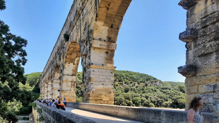
Die untere Ebene der Brücke, die heute nur noch als Fußgängerbrücke für Besucher genutzt wird, wurde noch in den 1950er Jahren aktiv von Autos und Lastwagen befahren, als die Brücke Teil der Verbindungsstraße zwischen Avignon und Alès war (die heutige D981). Dieser Teil der Brücke stammt nicht wirklich aus der Römerzeit, sondern wurde im 18. Jahrhundert "angeklebt", um den Verkehr über den Fluss zu erleichtern.
The Pont du Gard aqueduct was inscribed on the UNESCO World Heritage List in 1985.
Der Aquädukt Pont du Gard wurde 1985 in die UNESCO-Liste des Welterbes aufgenommen.
A Leisurely Evening in Arles
Just upstream of the city of Arles the river Rhône forks into two branches, thus forming the Camargue delta, France's largest wetlands. That makes Arles the perfect jumping-off point for a Camargue visit. We, however, weren't there for that. Like any artist worth his salt, we came for the special southern light, just like Pablo Picasso, Paul Gauguin, and Vincent van Gogh before us. ;-)
Ein gemütlicher Abend in Arles
Unmittelbar flussaufwärts der Stadt Arles gabelt sich die Rhône in zwei Arme und bildet so das Delta der Camargue, das größte Feuchtgebiet Frankreichs. Das macht Arles zum perfekten Ausgangspunkt für einen Besuch der Camargue. Wir waren jedoch nicht aus diesem Grund dort. Wie jeder Künstler, der etwas auf sich hält, kamen wir wegen des besonderen südlichen Lichts, genau wie schon Pablo Picasso, Paul Gauguin und Vincent van Gogh vor uns. ;-)
O.K., those were some big words now from a hobby painter :-) but I'm sure a few paintings of ours will be forthcoming on Hive when the travel season is over and the days get shorter and darker. In the meantime, I leave you with this masterpiece by Vincent van Gogh which depicts a café in Arles at night:
Okay, das waren jetzt große Worte von einem Hobbymaler :-) aber ich bin sicher, dass ein paar Bilder von uns auf Hive erscheinen werden, wenn die Reisesaison vorbei ist und die Tage wieder kürzer und dunkler werden. In der Zwischenzeit überlasse ich euch dieses Meisterwerk von Vincent van Gogh, das ein Café in Arles bei Nacht zeigt:
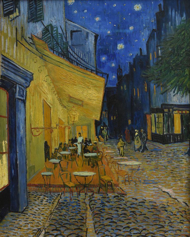
Vincent van Gogh: Caféterras bij nacht (public domain)
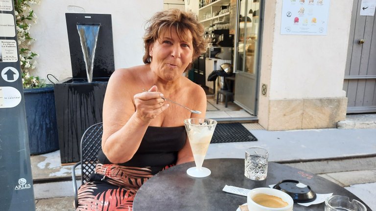
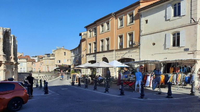
Long story short: we had stopped in Arles not to tour all manner of interesting sights, but simply to enjoy ourselves for a few hours. Culture is great and all that, but what's a vacation without a little fun, good food, and ice cream?
Lange Rede, kurzer Sinn: Wir waren nicht nach Arles gekommen, um alle möglichen Sehenswürdigkeiten zu besichtigen, sondern einfach, um es uns ein paar Stunden gutgehen zu lassen. Kultur ist ja schön und gut, aber was ist ein Urlaub ohne ein bisschen Spaß, gutes Essen und Eiscrème?
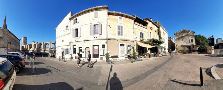
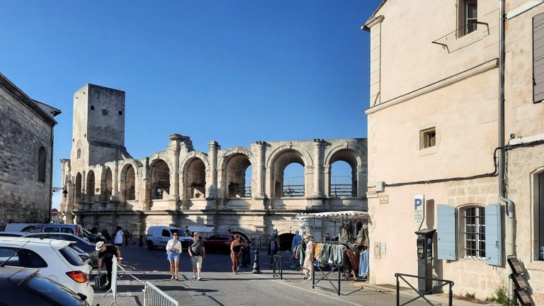

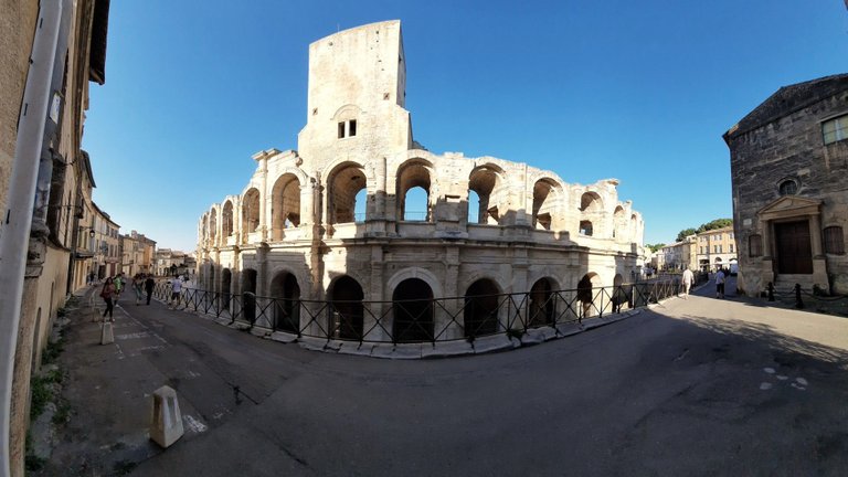
Arles (Arelate) was a city of considerable importance in the Roman province of Gallia Narbonensis. Consequently, a number of Roman monuments can be seen throughout the city. The Arènes d'Arles (Arles Amphitheatre), a two-tierd Roman amphitheatre from 90 AD, is chief among them. In Roman times, 20,000 spectators watched chariot races and bloody gladiator combat here. The building is listed as a UNESCO World Heritage Site.
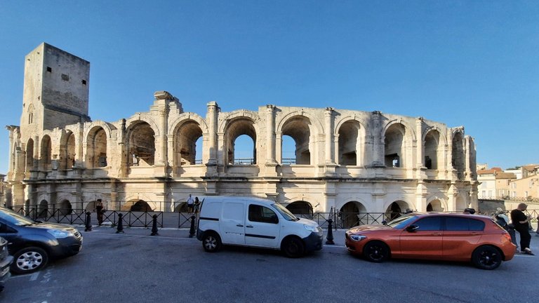
Arles (Arelate) war eine Stadt von großer Bedeutung in der römischen Provinz Gallia Narbonensis. Dementsprechend finden sich überall in der Stadt zahlreiche römische Bauwerke. Die Arènes d'Arles (Amphitheater von Arles), ein zweigeschossiges römisches Amphitheater aus dem Jahr 90 n. Chr. ist das wichtigste von ihnen. In der Römerzeit verfolgten hier 20.000 Zuschauer Wagenrennen und blutige Gladiatorenkämpfe. Das Gebäude gehört zum UNESCO-Weltkulturerbe.
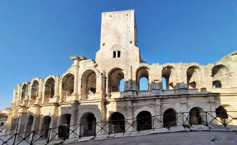
Nowadays, the arena is used for concerts, plays, and bullfighting. Unlike other places in France, where the bull is not harmed, bullfighting in Arles is of the bloody Spanish variety. Arles has an "unbroken local tradition" of this, which is what French law requires to let this animal abuse go on. France's dirty little secret...
BTW, the tower extension on the building is not of Roman origin, but a medieval add-on.
Heutzutage wird die Arena für Konzerte, Theateraufführungen und Stierkämpfe genutzt. Im Gegensatz zu anderen Orten in Frankreich, wo der Stier nicht verletzt wird, ist der Stierkampf in Arles von der blutigen spanischen Variante. In Arles gibt es eine "ungebrochene lokale Tradition", die nach französischem Recht die Voraussetzung für diese Tierquälerei ist. Frankreichs schmutziges kleines Geheimnis...
Der Turmaufsatz auf dem Gebäude ist übrigens nicht römischen Ursprungs, sondern ein mittelalterliches Anhängsel.
The Mediterranean: Is It Still Here?
Ancient Arles was much closer to the sea than it is now and served as a major seaport. The Rhône, however, has carried centuries of silt that has filled in the former harbor. So, although not strictly part of our travel plans, it made sense for us to make a quick run for the sea the next day, being so close and all... Just to make sure it was still here!
Das Mittelmeer: Ob es wohl noch da ist?
Das antike Arles lag viel näher am Meer als heute und war ein wichtiger Seehafen. Die Rhône hat jedoch jahrhundertelang Schlick mitgeführt, der den ehemaligen Hafen aufgefüllt hat. Obwohl es eigentlich nicht zu unseren Reiseplänen gehörte, war es sinnvoll, am nächsten Tag einen kurzen Abstecher zum Meer zu machen, da es ja echt nah war und so... Nur um sicherzugehen, dass es noch da war!
Absolutely, positively, the more scenic route from Arles to the sea is the D570 down to Saintes-Maries-de-la-Mer, as it goes right through the Camargue, and one can observe wild horses and flamingos from the side of the road. Saintes-Maries-de-la-Mer is also an important place of pilgrimage for the Gitans (Roma of mostly spanish origin) and you can experience interesting bits of European gipsy culture down there, besides a gorgeous beach.
Die landschaftlich reizvollste Strecke von Arles zum Meer ist die D570 nach Saintes-Maries-de-la-Mer, denn sie führt mitten durch die Camargue, und man kann vom Straßenrand aus Wildpferde und Flamingos beobachten. Saintes-Maries-de-la-Mer ist auch ein wichtiger Wallfahrtsort für die Gitans (Roma meist spanischer Abstammung) und man kann dort neben einem wunderschönen Strand auch interessante Einblicke in die europäische Zigeunerkultur bekommen.
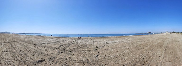
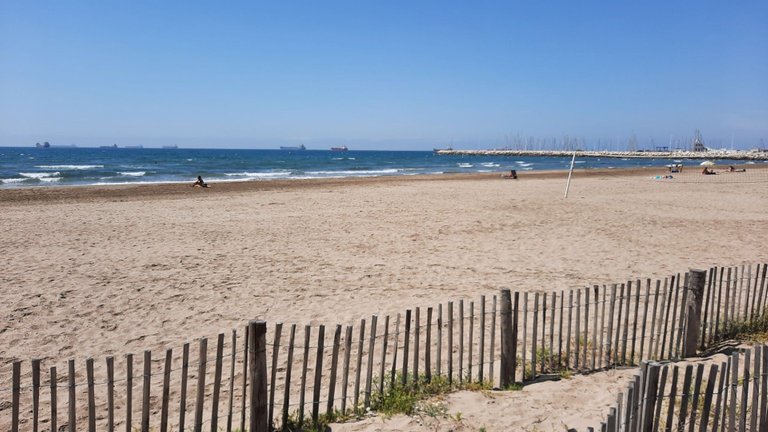
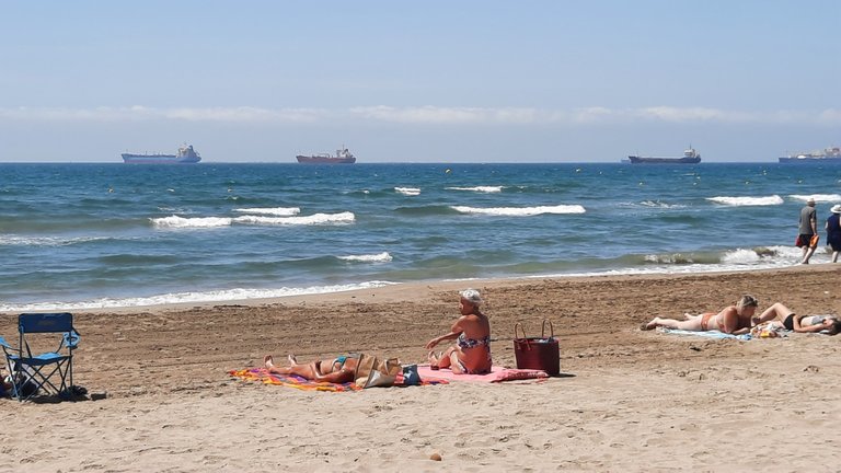
Been there, done that, so we headed down to Port-Saint-Louis and Fos-sur-Mer instead, as this was the lesser detour for us on the way to our next stop, and ultimately home. There is a decent enough beach in Fos-sur-Mer, however, the area is heavily industrialized, with the seaport of Marseille-Fos dominating the area. The outright massive facilities include container handling, oil and gas terminals, an ExxonMobil oil refinery and an ArcelorMittal steel plant! ;-)
In short: a spot for a perfect beach vacation. Hey, pollution is overrated, right? They actually do have a tourist office in town. "Hope springs eternal" must be the mayor's life motto... That said, it is interesting to watch the many ships at anchor lined up on the horizon, waiting to get in port.
Alles schonmal gemacht, also fuhren wir stattdessen nach Port-Saint-Louis und Fos-sur-Mer, da dies für uns der kleinere Umweg auf dem Weg zu unserer nächsten Station und letztendlich nach Hause war. In Fos-sur-Mer gibt es einen halbwegs anständigen Strand, aber die Gegend ist extremst industrialisiert, und der Seehafen von Marseille-Fos dominiert alles. Zu den riesigen Anlagen gehören Containerumschlag, Öl- und Gasterminals, eine ExxonMobil-Ölraffinerie und ein ArcelorMittal-Stahlwerk! ;-)
Kurzum: ein Ort für einen perfekten Strandurlaub. Hey, Umweltverschmutzung ist doch sowieso überbewertet, oder? Es gibt sogar ein Fremdenverkehrsbüro in der Stadt. "Die Hoffnung stirbt zuletzt" muss das Lebensmotto des Bürgermeisters sein... Abgesehen davon ist es tatsächlich interessant, die vielen Schiffe auf Reede zu beobachten, die am Horizont aufgereiht darauf warten, in den Hafen zu kommen.
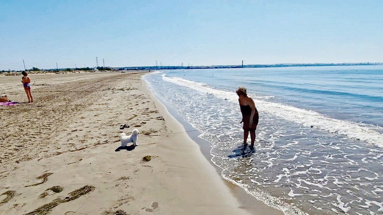
Prime beaches like the one in Fos-sur-Mer do have one big advantage: absolutely nobody cares, when you bring your dog! Naturally, we were curious how Gizmo would react, seing the sea for the first time in his puppy life. There was quite a breeze that day, and the waves were kinda crashing on the beach. Oh what a gastly, thundering noise for a little puppy! So he wasn't going anywhere near the source of that terrible noise, rendering Caroline's repeated cooing and coaxing an exercise in futility. :-)
Erstklassige Strände wie der in Fos-sur-Mer haben allerdings einen großen Vorteil: Kein Mensch regt sich auf, wenn man seinen Hund mitbringt! Natürlich waren wir gespannt, wie Gizmo reagieren würde, wenn er zum ersten Mal in seinem Welpenleben das Meer zu sehen bekam. An diesem Tag wehte jedoch eine ziemliches Lüftchen, und die Wellen schlugen einigermaßen kräftig an den Strand. Oh, was für ein schreckliches, donnerndes Geräusch für so einen kleinen Hund! Also ging er nichtmal in die Nähe der Quelle dieses schrecklichen Lärms, nicht für Geld und gute Worte, egal was Caroline anstellte, um ihn zu locken! :-)
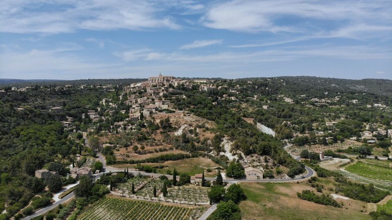
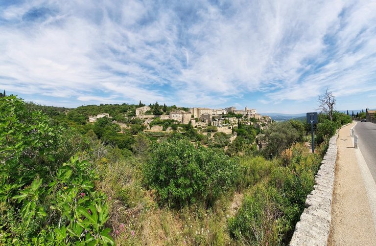
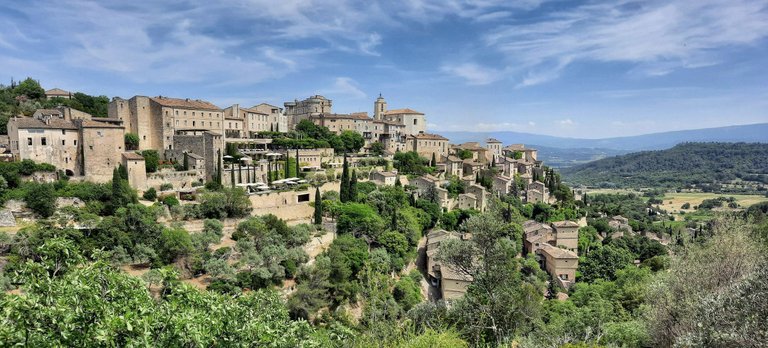
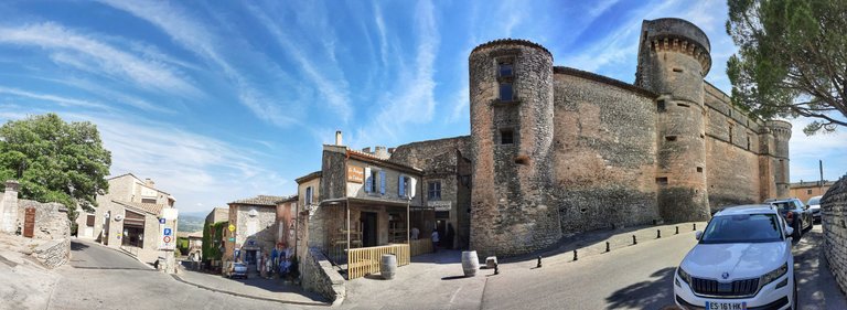
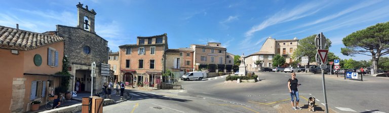
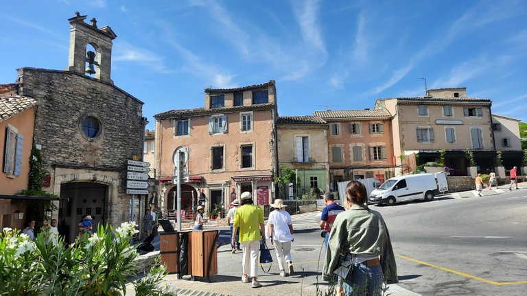
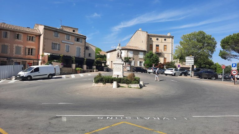
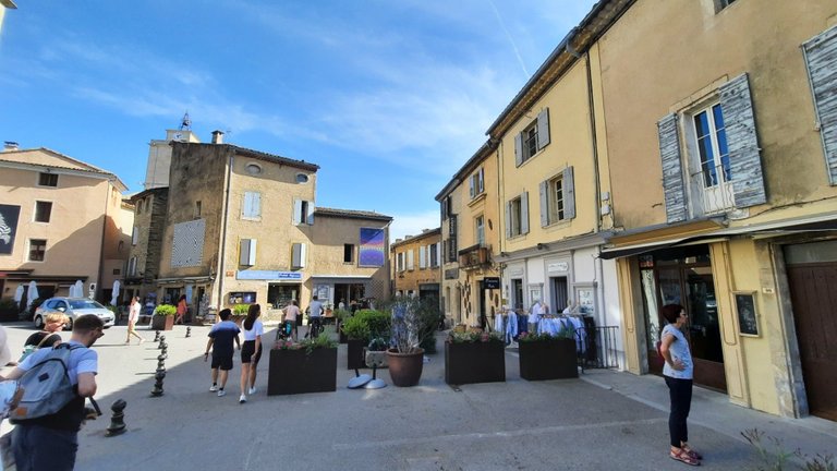
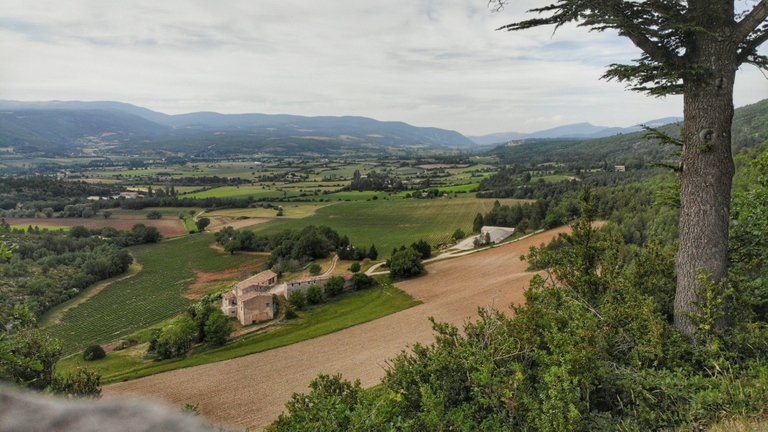
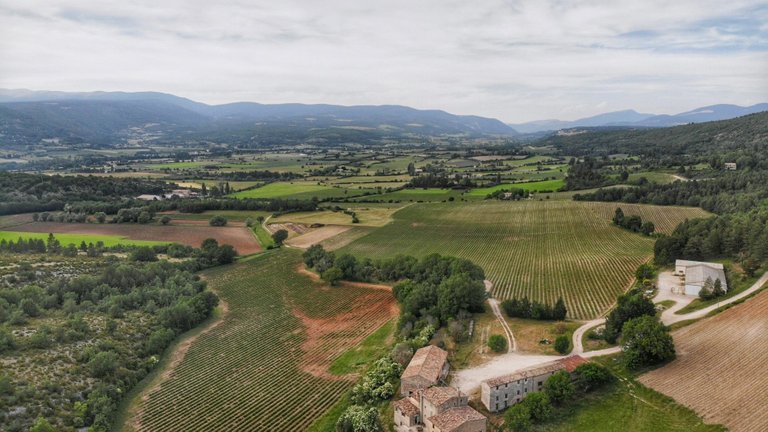
Gordes: A Medieval Village in the Luberon
The Luberon is a massif in central Provence in Southern France, part of the French Prealps. The english-speaking world knows the Luberon from the books by British author Peter Mayle and the movie "A Good Year" (2006) directed by Ridley Scott, starring Russell Crowe, which was filmed in the region. The Luberon is a regional nature preserve.
The village Gordes (Département Vaucluse) is classified as one of the prettiest villages of France ("Plus beaux villages de France"). It lies on the southern flank of the Monts de Vaucluse, grafted onto a rocky outcrop over the valley of the river Coulon.
Gordes: Ein mittelalterliches Dorf im Luberon
Der Luberon ist ein Gebirgsmassiv in der zentralen Provence in Südfrankreich, das zu den französischen Voralpen gehört. Besonders bekannt wurde der Luberon durch die Bücher des britischen Autors Peter Mayle und den Film "Ein gutes Jahr" (2006) von Ridley Scott mit Russell Crowe in der Hauptrolle, der in der Region gedreht wurde. Der Luberon ist ein regionales Naturschutzgebiet.
Das Dorf Gordes (Département Vaucluse) ist klassifiziert als eines der schönsten Dörfer Frankreichs ("Plus beaux villages de France"). Es liegt an der Südflanke der Monts de Vaucluse, auf einem Felsvorsprung über dem Tal des Flusses Coulon.
Being painters, for Caroline and me the South of France holds a number of interesting places in terms of art. The French painter Paul Vayson was born in Gordes, and Gordes was once home to Marc Chagall. Chagall, fleeing Paris on account of WWII, painted a number of his works in Gordes. So, if Gordes was good enough for Monsieur Chagall, it's good enough for us, right? As an example, here is a gouache from Chagall's time in Gordes:
Für Caroline und mich, als Maler, bietet Südfrankreich eine Reihe interessanter Orte mit Kunstbezug. Der französische Maler Paul Vayson war gebürtig aus Gordes, und Gordes war einst die Heimat von Marc Chagall, der wegen des Zweiten Weltkriegs aus Paris floh und in Gordes einige seiner Werke malte. Wenn Gordes also gut genug für Monsieur Chagall war, ist es auch gut genug für uns, oder? Hier ist zum Beispiel eine Gouache aus Chagalls Zeit in Gordes:
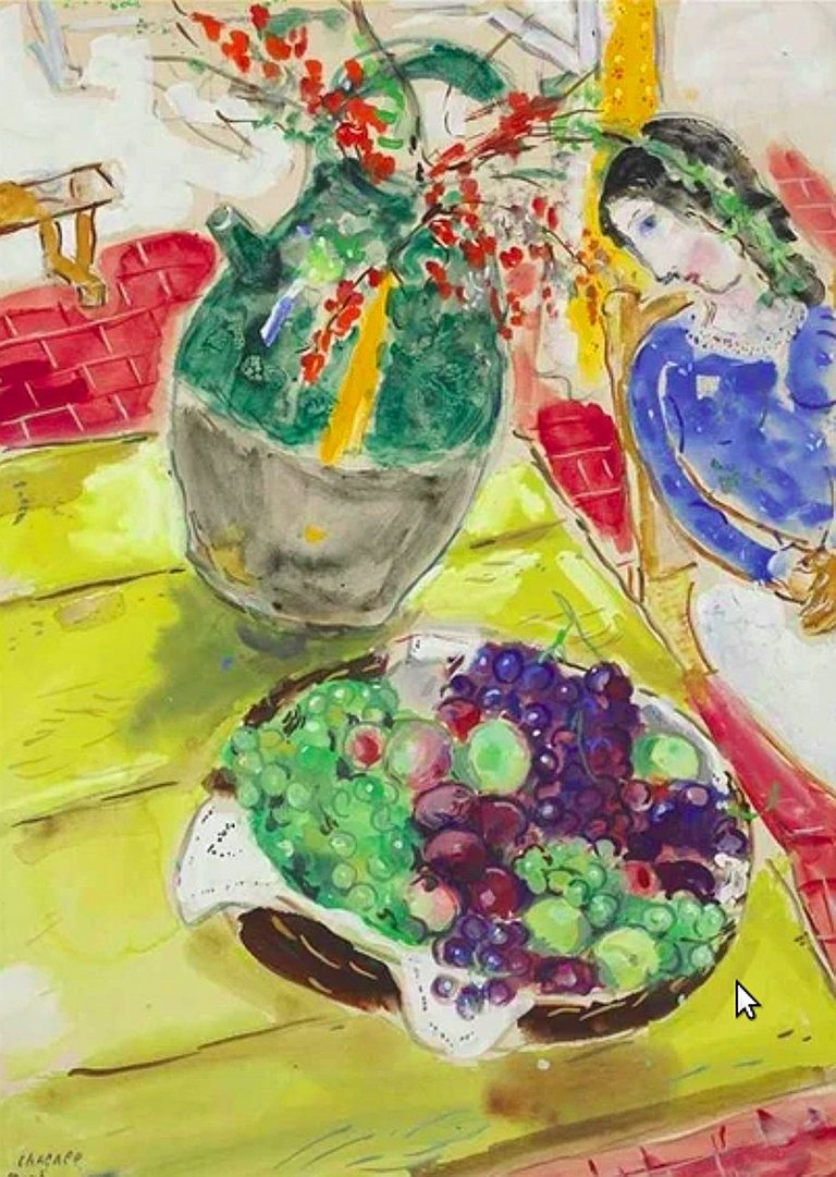
Marc Chagall: Fruits et fleurs ou Nature morte à Gordes (public domain)
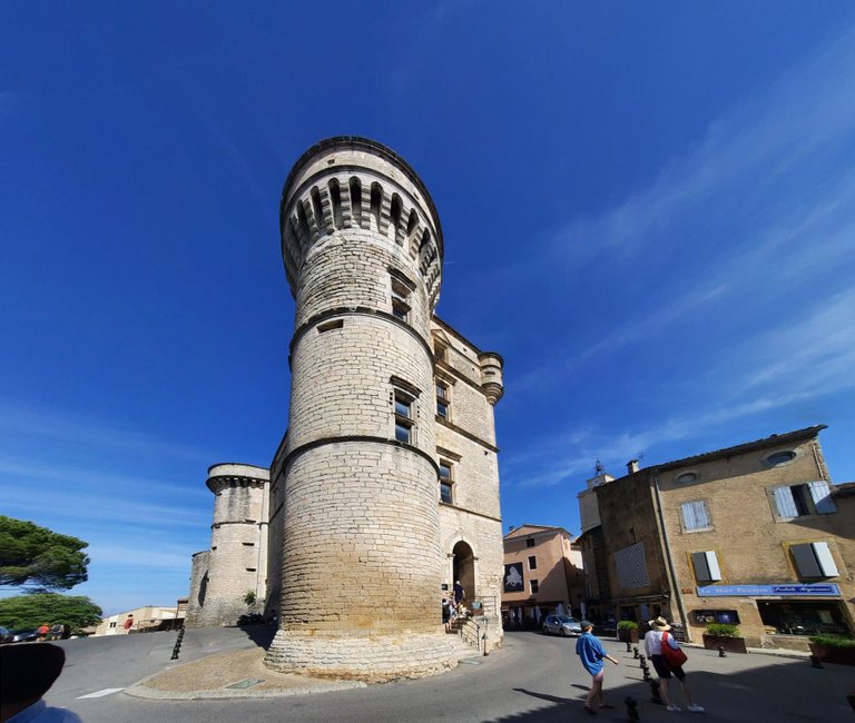
The Château de Gordes, a massively fortified castle from the 11th century dominates the village. There is an art museum (no major works, though) and the local tourist office in the castle. Supposedly, there are a number of historically significant fireplaces from the renaissance, the oldest dated 1541. We skipped that, as it was too nice a day to be inside, and we would have had to take turns again because of Gizmo.
Das Château de Gordes, eine massive Burg aus dem 11. Jahrhundert, beherrscht das Weichbild des Dorfs. In der Burg befinden sich ein Kunstmuseum (allerdings keine großen Werke) und das örtliche Fremdenverkehrsamt. Angeblich gibt es dort eine Reihe historisch bedeutsamer Kamine aus der Renaissance, der älteste datiert auf 1541. Das haben wir ausgelassen, denn es war ein zu schöner Tag, um drinnen zu sein, und wir hätten uns wegen Gizmo wieder abwechseln müssen.
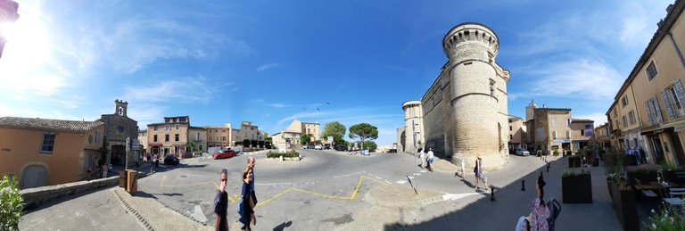
For tourists there is quite a number of interesting places and sights in and around Gordes, but for us it was once again just a neat place to walk around and enjoy a gorgeous afternoon. I already explained this: there is a limit on sightseing, before a relaxing vacation turns into a forced march of hitting every possible highlight. We rather come back another time; luckily, it ain't that far for us.
Für Touristen gibt es eine ganze Reihe interessanter Orte und Sehenswürdigkeiten in und um Gordes, aber für uns war es wieder einmal nur ein netter Ort, an dem wir spazieren gehen und einen herrlichen Nachmittag genießen konnten. Ich habe es ja schon erklärt: es gibt eine Grenze für Sightseeing, bevor ein erholsamer Urlaub zu einem Gewaltmarsch wird, bei dem man alle möglichen Highlights abklappert. Wir kommen lieber ein anderes Mal wieder; zum Glück ist es für uns ja nicht so weit.
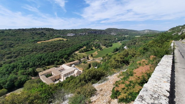
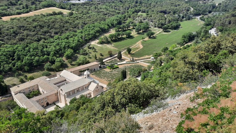
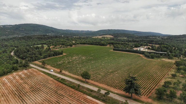
Notre-Dame de Sénanque and the Lavender that Wasn't Purple
Just a few klicks from Gordes there is a valley which is home to a Cistercian abbey since 1148. Manual labor, especially agricultural work in the fields, is supposed to be a special characteristic of Cistercian life. In the case of Sénanque, the abbey is surrounded by lavender fields; lavender being one of the cash crops of choice in the Provence.
We had started our trip in hopes of catching lavender blooming season, which typically goes from June to August. June is early, but I have personally seen blossoming lavender fields as early as mid-May in the past. It all depends on how warm the preceding winter has been. Anyway, the appointment book only left us the first week of June, so we gave it a shot. With all that global warming everybody keeps harping about, how could it fail?
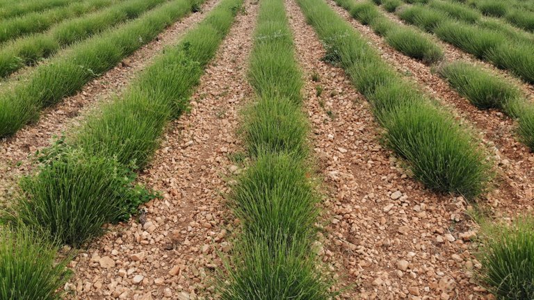
In blooming season, this valley would be a sea of purple (see photo further down). When we were there, it was a sea of "not purple" - the green of unripe plants. Mystery solved. :-(
Notre-Dame de Sénanque und der Lavendel, der nicht lila war
Nur wenige Kilometer von Gordes entfernt befindet sich ein Tal, das seit 1148 eine Zisterzienserabtei beherbergt. Eigener Hände Arbeit, insbesondere die landwirtschaftliche Arbeit auf den Feldern, soll ein besonderes Merkmal des zisterziensischen Lebens sein. Im Fall von Sénanque ist die Abtei von Lavendelfeldern umgeben; der Lavendel gehört ja zu den beliebtesten Nutzpflanzen der Provence.
Wir hatten unsere Reise in der Hoffnung begonnen, die Lavendelblüte zu erwischen, die normalerweise von Juni bis August dauert. Juni ist früh, aber ich persönlich habe blühende Lavendelfelder auch schon Mitte Mai gesehen. Es hängt alles davon ab, wie warm der vorangegangene Winter war. Wie auch immer, ein voller Terminkalender ließ uns nur die erste Juniwoche übrig, also haben wir einen Versuch gewagt. Mit der globalen Erwärmung, von der alle immer reden, konnte es doch nicht scheitern?
In der Blütezeit wäre das Tal ein Meer aus Lila (siehe Foto weiter unten). Als wir dort waren, war es ein Meer aus "nicht lila" - dem Grün der unreifen Pflanzen. Und damit ist das Rätsel auch gelöst. :-(
As I mentioned before, I had experienced blossoming lavender fields in years past, so that's off my bucket list, but the utter disappointment on Caroline's face was palpable!
Near Saint-Remèze, in the Ardèche (where we camped, see above) there is a place called Maison de la Lavande (House of Lavender). It's really neat, because they take tourists through their lavender fields in one of those choo-choo trains. I had driven by there without telling Caroline while we were looking for a camp spot, to check on the state of the fields. They were green then :-( but I was hoping that a few more days, a few kilometers further south, a little warmer climate might make a difference. Locals whom I talked to assured me it would only be a matter of days...
Wie ich schon sagte, hatte ich in der Vergangenheit schon blühende Lavendelfelder gesehen, das ist damit also von meiner Bucket List gestrichen, aber die schiere Enttäuschung in Carolines Gesicht war kein schöner Anblick!
In der Nähe von Saint-Remèze in der Ardèche (wo wir gecampt haben, siehe oben) gibt es einen Ort namens Maison de la Lavande (Haus des Lavendels). Das ist ganz nett, denn dort werden Touristen in einem dieser Bimmelbähnchen durch die Lavendelfelder gekarrt. Ich war dort vorbeigefahren, um nach dem Zustand der Felder zu sehen - ohne es Caroline gegenüber zu erwähnen, als wir auf der Suche nach einem Schlafplatz waren. Da waren sie noch grün :-( aber ich hatte gehofft, dass ein paar Tage mehr, ein paar Kilometer weiter südlich und ein etwas wärmeres Klima einen Unterschied machen würden. Die Einheimischen, mit denen ich sprach, versicherten mir, dass es nur noch eine Frage von Tagen sei...
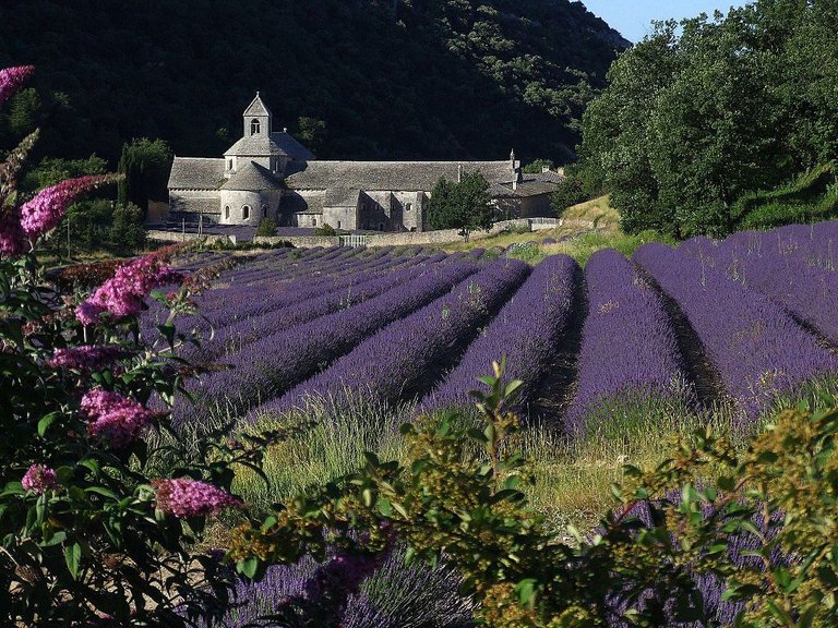
Blossoming Lavender at Sénanque Abbey. Photo by Hubert Tabutiaux via Wikimedia Commons.
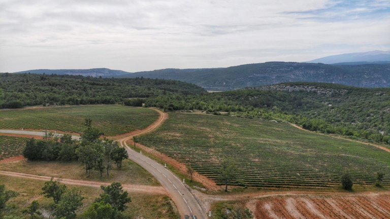
Let's Try Sault!
I just hate disappointing my darling wife! In my despair, I headed for the tiny village of Sault (Département Vaucluse) which is pretty much the lavender capital of France. Sault is situated within the Mont Ventoux nature preserve, so driving around there is a pretty scenic affair. It also happens to be kinda on the way home, so not that big a detour. You want to see lavender? Sault is the place!
Versuchen wir's mal in Sault!
Ich hasse es einfach, meine geliebte Frau zu enttäuschen! In meiner Verzweiflung steuerte ich das winzige Dorf Sault (Département Vaucluse) an, das so etwas wie die Lavendelhauptstadt Frankreichs ist. Sault liegt im Naturschutzgebiet des Mont Ventoux, so dass die Fahrt dorthin eine landschaftlich reizvolle Angelegenheit ist. Außerdem liegt es auf dem Heimweg, so dass der Umweg nicht so schrecklich groß ist. Du willst Lavendel sehen? Sault ist der richtige Ort!
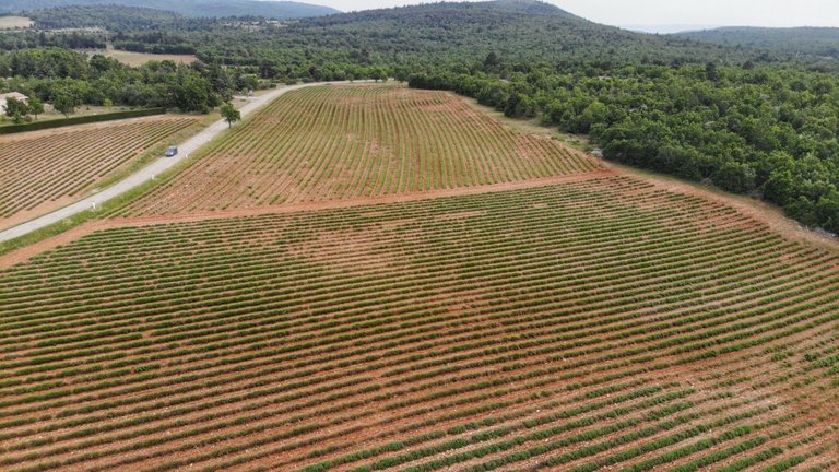
What more can I say? Just look at the drone shots here: not even a hint of purple to be had, at any price! But I'll make you a promise:
I have three free days starting the 29th of June. If the upvotes on this post touch $500.00 I will personally drive down there again and fly my drone over more purple lavender than you'll ever want to see. How about it, whales?
Was soll ich noch sagen? Schaut euch die Drohnenaufnahmen hier an: nicht einmal ein Hauch von Lila ist zu sehen, für kein Geld der Welt! Aber ich verspreche euch etwas:
Ich habe ab dem 29. Juni drei freie Tage. Wenn die Upvotes für diesen Beitrag 500,00 Dollar erreichen, werde ich persönlich nochmal da runter fahren und mit meiner Drohne über mehr lila Lavendel fliegen, als ihr jemals sehen wollt. Wie schaut's, Wale?
Thanks for watching, thanks for reading, and please don't forget to upvote and reblog if you liked my post. Until next time!
P.S.: There is a Part 1 of this story, in case you missed it. Cheers!
Danke fürs Anschauen, danke fürs Lesen, und vergesst bitte nicht das Upvoten und Rebloggen, wenn euch mein Beitrag gefallen hat. Bis zum nächsten Mal!
PS: Zu dieser Geschichte gibt es einen Teil 1, falls Du den verpasst hast. Tschüs!
Click here to watch an entertaining 20-minute video of the whole trip.
Klicke hier für ein unterhaltsames 20-minütiges Video der ganzen Reise.
Für den Monatspreis der Liebe im Mai 2022 wurden die auf der Steemengine 500 µLOVE gut geschrieben. Diese kannst Du dort auch staken und für mindestens 1 Jahr festlegen. Je nach Höhe Deines Stakes erhälst Du dann LOVE-Anteile auf der HIVE Engine.
Beste Grüße und ein sonniges Wochenende.
SEND with LOVE!
!BEER
TRANSACTION
9.7.2022, 11:36:51
Transaction ID:
1231921736f8c03bdd5749818f679479d4f8e690
Sidechain Block: 10163539
From: @janasilver
To: @wulff-media
Amount: - 0.00000500 LOVE
Memo: Nachträgliche Liebesgrüße ;o) zum Monatspreis der Liebe im Mai 2022. Beste Grüße. SEND with LOVE!
Danke und auch dir einen schönen Sonntag.
!BEER !invest_vote !PIZZA !LUV !LOL !wine !hivebits
Dankeschön 😃
!BEER !invest_vote !PIZZA !LUV !LOL !wine !hivebits
Dankeschön 😃
lolztoken.com
But I can see mine on my counter.
Credit: reddit
@wulff-media, I sent you an $LOLZ on behalf of @indextrader24
Use the !LOL or !LOLZ command to share a joke and an $LOLZ
(2/2)
The rewards earned on this comment will go directly to the people(@acidyo) sharing the post on Twitter as long as they are registered with @poshtoken. Sign up at https://hiveposh.com.
Thanks for sharing that. I'm done w/ Twitter (don't like to be censored) but the platform no doubt has serious reach.
Ohh wie schön!!! Als Kind war ich in vielen Sommerurlauben in Südfrankreich, unter anderem auch in Arles, auch die Pont du Garde, die Lavendelfelder und der Duft dazu ist mir sehr vertraut und Erinnerungen kommen grad wieder hoch. So schön! Danke für den tollen Blog und die wunderschönen Bilder!
Danke fürs Anschauen; schön, dass es dir gefallen hat. :-)
Ja, wunderschön!
That looks like an incredible trip. I'm so glad you were able to go after all of the previous covid crap and then the health issues with your dog a while back and all that.
Gordes is amazing and it's great that the lavender was in bloom for you at the Abbey. We went too early for that last year. Seeing Arles in your posts was nice because we were supposed to go this year but it didn't work out for us. I can experience it vicariously through you 👍
Incredible drone shots of the bridge and gorge.
Great post!
Thanks Dane. You didn't read it right :-)
No, it wasn't! The picture is from Wikimedia Commons, source given, to illustrate what it's supposed to look like.
Yeah, us, too. We only had the first week of June open, so we went. I had high hopes, having had a warm winter and all, but it didn't pan out. A matter of days too soon I understand.
The original idea was to catch the bloom at Maison de la Lavande in the Ardèche. Their fields are big enough to be impressive, and it would have saved a bunch of driving to the other side of the Rhône. Two birds with one stone.
Yeah, me too. Been tied down for a loooong time. It really sucks, when you're done building a camper and have it sit uselessly by the house. Finally got that diesel heater in, too - which is practically a guarantee that this will become the hottest summer on record well into December, from the North Cape to Gibraltar. I won't need it for months to come. That's how the gods of my fortune tend to fuck with me. :-)
We didn't do much in Arles, just parked the van by the flea market ('cause it looks like a vendor's van and fits right in) and walked over to the Arènes to eat, drink, and be merry. Sorry about that. No flying there - very verboten.
I can't leave my mom alone in the house for more than 4, 5 days, otherwise her care costs more than a year's worth of vacations. So I steal the time I can.
Have a great Sunday!
Congratulations, your post has been added to Pinmapple! 🎉🥳🍍
Did you know you have your own profile map?
And every post has their own map too!
Want to have your post on the map too?
Hiya, @LivingUKTaiwan here, just swinging by to let you know that this post made it into our Top 3 in Daily Travel Digest #1591.
Your post has been manually curated by the @pinmapple team. If you like what we're doing, please drop by to check out all the rest of today's great posts and consider supporting other authors like yourself and us so we can keep the project going!
Become part of our travel community:
Thank you kindly :-)
This is a wonderful post by you, informative and full of beauty. You captured the real beauty of nature, these places attract travelers, and after reading your post no one can stay without seeing this beauty.
Thank you for sharing all information.
Thank you for those kind words. :-)
To help the community of Hivians to discover the beauties of France, The French-speaking community, offers you **50 points-fr
Récompense d'engagement des Francophones
Merçi bien mon ami, aussi pour le reblog 😃
Wow, your post is like a bomb! Its huge , full of history and culture, beauty and nature and of course i feel the vibe of your trip! For the most of the place you visited i haven't heard before! Its like you trigger my mind! I wish i could visit them one day! Until then i start googling for them for more information and photos! Thanks for all the time you spent, for this amazing work!
Thank you, I'm so glad you liked it. Yes, when I travel I try to have a mix of well-known places, and places off the beaten path. I just wish I had more time and money :-)
Hello @wulff-media, wow, what a beautiful post. Congratulations, for allowing to travel with you through the mind, spectacular photos, even here I got the smell of lavender uhm, what a spectacular aroma. Thank you very much for sharing such a spectacular trip. May the universe continue to bless you.
Thank you very much for those kind words. 😃
Thank you for sharing this amazing post on HIVE!
Your content got selected by our fellow curator @priyanarc & you just received a little thank you via an upvote from our non-profit curation initiative!
You will be featured in one of our recurring curation compilations and on our pinterest boards! Both are aiming to offer you a stage to widen your audience within and outside of the DIY scene of hive.
Join the official DIYHub community on HIVE and show us more of your amazing work and feel free to connect with us and other DIYers via our discord server: https://discord.gg/mY5uCfQ !
If you want to support our goal to motivate other DIY/art/music/homesteading/... creators just delegate to us and earn 100% of your curation rewards!
Stay creative & hive on!
Thank you 😃
Die übliche Sonntagslektüre kann ich getrost in die Ecke schmeißen. Der Herr Wulff hat mich gerade eingetextet bis über beide Ohren. Und dann ist auch noch großes Kino angesagt ...
Für das Mittagessen sieht es auch nicht sonderlich rosig aus! :-)
Also Mittagessen ausfallen lassen geht gar nicht! De wääscht jo, wann mir erschdemol was gess hann, geschafft hammir schnell!
Hättschd du disch mool am Riieme geriss un net gleisch e ganzes Teschdament in die Welt geschtanzt, dann gääbs aach bei uns um zweelf was se esse. Awwer so siien isch schwarz. zuumool isch was aus Mangold, Zucchini unn frische Schteenpilz zaubere muss - unn kää Schdick Flääsch in Sischt!
Tja, wann de jetzat bei de Metzjer tabbe unn e Schwengga hole kennsch... Selwat Schuld, was wonsch du aach auswärts!
It's as if you wrote a whole travel guide to this part of the world.😁
Thanks. Yeah, that's the idea: if anybody else is going down there, give them some tips on what to see where, and what to do or not to do. A mix of common sights, and ones that aren't on everybody's radar.
It's very helpful. Most people do their research first before visiting a certain place and this post is definitely gonna help. Thanks for sharing.🚬😎
Woww! This is so beautiful!.😍
Thank you 😃
This is indeed majestic, I love ti.
Thank you. I'm glad you enjoyed it. :-)
You're welcome (^_^)
hello dear friend @wulff-media good day
Excellent post, what a beautiful experience to know this charming place, without a doubt a destination that I would love to visit
I appreciate that you let us know all the information and the beautiful collection of images
have a beautiful day
Thank you, I'm glad you like it. Yes, there is enough information to arouse curiosity and point everyone's trip research in the right direction. The rest is then up to Google Maps and miscellaneous websites.
@janasilver denkt du hast ein Vote durch @investinthefutur verdient!
@janasilver thinks you have earned a vote of @investinthefutur !
View or trade
BEER.Hey @wulff-media, here is a little bit of
BEERfrom @janasilver for you. Enjoy it!Learn how to earn FREE BEER each day by staking your
BEER.@indextrader24 denkt du hast ein Vote durch @investinthefutur verdient!
@indextrader24 thinks you have earned a vote of @investinthefutur !
The video took about 40-50 hours to edit, including sorting and archiving of the media files and cleaning up the photos. Also includes a family version with lots of scenes deleted on Hive. Both parts of text post took about thirty hours. At a reasonable 65,00 EUR an hour, I would have to bill out 6,500.00 EUR + V.A.T.. Puts the rewards in perspective, doesn't it? But what the hell, it's a hobby. :-)