[ESP] Potosí, pueblo venezolano sumergido en las aguas por más de 30 años
[ENG] Potosí, Venezuelan people submerged in the waters for more than 30 years
Hola comunidad. Les saludo desde Venezuela. Hoy les traigo una historia muy interesante, se trata del Complejo Hidroeléctrico Leonardo Ruíz Pineda, mejor conocido como Uribante Caparo por el afluente del río Uribante que nace en las cordilleras del Estado Táchira y desemboca en el río Apure, formando parte de la cuenca del gran río Orinoco. Por otra parte el río Caparo, otro afluente del río Apure, el cual también forma parte de la cuenca del río Orinoco. El 30 de septiembre de 1987, se pone en marcha la primera etapa del Complejo Hidroeléctrico de la región andina venezolana, una de las obra de ingeniería más compleja del país. El presidente de Venezuela para la época, el Doctor Jaime Lusinchi, junto a más de diez mil personas fueron los protagonistas del magno evento.
Hello community. I greet you from Venezuela. Today I bring you a very interesting story, it is the Leonardo Ruíz Pineda Hydroelectric Complex, better known as Uribante Caparo by the tributary of the Uribante River born in the mountain ranges of Táchira State and flows into the Apure River, forming part of the basin of the great Orinoco River. On the other hand the Caparo River, another tributary of the Apure River, which is also part of the Orinoco River basin. On September 30, 1987, the first stage of the Hydroelectric Complex of the Venezuelan Andean region, one of the most complex engineering work in the country, was launched. Venezuela's president for the time, Dr. Jaime Lusinchi, along with more than ten thousand people were the protagonists of the magnificent event.
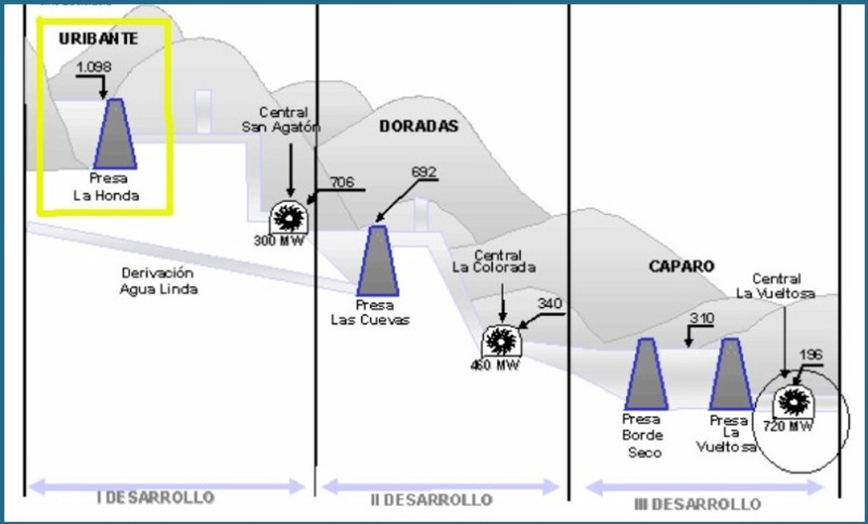
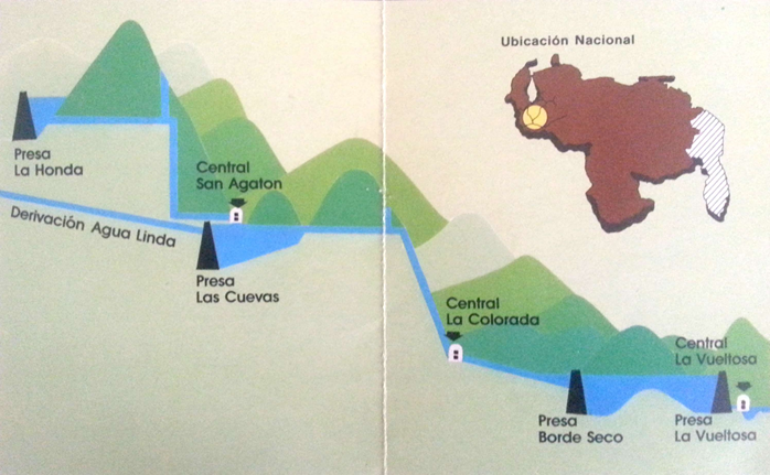
El complejo hidroeléctrico Leonardo Ruiz Pineda, trabaja con un sistema construido por las presas La Honda, Las Cuevas, Borde Seco y La Vueltosa, la obra fue ejecutada entre los años 1980 y 1986, dando origen a tres embalses. Las Presas de sección homogénea se diseñaron con una altura máxima de 140 m y una longitud de cresta de 730 m aproximadamente, su construcción fue principalmen con material arenoso y arcilloso. El sistema permite transportar el agua mediante una aducción o túnel trasvase revestido de hormigón hacia las tres centrales hidroeléctricas San Agatón (300 MW), La Colorada (460 MW) y La Vueltosa (720 MW). Fuente citada
The Leonardo Ruiz Pineda hydroelectric complex, working with a system built by the La Honda, Las Cuevas, Borde Seco and La Vueltosa dams, the work was executed between 1980 and 1986, giving rise to three reservoirs. The homogeneous section dams were designed with a maximum height of 140 m and a crest length of approximately 730 m, their construction was mainmen with sandy and clay material. The system allows water to be transported by a concrete-coated transvese aduction or tunnel to the three San Agatón hydroelectric plants (300 MW), La Colorada (460 MW) and La Vueltosa (720 MW). Source quoted
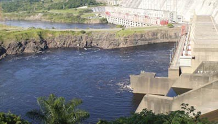
Estructura de máquina de la Represa la Honda, perteneciente al complejo hidroeléctrico Uribante Caparo "Dr. Leonardo Ruiz Pineda". Obra de ingeniería hidráulica para generar energía eléctrica al occidente de Venezuela. Fuente
Machine structure of the Represa la Honda, belonging to the Uribante Caparo hydroelectric complex "Dr. Leonardo Ruiz Pineda". Hydraulic engineering work to generate electricity to western Venezuela. Source
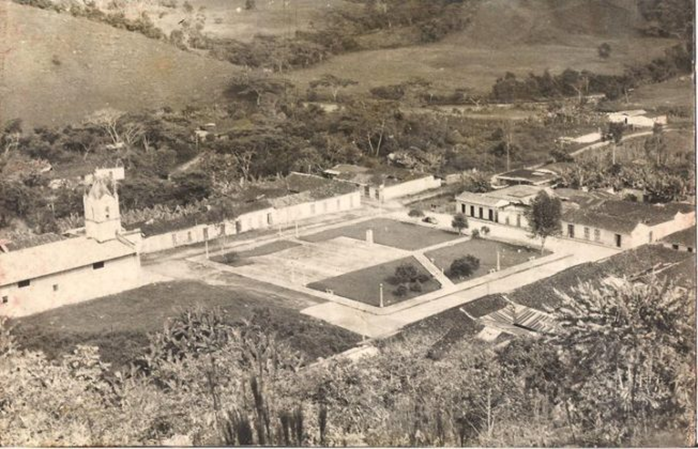
La historia que les relataré ocurrió en un antiguo pueblo de los andes venezolanos llamado Potosí el cual, por su ubicación, estaba destinado a sufrir una terrible inundación total y definitiva. Los expertos de la época, conociendo esta amenaza y el riesgo inminente en el que estaban expuestos sus pobladores, decidieron proponer al ejecutivo nacional un proyecto de envergadura para el cual era necesario desalojar completamente a los habitantes de Potosí, situación que se tornó problemática porque los lugareños se negaban a abandonar sus viviendas y su pueblo. Entre los años 1961 y 1962 se aprueba el proyecto denominado: Desarrollo Hidroeléctrico Uribante Caparo, Las autoridades insistieron hasta que en 1984 todos los habitantes del pueblo fueron desalojados y todos los terrenos expropiados por utilidad pública.
The story I will tell you occurred in an ancient people of the Venezuelan Andes called Potosí which, because of its location, was destined to suffer a terrible total and definitive flood. The experts of the time, knowing this threat and the imminent risk in which its inhabitants were exposed, decided to propose to the national executive a major project for which it was necessary to completely evict the inhabitants of Potosí, a situation that became problematic because the locals refused to leave their homes and their people. Between 1961 and 1962 the project called: Uribante Caparo Hydroelectric Development was approved, the authorities insisted until in 1984 all the inhabitants of the village were evicted and all the land expropriated by public utility.
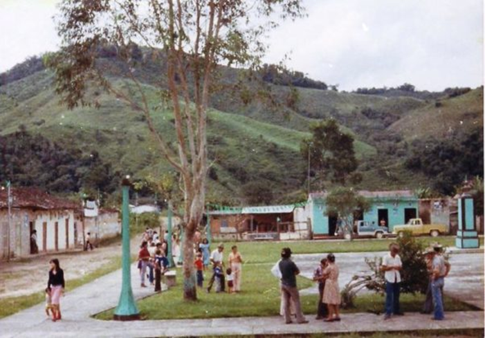
Fotografía de los años 70 que muestra cómo era la vida cotidiana de los pobladores del desaparecido pueblo Potosí, Venezuela. Fuente
Photo from the 70s showing what the daily life of the inhabitants of the defunct Potosí town, Venezuela was like. Source
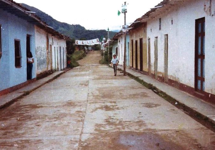
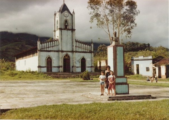
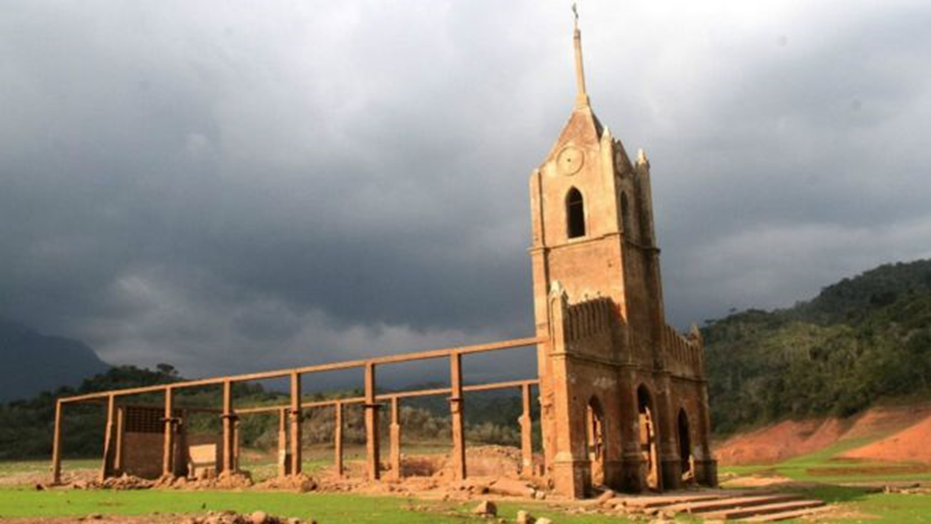
Esta es otra fotografía que reposa en los archivos de la Gobernación del Estado Táchira, Venezuela. Aquí se puede ver una de las calles del desaparecido pueblo venezolano Potosí. Podemos apreciar la arquitectura de las viviendas: casas humildes, típicas de la región andina. Predomina el barro en las paredes, la madera, techos de caña amarga y tejas de arcilla. puertas grandes de madera, ventanales hechos de madera doble paño. Esta calle formaba parte de las diagonales que conformaban la cuadrícula del pueblo en torno a la antigua Iglesia y la Plaza. Fuente
This is another photograph that rests in the archives of the Governorate of the State Táchira, Venezuela. Here you can see one of the streets of the defunct Venezuelan village Potosí. We can appreciate the architecture of the houses: humble houses, typical of the Andean region. Mud predominates on walls, wood, bitter cane ceilings and clay shingles. Large wooden doors, floor-to-ceiling windows made of double-clothed wood. This street was part of the diagonals that made up the grid of the village around the old Church and the Plaza. Source
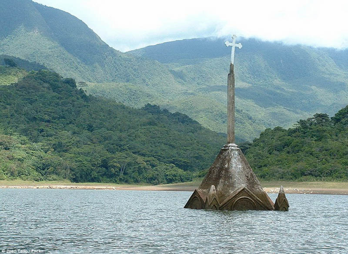
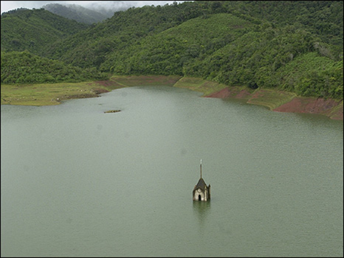
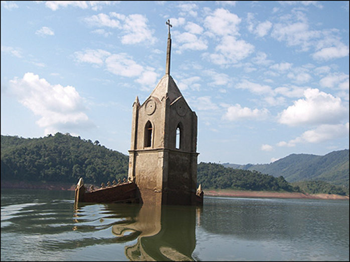
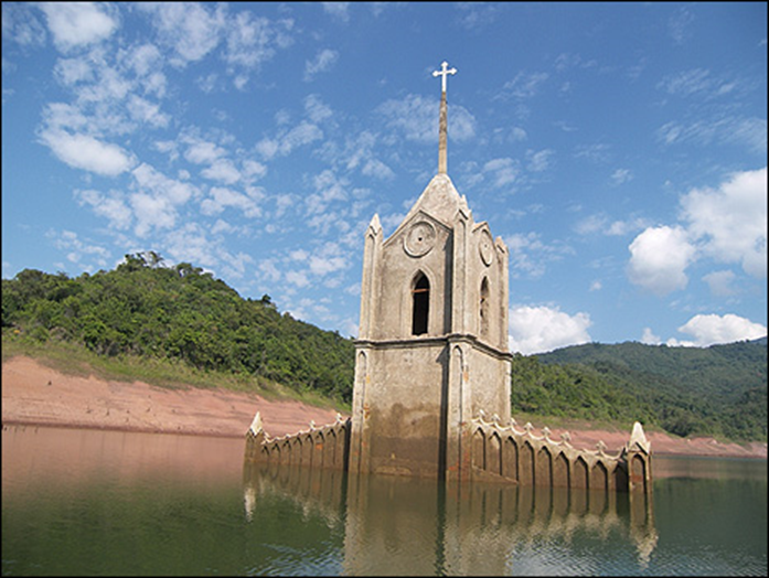
Lo interesante de la historia es que finalmente el pueblo quedó sumergido en las aguas, como lo habían predicho los expertos. Tras la construcción de la represa, los responsables del proyecto inundaron intencionalmente todo el lugar, pero desde 1998 hasta la fecha y por causa de los cambios climatológicos el pueblo ha emergido totalmente en varias oportunidades. Con la llegada del fenómeno climático “El Niño”, período de intensa sequía en Venezuela entre los años 2009 y 2010 y luego en el 2015 y el 2016, la cruz de la Iglesia quedó expuesta. Las aguas han venido bajando su nivel y nuevamente del antiguo pueblo se han podido fotografiar las ruinas, siendo la antigua Iglesia el mayor atractivo de interés turístico.
The interesting thing about the story is that the village was finally submerged in the waters, as the experts had predicted. Following the construction of the dam, project managers intentionally flooded the entire site, but from 1998 to date and due to weather changes the people have emerged fully on several occasions. With the advent of the climate phenomenon "El Niño", a period of intense drought in Venezuela between 2009 and 2010 and then in 2015 and 2016, the Cross of the Church was exposed. The waters have been lowering its level and again the old town has been able to photograph the ruins, with the old Church being the greatest attraction of tourist interest.
En el pasado reciente, antes que llegaran los llamados socialistas al poder, Venezuela era una potencia hidroeléctrica proveedora de electricidad a varios países de la región. Nuestra industria era fuerte, pujante y muy próspera, con tecnología de punta, en la actualidad da tristeza y mucho dolor ver el estado de abandono y deterioro en la que está. Los venezolanos estamos sufriendo bajones eléctricos y apagones constante por la decadencia del servicio. Se presume que la causa principal de tanto daño al País sea el modelo político retrógrado, arcaico y fracasado que se ha impuesto donde la corrupción y la no inversión ha jugado un papel preponderante en la destrucción del País, además la falta de personal humano calificado, la migración de personal profesional y técnico y el éxodo de la mano de obra preparada ha hecho que ho Venezuela esté en niveles de pauperización jamás vistos. La noticia mas reciente que se tiene del Complejo Hidroeléctrico Uribante Caparo, salió publicada en el Diario El Nacional, hace dos día, el pasado 22 de febrero de 2021, cuyo titular dice, cito: “10 horas diarias sin luz”, fin de la cita. Por constantes apagones en el Estado Táchira, además de frecuentes cortes de energía eléctrica. Jesús Salcedo, presidente de la organización política y educativa, Alianza del Lápiz, en el estado Táchira, denunció que los 29 municipios de la entidad andina son sometidos diariamente a cortes de energía eléctrica de al menos 10 horas.
In the recent past, before the so-called Socialists came to power, Venezuela was a hydroelectric power supply of electricity to several countries in the region. Our industry was strong, thriving and very prosperous, with state-of-the-art technology, today it gives sadness and a lot of pain to see the state of abandonment and deterioration in which it is. Venezuelans are suffering from electric power and constant blackouts because of the decline of service. It is presumed that the main cause of so much damage to the country is the retrograde, archaic and failed political model that has been imposed where corruption and non-investment have played a leading role in the destruction of the country, as well as the lack of skilled human personnel, the migration of professional and technical personnel and the exodus of the prepared workforce has made Ho Venezuela at levels of pauperization never seen before. The most recent news of the Uribante Caparo Hydroelectric Complex was published in the Newspaper El Nacional, two days ago, on February 22, 2021, whose headline says, quote: "10 hours a day without light", end of the appointment. For constant blackouts in the Táchira State, as well as frequent power outages. Jesús Salcedo, president of the political and educational organization, Alianza del Lápiz, in the state of Táchira, denounced that the 29 municipalities of the Andean entity are subjected daily to power outages of at least 10 hours.
It is disheartening to know that the entire town was submerged, that church must have reminded many about their ancestor's land and life. That is indeed tragic.
I really appreciate the entire truth about the dam's project being revealed through this post. Keep sharing and keep flourishing :) @marcosmilano71
Hello @ sahiba-rana I greet you from Venezuela. Yes, it was sad to see that beautiful place submerged in the waters and thirty years later nostalgia to see how it would emerge again ... Memories, many memories of what was one of the most beautiful Andean towns of the time of good. Working people. Thanks for your comment. Greetings and infinite blessings for you and your loved ones.
Open in Google Translate
While the whole story is fascinating, it is really distressing that this city got submerged.
Hello @antonireviewer I greet you with great respect from Venezuela. Thanks for your comment. Greetings and blessings to you and your loved ones.
Igualmente, compañero.
This is such an incredibly tragic story @marcosmilano71! I offer my heartfelt compassion and sympathy to the previous settlers of the village (town of Potosí, Venezuela) that got submerged due to the dam project's flooding. That church tower became the visible reminder of that destructive event plus the electrical blackouts were painful memories of the devastating effects of mishandling our natural resources. These would pretty much be warning signs from the heavens to stop abusing our immediate surroundings. What do you think?
Hello friend @storiesoferne Good morning from Venezuela. Thank you for your comment and for all the support you give to our humble posts. Thanks for your good wishes. The truth is that sooner or later the town was going to be flooded due to the location downstream and in the valley area where it was built, as the experts warned. Taking this aspect into consideration, the Engineers and Architects of the old Venezuelan electricity company, Compañía Anónima de Administración y Fomento Eléctrico (CADAFE), today called the National Electric Corporation (CORPOELEC) presented a magnificent project for the Uribante Caparo Hydroelectric Complex. In 1984 the government managed to convince the residents to leave the place because the works were already advanced and for that reason they were evicted. Today there are many families who lived in Potosí and who today look with nostalgia at the ruins of their ancient town. Those who knew the place assure that it was very beautiful, good and hard-working people. The story is fascinating but sad. However, the positive side was the electrical development of my country which today is in frank deterioration. Thanks friend, Greetings and blessings.
Thank you so much, my friend! Have a wonderful day!
The Architecture+Design Community is an Active Member of the
OCD Communities Incubation Program
Intersante historia y muy instructivo, gracias por compartir.
Good afternoon from Venezuela. Thanks to you @comandoyeya for your comment. Greetings and blessings to you and to your loved ones.
Amen y adelante, siempre positivo, saludos
Es una historia muy interesante, entonces el pueblo desapareció, el nombre también se perdió o trasladaron a los habitantes a un lugar donde también lo llamaron Potosí?
Good evening @cryptoxicate Yes, the town does not exist. The government of the time (beginning of the 80s) managed to convince all its inhabitants by giving them houses, which facilitated the eviction. In 1984 the town was completely evicted. Many inhabitants moved to neighboring towns and Potosí (Venezuelan) remained in the memory, totally submerged for more than 30 years until it re-emerged due to the intense period of seqjuía that hit Venezuela.
Es una historia fascinante y a la vez triste, se perdieron años de avance debido al mal uso de fondos. Espero que todo mejore, un saludo @marcosmilano71
Hello @cryptoxicate Greetings from Venezuela. Yes it is. Unfortunately we have regressed. Thank you for your comment. Greetings and infinite blessings.
Amezing pitchers 👌👌
However sad that the whole village was submerged, it's quite a relief that the foreseen events of flooding resulted in creating a project that would evict the residents, thus preventing any loss of life. It must have been nostalgic and sad to see the condition of the Potosi village when it resurfaced again due to El Nino. I hope things get better with the blackouts. Sending you and your family prayers and positive wishes.
Amen. Amen. Amen. Hello Friend @discoveringarni. Yes, a lot of nostalgia and yes, thank God a greater tragedy was avoided. This area is located downstream, many tributaries are born at the head of the mountains that converge in the great Uribante rivers and the Caparo river. In times of intense rain, floods are dangerous, for that reason the Hydroelectric Complex was built to take advantage of the power of the waters and transform it into electrical energy that feeds the entire region and part of Norte de Santander in Colombia. At this moment the electricity fails quite a bit. Thanks for your comment. Greetings and infinite blessings for you and your loved ones.
With your permission, I am going to leave you a short video where the first part of the translation says the following:
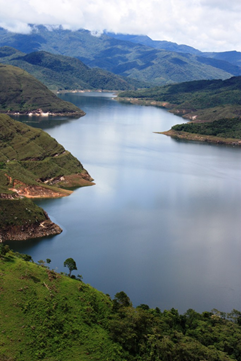
Uribante, Municipality of tourism and energy. Uribante and its surroundings. The Uribante Municipality has a land area of 1502 square kilometers, represents 13.4% of the State of Táchira and therefore constitutes the largest municipal entity in the territorial geography. The water sources are one of the most important riches of the Uribante Municipality, its surroundings are full of mountain landscapes, steep slopes, broken relief, small waterfalls, streams and streams that will eventually become individual tributaries of the important Uribante River. The Uribante is the main watercourse in the Táchira State due to its flow, extension, length and numerous tributaries. This important river is born in Templades at an altitude of 3400 meters above sea level and on its way it is fed by the Pedernales, Penegas, Negro and Puyas rivers in addition to numerous individual tributaries, its hydroelectric potential is reached downstream of the town of Pregoneros when the river is dammed in the La Honda reservoir of the Uribante Caparo Hydroelectric Complex. Then the video shows you the town of Pregonero and finally the La Honda Dam Reservoir.
Thank you for sharing the video and blessings to you and your family
Wow se ve que es un lugar de mucho valor social, gracias por compartir.