When I began this series of articles, I made a number of assumptions about how Claudius Ptolemy compiled his description of Ireland—Geography, Book 2, Chapter 2. It is now time to revisit those assumptions in the light of my research over the past two-and-a-half years.
Ptolemy’s Source
As I have reiterated many times in the course of this series, I accept T F O’Rahilly’s assertion that Ptolemy’s principal source of geographical information on Ireland was Pytheas of Massalia, a Greek explorer who is believed to have visited Ireland and Britain around 325 BCE.
More than seventy years ago O’Rahilly pointed out that Ptolemy’s specific information on Ireland, when compared with his data for Britain, was several centuries out of date. For example, there is no trace in Ptolemy’s Geography of two of the principle Celtic races of Ireland, the Lagin and the Goidel, who had certainly colonized the island by Ptolemy’s time. 325 BCE was sufficiently early to have preceded both the Laginian and the Goidelic settlers:
... the most striking feature of Ptolemy’s account of Ireland is its antiquity. The Ireland it describes is an Ireland dominated by the Érainn, and on which neither the Laginian invaders nor the Goidels have as yet set foot. The language spoken in it was Celtic of the Brittonic type (p. 17). (O’Rahilly 39-40)
While the evidence of the names in Ptolemy’s account of Ireland shows plainly that the Ireland he describes was a Celtic-speaking Ireland, none of the names has anything peculiarly Goidelic about its form. On the contrary, there is positive evidence to show that the Celtic spoken in Ptolemy’s Ireland was of the Brittonic type. (O’Rahilly 17)
Ptolemy’s description of Britain includes several references to the Dumnonii (2:3:2, 2:3:7, 2:3:8, 2:3:13), who were closely related to the Laginians, and may even have colonized parts of Britain from Ireland (O’Rahilly 93-94, 130). There is clearly a disparity between Ptolemy’s sources for Britain and his sources for Ireland.
O’Rahilly’s reasoning is indefeasible, and in the seventy-odd years since the publication of his Early Irish History and Mythology no one has refuted his claim. Nevertheless, most scholars who have come after him have simply ignored what he had to say about Ptolemy’s sources. Such scholars generally surmise that Ptolemy relied upon recent geographers for his information on Ireland. For example:
Ptolemy tells us it was reasonable to use locations “obtained through the more accurate [ie astronomical] observations, as foundations, so to speak, but to fit [the features] that come from the other [kinds of data] to these ... The “other kinds of data” are traveller, merchant and military reports of distances and directions collected by previous geographers, notably Marinus of Tyre ... Ptolemy’s map of Ireland is a long exposure photograph in the sense that it most likely represents points recorded not instantaneously but over time, written down and fixed at roughly AD 100. Ptolemy references 15 rivers, six promontories and ten cities. He names and gives the proximate locations of 16 tribes ... Of Ptolemy’s specific information on Ireland, or its sources, we know nothing. (Darcy & Flynn 50)
The question is finally considered from which earlier authorities the detailed geographical information in Ptolemy, Geography II 2 is derived and the conclusion is put forward as probable that very little of Pytheas survives whereas the mass of the material comes from Philemon who derived his information from contemporary merchants belonging to the islands or the adjacent continental area. (Tierney 257)
Ptolemy certainly drew upon Marinus (early 2nd century CE) and Philemon (early 1st century CE) in compiling his Geography, but if either of these geographers was a source for Ireland, Ptolemy’s description of Ireland would not lack all mention of the Lagin or Goidels.
Philip Freeman unwittingly provides some support for O’Rahilly when he notes the inaccuracy of Ptolemy’s east coast, which should be the most accurate if Ptolemy was basing his description on contemporary Roman sources:
On the whole, Ptolemy’s portrayal of Ireland is reasonably accurate given the island’s distant location on the edge of the known world ... The generally southwestern bulge of Kerry and the northeastern protrusion of Ulster are both shown, as is the southeastern cape near Wexford. The western extension of Connemara is poorly indicated, but this would likely be the area least visited by merchants from Gaul or Britain. The eastern shore, however, is less accurately drawn than we might expect for the coast presumably most visited by Roman merchants. (Freeman 68-69)
Ptolemy the Armchair Theorist
Claudius Ptolemy was a theoretician, not a practitioner. He did not travel the World in order to collect data on distant countries. He did not consult merchants and other contemporaries for his Geography. He simply went into the Library at Alexandria and did his research. For places in the Roman Empire, he probably found up-to-date contemporary accounts. But for Ireland, Pytheas’ account was probably the only significant one he found, so he used it. He never attempted to update it.
There is nothing new in this description of Ptolemy and his modus operandi. In 1977, Robert Russell Newton made the case for the prosecution in The Crime of Claudius Ptolemy. One review of Newton’s book sums up his argument in the following words:
To Johns Hopkins physicist Newton, the Alexandrian sage is “the most successful fraud in the history of science.” The astronomer’s reputation had already come under attack as a result of allegations by Nicolaus Copernicus in his widely publicized De revolutionibus (1543). Now Newton’s meticulously documented study reveals that Ptolemy faked astronomical data, worked backwards from results he was trying to prove, and claimed to have made observations that could not have been made from Alexandria. His models of the moon and Mercury “conflict violently with elementary observation.” Newton’s conclusion: Astronomy would be better off if Ptolemy’s Syntaxis [Almagest] had never been written. (Wilson Quarterly Archives)
Not everyone accepts Newton’s verdict, but even some of Ptolemy’s adherents concede that many of the “observations” recorded in the Almagest were “corrected” to better fit the theory (Gingerich 263).
I believe that Ptolemy may also have “corrected”, or even fabricated, many of the coordinates (latitudes and longitudes) quoted in his Geography in order to match his preconceived ideas of the sizes and shapes of various countries—including Ireland.
Ptolemy and Marinus of Tyre
It is generally accepted that Ptolemy’s Geography was inspired by the work of Marinus of Tyre:
The source on which he especially relies is the geographer Marinus of Tyre, to the point that the Geography in many ways seems an expansion and correction of the previous work of Marinus. Unfortunately, the original work of Marinus does not survive, and we know nothing of this writer aside from the comments of Ptolemy in his Introduction. We do not even know exactly when Marinus lived, though he cannot have written long before the composition of the Geography, as Ptolemy calls him the latest of the geographers ‘‘of our time’’ [Geography 1:6]. Ptolemy clearly has the greatest respect for Marinus’ work, yet he feels the need to correct many of his predecessor’s errors. As related by Ptolemy, Marinus carefully surveyed the writings of earlier geographers and historians, and drew as well upon the first-hand accounts of many travelers. These accounts include voyages of Greek sailors to India, Roman expeditions to Africa, voyages to the Canary Islands, and Macedonian merchant expeditions to central Asia and China [Geography 1:7-11]. Marinus does complain that merchants are generally not the most reliable sources for geographic information ... (Freeman 66)
In compiling his map of Ireland, what did Ptolemy inherit from Marinus? I believe that we can formulate a hypothesis based on a few well-known facts:
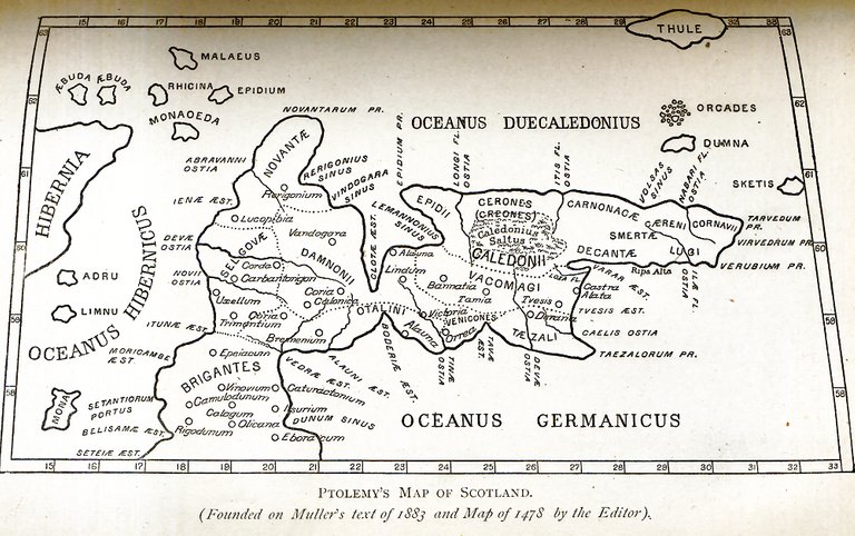
- Ptolemy’s map of Scotland is on its side:
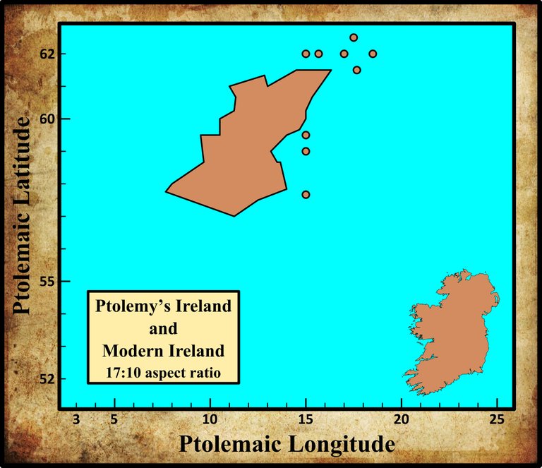
- Ptolemy’s Ireland is placed too far to the north in relation to Britain:
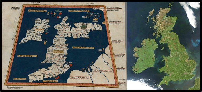
- Ptolemy’s Ireland is placed to the northwest of its true location and is much bigger than its actual size:
On reference to the accompanying map it will be seen that the outline of what we call England bears a very recognisable general resemblance to that of the country as now known. But instead of Scotland appearing, as it ought to do, as a continuation of England towards the north, it is twisted round sharply to the east. Ptolemy’s map of North Britain, in fact, looks like a map of Scotland turned over on its side ...
My own hypothesis in explanation of Ptolemy’s mistake is, that either he or one of his predecessors had before him three sectional maps, representing severally what we call England [and Wales], Scotland, and Ireland, and drawn approximately to scale, but without meridians or parallels. It was no doubt then, as now, usual for a map to be enclosed in a rectangular frame, with sides towards the four cardinal points. In fitting the three maps together, Ptolemy (or his predecessor) fell into the mistake of turning the oblong map of Scotland the wrong way. I think it is even possible to discover the process by which he was led astray. From some cause, he had assigned to Ireland a latitude so much too high that if he had given to the map of Scotland its proper orientation, a portion of that country must have fallen right across the western island. (Bradley 382-383)
Following Bradley’s line of reasoning, I would surmise that when Ptolemy came to create his map of Ireland, he was armed with a basic outline of the country (showing only its size and shape), which he took from Marinus, and a catalogue of geographical features (headlands, river mouths, coastal settlements, and inland settlements), which he took from Pytheas. He then simply fitted these two sources together as best he could.
Pytheas’s catalogue was probably a periplus: an ordered list of ports and coastal features, with the distances between them and, possibly, some rough bearings. Pytheas is unlikely to have included latitudes, however. That would have required him to measure the altitude of the celestial pole, but Ptolemy tells us explicitly that Hipparchus, who flourished almost two centuries after Pytheas, was his only source for altitudes of the pole:
But Hipparchus alone has handed down to us the altitudes of the pole—but only for a few of the many cities that are required for a world map—and also lists of cities that lie on the same parallel. (Ptolemy 1:4, Müller 12)
Ptolemy’s description of Ireland also includes a list of seven inland “cities”, so Pytheas’s account may also have included an itinerary of inland settlements. Again, this is unlikely to have included more than an ordered list of settlements with the distances between them, and perhaps some rough bearings.
Correcting Ptolemy’s Coordinates
If Pytheas was Ptolemy’s principal source of information on Ireland, and if Pytheas’s account did not assign specific coordinates to any geographical features, then where did all those latitudes and longitudes in the Geography 2:2 come from?
In my opinion, Ptolemy simply made them up in order to achieve a best fit between Marinus’s map of Ireland and Pytheas’s account (periplus and itinerary). For this reason, I believe that any attempt to identify the features of Ptolemy’s Ireland based on their coordinates is unlikely to be successful. Also, any attempt to “correct” Ptolemy’s coordinates by applying some mathematical algorithm to them is equally flawed.
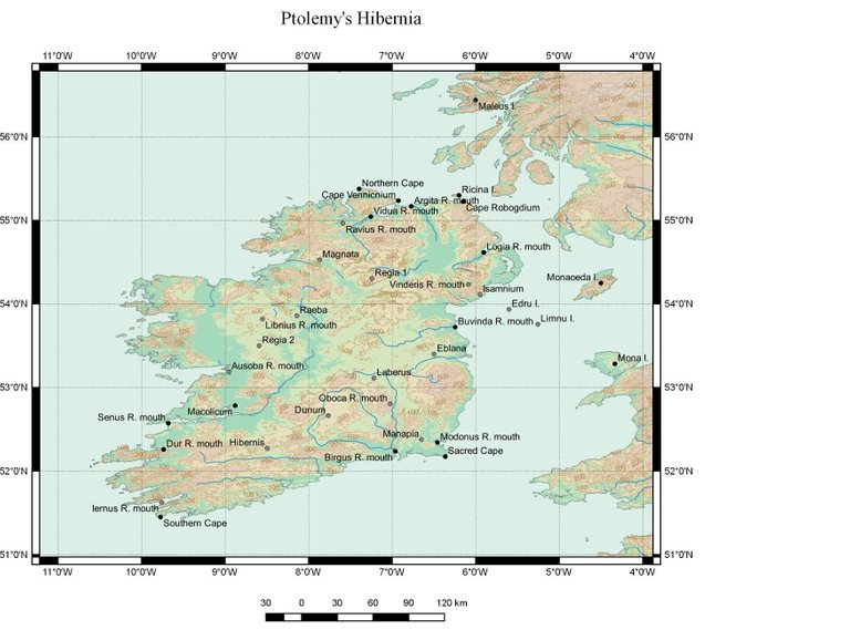
Of course, many attempts have been made over the years to correct Ptolemy’s map of Ireland by applying some such algorithm to the coordinates, but they have all had their flaws. In 2008 Robert Darcy and William Flynn adjusted Ptolemy’s latitudes and longitudes using fairly simple formulas, but this led them to make a few blunders in their identifications:
Darcy and Flynn (2008) used a relatively primitive mathematical method to produce their digital reconstruction of Ptolemy’s Hibernia, which, in absence of a sound statistical analysis of the errors involved, led them to such surprising mistakes as their misidentification of the River Shannon as Ptolemy’s Dur (Duris) River, instead of the nearly universally accepted Senus River. Hickson (1894) spotted survival of the Irish name Bun-abhainn-dur ‘end of the river Dur’ on the River Lee estuary near Derrymore, a rural district of County Kerry, so we have no doubt as to the true identities of the Senus and Dur rivers. (Abshire et al 4)
That Ptolemy’s Sēnos is the River Shannon is one of only a handful of identifications of which one can be absolutely confident. Any algorithm that contradicts this identification cannot possibly have any validity. Having said that, many of Darcy & Flynn’s identifications are unimpeachable.
Abshire et al, whose criticism of Darcy & Flynn is quoted above, applied a more sophisticated algorithm of their own, but their results are frequently bizarre:
Several river mouths (Oboka, Vinderis, Libnios) are relocated inland.
Several coastal settlements (Eblana, Nagnata, Manapia) are relocated inland.
Unfortunately, the authors do not discuss or defend these anomalies:
In Hibernia, Camden (1607 [pp 1356-57]) identified Ptolemy’s Raeba as Castlereban, the site of the medieval barony of Rheban, featuring remnants of a castle and a nearby moat. However, our triangulation and flocking algorithms point at locations within 13 to 42 km from Rathcroghan, a complex of archaeological sites identified as Cruachan, the ancient capital of the Connachta, approximately 120 km away from Castlereban.
The limitations imposed on the size of this paper do not allow us to discuss more examples of identifications. (Abshire et al 5)
In an earlier article, I hypothesized that Ptolemy’s Rhaiba referred to the Hill of Uisneach, in the centre of Ireland.
References
- Corey Abshire, Anthony Durham, Dmitri A. Gusev, Sergey K. Stafeyevd, Ptolemy’s Britain and Ireland: A New Digital Reconstruction, Proceedings of the International Cartographic Association, Volume 1, Copernicus Publications, Online (2018)
- Henry Bradley, Ptolemy’s Geography of the British Isles, Archæologia, Volume 48, Issue 2, pp 379-396, Cambridge University Press, Cambridge (1885)
- William Camden, Britannia: Or A Chorographical Description of Great Britain and Ireland, Together with the Adjacent Islands, Second Edition, Volume 2, Edmund Gibson, London (1722)
- Robert Darcy & William Flynn, Ptolemy’s Map of Ireland: A Modern Decoding, Irish Geography, Volume 41, Number 1, pp 49-69, Geographical Society of Ireland, Taylor and Francis, Routledge, Abingdon (2008)
- Owen Gingerich, Was Ptolemy a Fraud?, Quarterly Journal of the Royal Astronomical Society, Volume 21, pp 253-266, Blackwell Scientific Publications, London (1980)
- Hickson, The River Lee of Kerry: Its True Course, and Its Identity with the Dur of Ptolemy, The Journal of the Royal Society of Antiquaries of Ireland, Fifth Series, Volume 6, Number 2 (July 1896), pp 173-175, Dublin (1896)
- Karl Wilhelm Ludwig Müller (editor & translator), Klaudiou Ptolemaiou Geographike Hyphegesis (Claudii Ptolemæi Geographia), Volume 1, Alfredo Firmin Didot, Paris (1883)
- Robert Russell Newton, The Crime of Claudius Ptolemy, The Johns Hopkins University Press, Baltimore, Maryland (1977)
- Karl Friedrich August Nobbe, Claudii Ptolemaei Geographia, Volume 1, Karl Tauchnitz, Leipzig (1845)
- Karl Friedrich August Nobbe, Claudii Ptolemaei Geographia, Volume 2, Karl Tauchnitz, Leipzig (1845)
- Thomas F O’Rahilly, Early Irish History and Mythology, Dublin Institute for Advanced Studies, Dublin (1946, 1984)
- Claudius Ptolemaeus, Geography, Biblioteca Apostolica Vaticana, Vat Gr 191, fol 127-172 (Ireland: 138v–139r)
- J J Tierney, The Greek Geographic Tradition and Ptolemy’s Evidence for Irish Geography, Proceedings of the Royal Irish Academy: Archaeology, Culture, History, Literature, Volume 76, pp 257-265, Royal Irish Academy, Dublin (1976)
- Friedrich Wilhelm Wilberg, Claudii Ptolemaei Geographiae, Libri Octo: Graece et Latine ad Codicum Manu Scriptorum Fidem Edidit Frid. Guil. Wilberg, Essendiae Sumptibus et Typis G.D. Baedeker, Essen (1838)
Image Credits
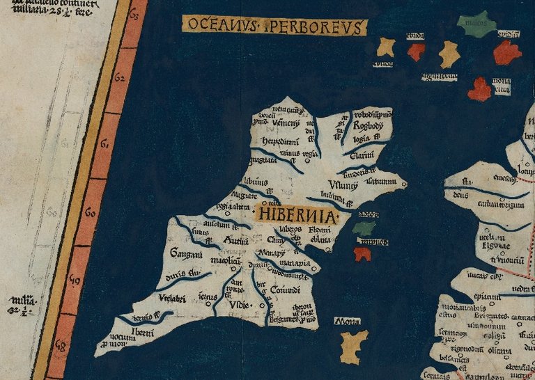
- Ptolemy’s Map of Ireland: Wikimedia Commons, Nicholaus Germanus (cartographer), Public Domain
- T F O’Rahilly: Copyright Unknown, Fair Use
- Ptolemy’s Map of Scotland (After Müller): William F Skene, Alexander MacBain (editor), The Highlanders of Scotland, Eneas MacKay, Stirling (1902), Public Domain
- Ptolemy’s Pretannic Isles and Modern Britain & Ireland: Jeff Schmaltz, MODIS Land Rapid Response Team, NASA GSFC (Goddard Space Flight Center), Public Domain
- Ptolemy’s Ireland (Abshire et al): © 2018 Abshire et al, Creative Commons License

This post was shared in the Curation Collective Discord community for curators, and upvoted and resteemed by the @c-squared community account after manual review.
@c-squared runs a community witness. Please consider using one of your witness votes on us here