It was always interesting for me to see my hometown from an airplane, but the dream did not come true, since the planes did not fly out of Magadan, but from the village of Sokol. In view of the rare flights, sometimes with a break of up to a decade, the prospect to view from such a height Magadan and native hills was reduced to zero. But my travels happen quite unexpectedly, often even for myself. I was sitting in Moscow, pored over the album and the site and then on you! We must fly to Magadan, right tomorrow! Taking a head start for a day, to settle urgent matters at the location, I collected some simple photo and video supports, handed over the layout of the album version of the album to print and went to Magadan.
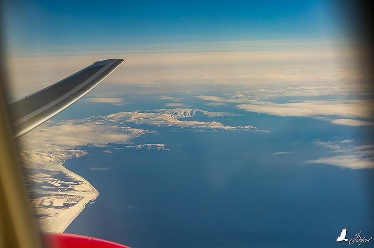
So, in the return flight, I decided not to fake and enlist the support of the airline staff in order to get permission to shoot on board. Thanks to this support, I had a little more freedom of movement and could take pictures from the right and left sides of the aircraft. Hoping to see again the Bolshaya Anngachak Ridge, the Kolyma Reservoir and the familiar rivers and mountains of the beloved Magadan Region, I settled in the shadow part of the aircraft, but something went wrong. The plane obviously went a little to the south, I could not find out the terrain, although I understood that it was my Kolyma. To clarify the situation, I moved to the left side and was surprised by what he saw. I saw the Staritsky peninsula, on which my city stands, as well as the Island of Misunderstanding! I take a camera, put a telephoto lens on it and literally, under the wing of the plane, I examined my city. He moved GoPro to another porthole to remove the time-lapse from the left side. I will repeat this picture again with the frame.

In this picture, almost all of my memories of underwater adventures over the past 3 years. Here, on the left, at the border of the frame, is the Salty Lake, the nearby coastal zone, I rested upon holding my breath in search of a colony of sea urchins. An island of Misunderstanding with its lush anemone gardens. Ostrovnaya Cape, Nagaeva Bay, Cape Chirikov, Svetlaya Bay and Eagle Bay - where he could, dived everywhere. And these hills! How many weeks spent on them with a camera over the past 14 years! I even see my dear Berezovy, where I once decided to become a professional photographer. And here is a view from this magnificent place. I have come here since 2000 and I never got tired of it. It seems here as something special. Often I stayed here for more than a week.

From Berezovy in clear weather Spafarev Island can be seen. I have long been dreaming of visiting this island in order to conduct there a detailed photographing from the air, on the ground and under water. In general, to do everything that I can do best and really love.

My plane flew along the coast of the Sea of Okhotsk and soon I saw Spafarev Island from the air! How beautiful he is! How do you want to organize a photo expedition here! This island is worth it! I photographed it with a telephoto lens. To this island from my city to go only 100 km by sea. A smaller island is visible below - this is Talan Island, here is the largest colony of seabirds. Dream birdwatchers.

Dreaming about new travels and looking out for interesting places I used to google maps I often looked at Motykleysky Bay, this amazing place is famous for its healing hot springs and beauty. I did not think that I would see everything with my own eyes and show you more. To be here with a photo expedition, for me it’s all the same what to remove a star from the sky. Happiness and good luck. Taking this opportunity, I took a panorama of these places from an airplane. On the left below Cape Onatsevich, it is clearly visible at sunset from my city and looks like an orange mirage. On the right, bound by an ice shell, Motikles Bay. From this unique place to the nearest village about 50 km, but the road is long gone. Above the bay, looking like a crooked crab claw - Hmetevsky peninsula. A picturesque place, judging by the relief, must also be visited.
![[Group-0]-_MLR1780__MLR1790-11-images.jpg](https://images.hive.blog/768x0/https://ipfs.busy.org/ipfs/QmScUqRDURf1pMea7QwHYkREj3aATVDo1kaocRLN5i88Se)
Further, in the course of the flight, immediately after a sharp cape called Dalny, Shelting Bay opens. Entirely, it fit only 24 mm. Big and interesting. Free of ice, he still interested me in his underwater kingdom, something there is worthy of attention. Roads there chtoli, and maybe power lines. How interesting!

On the right, the bay of Shelting is closed by a peninsula with a name similar to the Japanese name - Onar. The highest point of the peninsula - Mount Dry (1046 meters).

For a more complete picture took more panorama. Behind the Onar peninsula, belted by the horseshoe of the Chutkavar mountains, between the capes of Moskvitin and Izmaylova is Luzhin bay. The depths in this bay are considerable, at the coast 10, in the middle of 20-37, and to the sea all 50 meters. Maybe there is a good halibut caught? The Far East is so beautiful and rich, but it keeps on a continuous optimism!
![[Group-2]-_MLR1819__MLR1820-2-images.jpg](https://images.hive.blog/768x0/https://ipfs.busy.org/ipfs/QmcZHUHU3c31nVKHKVzcyUJB4z1fSkMX7M3HpXb7pD13U9)
The Far East of Russia is very rich in all sorts of names, almost every stream or mound has its own name. For example, Cape Orlik, or Bear, Coal. Full of all sorts of romantic names. But the continuation of the Chutkavar mountains, I liked them very much and with their circuses reminded the mountains of the Koni peninsula. And what a picturesque valley goes into a small cozy cove! Beauty! The stream that flows through this valley is called - Mountain. I would walk along the valley of this stream to the very top of the Ploskaya mountain, which is 1296 meters high. It is in front of these pointed tops, on the left, that the invisible border of the Magadan Region and the Khabarovsk Territory runs. All vertices have names. The one that by the sea is already Ploskaja Mountain, the next one that is closer to us is the Orient Mountain, 1106 meters high. And the third peak is Mount Ostraya, 1179 meters high.
![[Group-3]-_MLR1836__MLR1843-8-images.jpg](https://images.hive.blog/768x0/https://ipfs.busy.org/ipfs/QmYTqtTeHKAfM4w3ubk92qcQYJHBHsmJZsP1ZydU8DHJjt)
The mountain stream flows into a nameless cove between the Rusty and Black mountains.

Well, and further, enchanting eyes of the photographer and diver - the Bay of Ushki and the Lisyansky peninsula (named after the Russian navigator and explorer Yury F. Lisyansky). They are insanely beautiful!

A strongly indented coastline with an abundance of small coves with clear water is the dream of every diver, and even more so a photo frame! There is an abandoned meteorological station on the Lisyansky Peninsula, I suppose that there is some kind of farm there. Noteworthy is the two-headed mountain right in the center of the peninsula, its height is 1211 meters, and its name is Hadacha. What makes her interesting? And there are two circuses, one of which is a beautiful mountain lake.

Lisyansky Peninsula divides the Gulf of Ushki and the Eirin Bay. There are two bays in the Eirineysky Bay, in the right, in the Malaya Molta Bay is the Eirineysky Fish Factory. Of course, he was abandoned, and to the left, in the Bolshaya Molta Bay, was the house. Maybe there someone else lives in the season of the fishing season? Places, of course, cause a great desire to make a trip here. Further, Cape Shilkan and the Horsenaya Bay stuck in the ice, where the map indicates the group of non-residential huts and the fish factory No. 12.

After Cape Gadikan, covering Shilka Bay, at the mouth of the Alaglya River stands the abandoned settlement of Shilki.

Shilki almost at the side of the settlements of Inya and New Inya. There, people still live, and can survive. These villages, below, to the right of the numerous channels of the Yin River. Can not see? So they live, invisible by no one, on the left, the abandoned settlement of Khariuzovka, and on the right the settlements of Yin. Even some field is seen.

Now I will show you closer.

And still further abandoned village Ulbeya and still alive Okhotsk and Vostretsovo.

Our plane took more and more to the North, and the coast stretched to the South. I watched my native land and my beloved sea, to which I hope so soon to return to tell about it again.

I am very grateful to the entire crew and staff of the airline for such a happy opportunity to photograph the beauty of this world. Special thanks to Julia’s stewardess who helped me clean the windows so that I could shoot through the clean windows. People often stick their heads at the windows and leave greasy stains on the glass :).


After the shooting and lunch, as always, I could not sleep and, as the mentors advised, set to work. It works in the sky in a special way.
Alexey Voron.
This post was shared in the Curation Collective Discord community for curators, and upvoted and resteemed by the @c-squared community account after manual review.
@c-squared runs a community witness. Please consider using one of your witness votes on us here
What amazing pictures and amazing flight crew to help you clean the windows! I was going to saw I couldn’t believe those were shot through airplane windows but the fact that they were cleaned before hand explains it. Lovely work!
Posted using Partiko iOS
Thank you very much! We tried our best!
You have wonderful passion for the land and scenery of your home. I'm glad you were able to capture it from above.
Thank you! :)
It took you a lot of efforts for capturing these amazing clicks of your hometown and of course thanks to Julia who helped you for getting more clear pictures. Nice clicks @alexeyvoron
Posted using Partiko Android