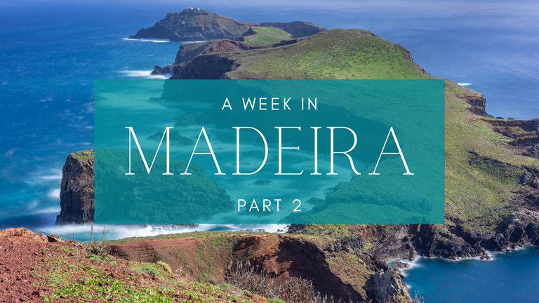
Hello Hivers, how are you? As promised, I'm back with part 2 of my travel itinerary from Madeira. If you haven't read part 1, you can read it HERE.
As I mentioned before, Madeira has it all. We've been to a laurel forest, levada walk in the village of Prazeres, and had good coffee and fun in Funchal or Praia Formosa. Now it's time to dive into part two. Are you ready?
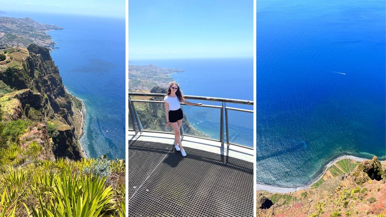
Day 5: Camara de Lobos
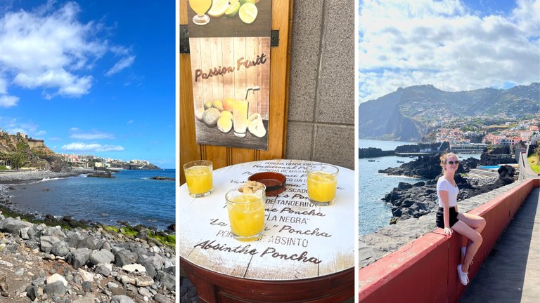
It was finally time to visit the magnificent cliff of Cabo Girao! It is probably the second highest in Europe (580 m) and offers an unbelievable view. My mom was surprisingly fine, considering the fact that there was so much space between her and the sea below, and the skywalk had a see-through floor. The entrance to the skywalk is 2€ and is so worth it!
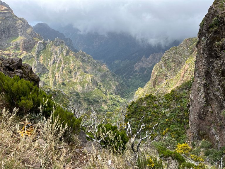
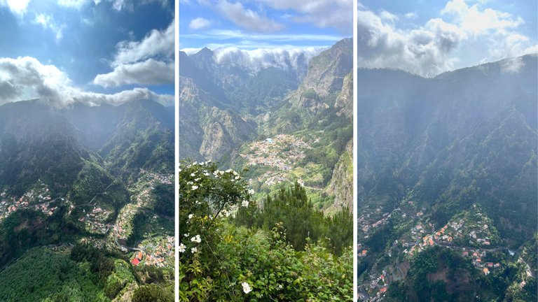
Another vertigo-inducing experience was the Eira do Serrado viewpoint. To get there, you take a very narrow road built into a vertical rock, and I was glad we came there quite late in the afternoon as there weren’t any cars on the road. I can’t imagine what it’s like in there during tourist rush hour. But the views? Oh. My. God. I’ve seen many breathtaking views in different places around the world. Still, this one, the view of the Curral das Freiras Valley, was the first one to make me happy cry about how absolutely amazing it was and how lucky I was to be there.
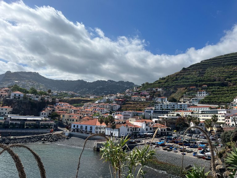
Both of these amazing places belong to the municipality of Camara de Lobos: a fishermen’s town on the island’s southern shore. The town itself is quite small, located in a cove with a non-typical lighthouse, with a magnificent cliff and steep mountains above. The town is known to be the origin of poncha: a local, very strong alcoholic mixed drink. It is usually made of local liquor or white rum, sugar cane, sometimes honey, and lemon juice. The ratio of the rum and juice is around 50:50, so you can imagine the power of the drink. From Praia Formosa, it’s a great evening walk to Camara de Lobos via the promenade by the ocean.
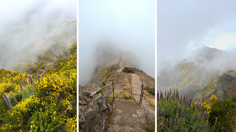
Day 6: Vereda do Arieiro
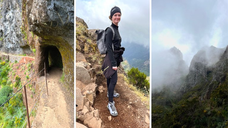
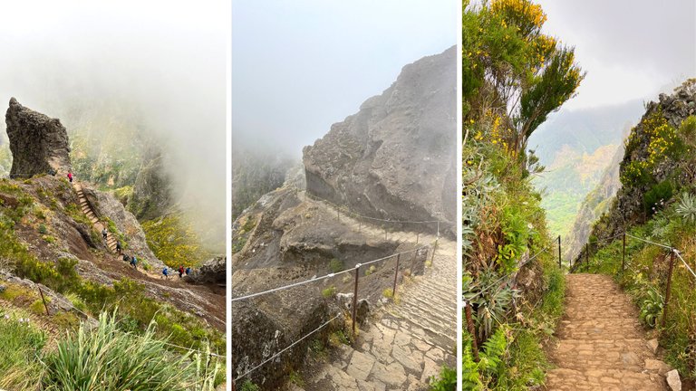
It wouldn’t be a proper visit to Madeira without hiking its most famous trail! Vereda do Arieiro, as it is called, is a 6 km trail connecting the island’s highest peaks: Pico do Arieiro & Pico Ruivo (plus Pico Das Torres, which you don’t climb but move on the slopes of).
The hike is quite demanding as its elevation changes are crazy. From Pico do Arieiro standing at 1810 meters, you take hundreds of steps all the way down to around 1450 meters, just to climb back to over 1800 meters to Pico Ruivo. Depending on your physical condition, it can take you anywhere between 2 and 5 hours to get from one peak to the other.
Getting there can be a little complicated as there is no public transport. You might want to book private transport or a taxi or find a group of people to rent a car with. You can drive all the way up to Pico Arieiro, but there is no way to reach Pico Ruivo by car. And it’s also very difficult to walk there and back in one day. So what’s the best setting, you might ask? I recommend having somebody drop you off at Pico do Arieiro and pick you up at Achada do Teixeira, the parking closest to Pico Ruivo.
I did just that, as my parents didn’t feel like hiking the whole trail. We parked at Pico do Arieiro (make sure to come early in the morning; otherwise, you might have nowhere to park), then walked a little together. Then, while my parents returned to the car and drove to Achada do Teixeira, I continued on the path. Then they parked again and hiked a little up to meet me on the slopes of Pico Ruivo.
The trail must also be one of my most beautiful hikes, except I’m not entirely sure. We were still quite unlucky with the weather, and the peaks hid in the clouds all day. I needed to descend all those stairs to find myself below the cloud and see something, and hence missed the most beautiful views at Pico do Arieiro, where the path goes on the mountain ridge with deep abysses on both sides. At least I have more motivation to come and hike again.
But I can be sure of this: the path is very attractive nonetheless and goes through multiple tunnels where it’s completely dark. It is very popular among tourists and can be dangerous sometimes, especially when it rains. I encountered a tiny landslide where a bunch of small rocks fell just a few steps before me, and it wasn’t even raining. So be careful and respect the closure of this trail when the authorities decide it’s not safe.
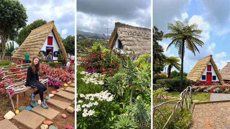
Since the road from Achada do Teixeira goes through the town of Santana, my parents and I stopped there to see the typical houses. I’m sure you’ve seen the colorful buildings on the internet already: they are very pretty. But to my surprise, there were only 4 or 5 of them! I expected it to be a village, and it was barely a half-street, but it was very pretty nonetheless. And they sold great poncha there.
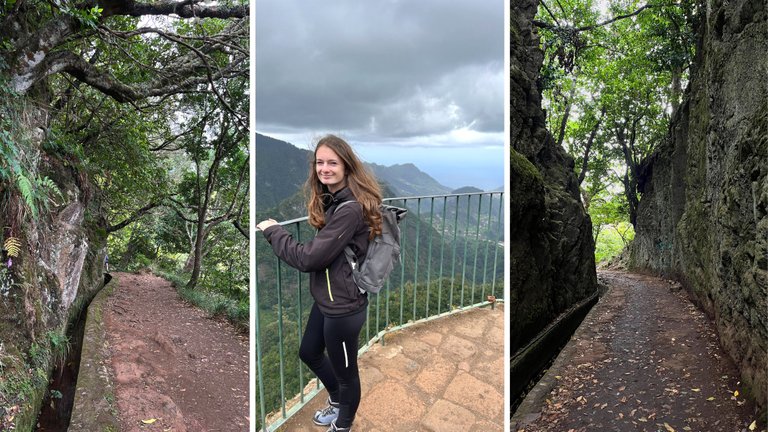
We were done in a few minutes in Santana, and it was still quite early, so we decided to do one more short hike (if you’re wondering if I’m crazy, I might be). We drove to the village of Ribeiro Frio to take a walk through a laurel forest (which very much reminded me of the Anaga mountains in Tenerife) called Vereda Dos Balcoes. Had the weather been a little better, we might’ve seen the peaks I had climbed a few hours before, but they were still hiding in the clouds. But we didn’t mind much; it was beautiful anyway.
Day 7: Ponta de Sao Lourenco
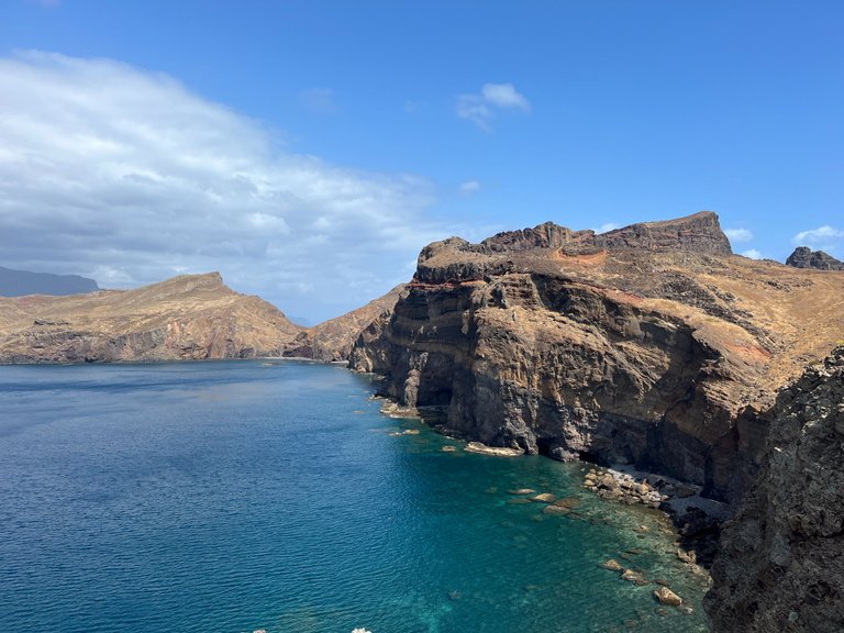
On the last day of our car rental, we went hiking at Ponta de Sao Lourenco in the east of the island. If you look at the map of Madeira, it looks kinda funny: the whole island seems quite compact, except for this Ponta reaching out far to the sea as some long, crooked finger. The peninsula is wild and hostile because of its location – being far in the open with almost permanent, strong cross winds blowing here from the north. That makes it quite unfriendly to wildlife and creates an arid climate.
Again, I recommend coming here early in the morning as the parking fills up really quickly despite its significant size. The hike has 3 kilometers one way, but you need to return the same way, which makes it around 6 kilometers. The elevation isn’t at all bad – we’ve seen children and pregnant women there (although my mom said I better don’t do that If I’m ever pregnant sooo… :D)
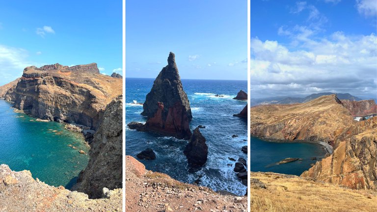
This strip of land is quite busy as it’s very popular and pretty much different from the rest of the island. It also offers refreshments at the trail’s end at Casa do Sardinha. We had some chilled Coke and tasty, homemade desserts, but it looked like they could prepare a proper lunch if needed.
From there, we wanted to go to Machico, where you can find another fake-sand (as I call them) beach. That means the sand is white as it’s also imported from Sahara. But unfortunately, the weather worsened again, and it was a little too cold to swim, so we decided to continue to Funchal, return our car earlier, and take a walk on the promenade. But it would’ve been a nice finishing touch to the hike.
And this is it!
Note: If you’re coming to Madeira to relax instead of discover, this itinerary would definitely be too much. We had ten days in total, so we spread these places into those ten days, but it can totally (and comfortably) be done in a week.
For more travel content like this, follow me on PeakD, Liketu & Instagram.

@tipu curate 7
Upvoted 👌 (Mana: 0/63) Liquid rewards.
Love the photos @itsmikyhere and you look lovely too.
I
My favorite part there was the 7th-day destination. I love hiking and heights, but I don't want to fall, lol. I can't hike here for the time being because of the season. I missed the trail..
!PIZZA
thanks for your comment! Hope you can hike it next time :)
Wao! What a beautiful landscape, I was impressed to see that you were practically among the clouds. Spectacular!
thank you!
Hory můžu každý den v jakékoli podobě :-)
!LUV
za použití #aroundtheworld
Beautiful view 🤩
Hiya, @choogirl here, just swinging by to let you know that this post made it into our Top 3 in Daily Travel Digest #1932.
Your post has been manually curated by the @pinmapple team. If you like what we're doing, please drop by to check out all the rest of today's great posts and consider supporting other authors like yourself and us so we can keep the project going!
Become part of our travel community:
You are really lucky and blessed to have the opportunity to visit awesome places such as these. Keep traveling and sharing ✨😁
yes, I am! Thank you for your comment :)
Congratulations, your post has been added to Pinmapple! 🎉🥳🍍
Did you know you have your own profile map?
And every post has their own map too!
Want to have your post on the map too?