It is said that “the Czechs have golden hands” and it is true here and there. What we have done well and what I am proud of is our mapy.cz for hiking, traveling by bike, cross-country skiing, using a car, or just finding a new place (viewpoint).
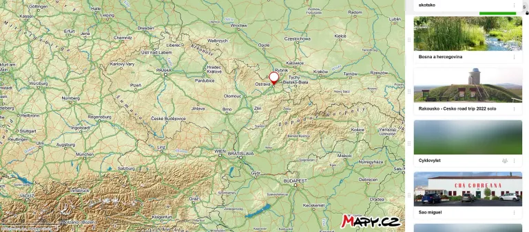
Until I traveled abroad, I thought everyone knew these maps, but unfortunately, I realized they couldn’t know them because they are promoted only on the Czech website:). In recent years, however, I have seen mapy.cz in various videos and travel tip videos
Therefore, I would like to introduce to you the unique and best app for hiking, cycling, skiing, cross-country skiing, sightseeing, and simply everything that every outdoor sportsman and nature enthusiast needs.
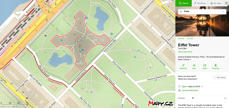
However, the app is not only for sportsmen and hikers, you can find restaurants and hotels that are linked to “booking.com” and you can book your accommodation directly. Also bobsleigh tracks, ponds, castles, beaches, hiking tips (or click on an area and it will pop up where you can go), and much more.
You will find a lot of gadgets that you usually have to search for separately. Here you only need to have mapy.cz. This app is available on all types of mobiles and computers and is fast and accurate.
The best thing — It’s completely free!
Simplicity, clarity, and colorfulness
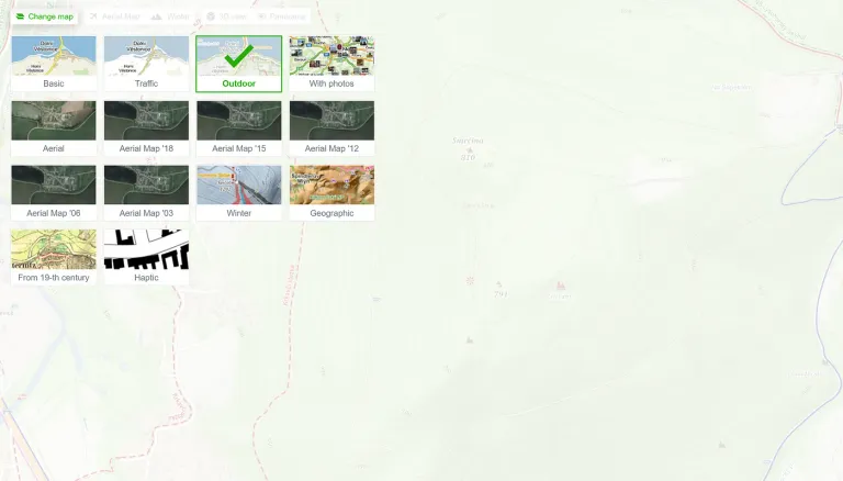
At the top left in the Change map box you can choose which mode you want, for me the most important are outdoor and winter and that’s what I will show you here. Then you will see individual contours, rivers, streams, peaks, places without trees, with trees, highways, and smaller roads. I haven’t encountered anything I missed in 15 years of use.
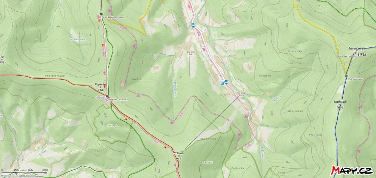
On the first map, you can see how the hiking trails are marked. All the routes are marked with the color that you find in nature. (In Czech we have yellow, red, blue, green,…). In most other countries it is mainly red. The dashed pink color with a cyclist indicates a suitable route for cyclists.
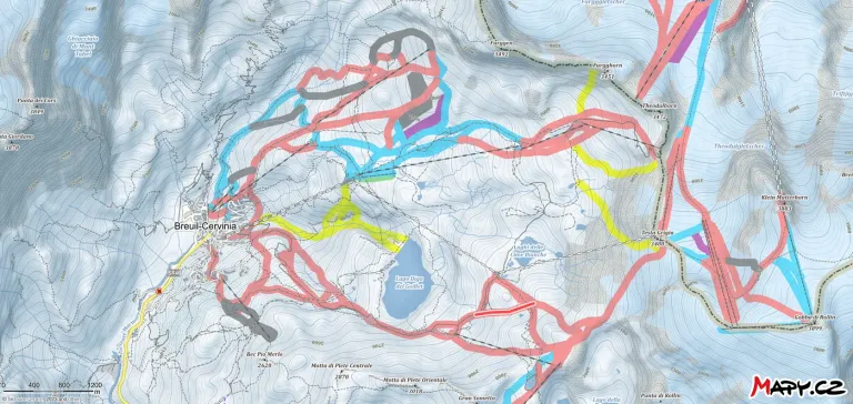
If you change the maps to winter maps (top left) you will see the cross-country skiing trails (careful here, it does not mean that it is traversed by snowmobile). In this mode, you will also see the slopes. So if you are in a resort and you go freeriding you can see how far you are from the slopes.
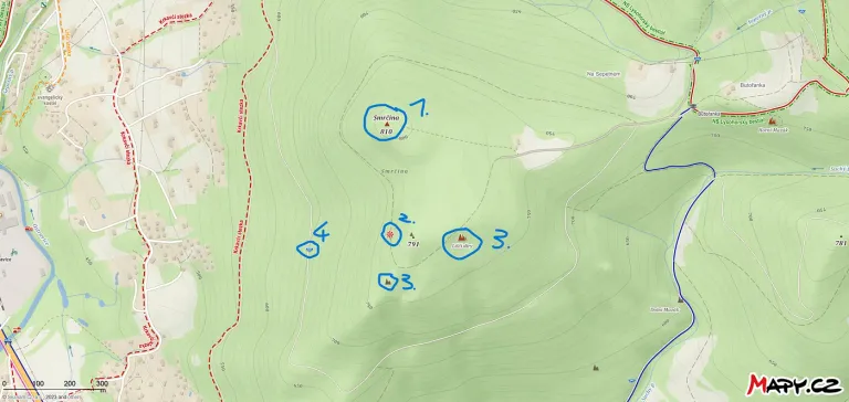
In the Outdoors mode (top left), you get a lot of simple symbols that you’ll recognize immediately. For me, the most important ones for the sake of photography:
1)Top of the mountain
2)This symbol means that there is a view of the valley or the surrounding mountains
3)Rocks (which mean almost the same thing to me as viewpoint)
4)Means a place where the water is running and you can get some to your bottle (it doesn’t mean drinking water!) - Don't count on it!
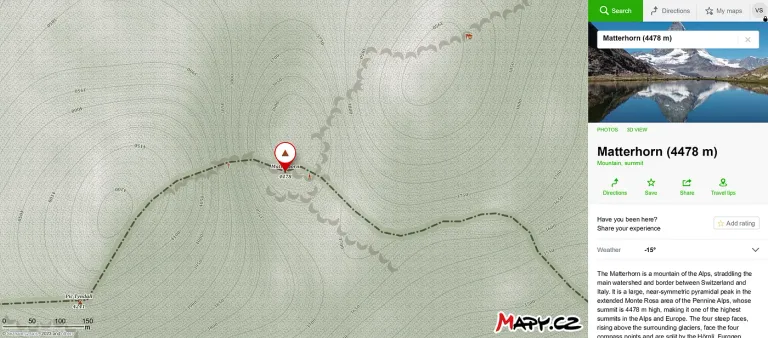
If you click on a peak or a landmark (and if they are known), you will get short information, a photo of what the place looks like, and the weather.
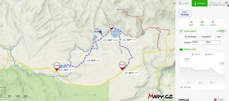
Setting your route is very simple. Just click on the points where you start and where you want to go and the app will automatically connect the places according to the way you choose (by foot, by car, by bus, by bike).
The system will then give you the length of the route, and the approximate duration of the journey. On the side, you will see the elevation and the current weather on the route (temperature, wind, and precipitation).
Very simple, and easy to understand and anyone can do it.
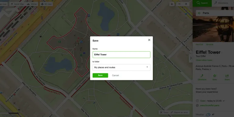
As a repository of places, routes, and tips for sunrises, sunsets
Click on the map point you want to save. To the right, click on the star called “save”. It will show you a box to which folder you want to save it or create a new one (I have it for example by country or movement activity).
Offline maps
Another great thing I use when I know I’ll be out of signal is the ability to download offline maps of your state then you don’t need data or wifi, just the GPS on your phone, and it works the same as with data. (You have to download it though!). I haven’t seen this tweak with any other apps.
Trip tips offered by the app = Where to find?
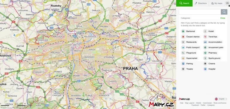
We find the place where we are going on vacation (for example) in Prague and we don’t zoom in on this city, but we leave it so that we can see the whole of Prague, then we click on “Search” and click on the Travel Tips icon.
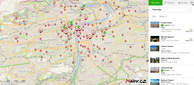
This will cause us to find many interesting places like waterfalls, gardens, castles, and many more, according to this app, and even with a rating of the place we want to visit.
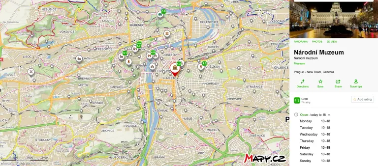
If you choose a particular monument, place, or observatory, you will often see information about that building on the right with the times they are open and some reviews.
You can enter your route right away and choose whether you want to walk, drive, cycle, or take public transport.
Of course, this doesn’t have to look only for “travel tips”, but also for gas stations, accommodation, restaurants, pharmacies, playgrounds, ATMs, theatres, information centers, cable cars, swimming pools, and anything:)
Searching for viewpoints
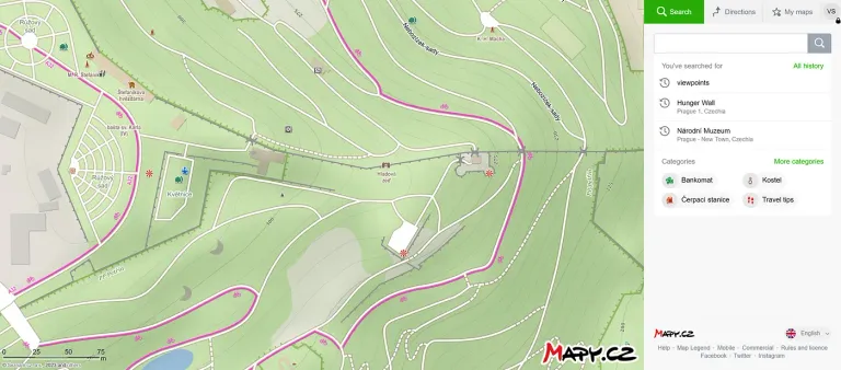
When looking for viewpoints, we need to have a more detailed idea of which part of the city we want to go to. But it works on the same principle. So we type “viewpoints” in the “Search” box and the app throws up a bunch of places where there’s some kind of view of the surrounding area.
If we click on a point, 60% of the time we can see what the view is like there.
Or just zoom in on the map and look for the red and white parachutes you see in the second picture.
Tip:
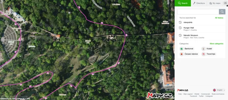
If the app doesn’t have a photo of the viewpoint, you can find out if you can see anything from the viewpoint by switching to Aerial maps and see if trees are blocking the view or not. I use it very often to find views in the mountains when I’m trying to find new viewpoints.
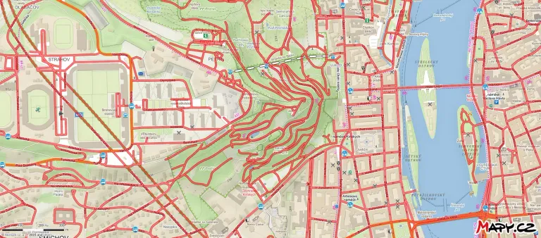
If you’re not so sure and you’re on a road, the app can now show you the place directly as it looks like by switching to Panorama mode (this puts all the roads you can see in red) and you just click anywhere on the map and you’ll see a “street view”. These maps include daily traffic on the roads and weather in a given location.
Personal experience
I’ve been using this app for over 15 years and have traveled and marched through countries like England, Sweden, Finland, Norway, the Czech Republic, Slovakia, Austria, Cyprus, Madeira, Poland, and more. My friends have used it in Asia, America, Switzerland, and more. But also in other less developing countries.
As far as tourism is concerned, I have only experienced one mistake so far, and that was in Finland when the trip went nowhere.
Plus, the app works great even on older phones and rarely crashes. It always showed me my location and thus I was able to get back on the trail I needed.
The only disadvantage of this app is that it does not yet cover all the languages of the world. However, you don’t need to know much English to use this app :)
This is to help you never get lost on the road as long as you keep your phone charged:)
Thank you for every interaction you make on my stories
Helping with translations: Deepl
Helping with grammar: Grammarly
Congratulations @vaclavs! You have completed the following achievement on the Hive blockchain And have been rewarded with New badge(s)
Your next target is to reach 3750 upvotes.
You can view your badges on your board and compare yourself to others in the Ranking
If you no longer want to receive notifications, reply to this comment with the word
STOPI use it too. There are mostly only official tourist routes on it. From the days when I used to go hiking, I know quite a lot of trails and local paths, which unfortunately are not there. Although, maybe that's a good thing. Some places should not even be known to the general public
Hmm, this is surprising for me. I visited many places and never happened to me, that I walked on a different route than showed me maps. Also, the forest paths are there..
So, if you're a well-behaved tourist, of course you stick to the marked trails. If you're an old-school hiker, you know all sorts of shortcuts and paths that tourists simply don't go on. But beware, even hikers don't go where they're not supposed to. As a result, you know many places that are beautiful or unique in some way, like location Q, where the only tree snake in the Czech Republic can be found. And it's a good thing that people just aren't there. In a short while, it would look like everywhere else. Nowadays, it's a bit of a problem everywhere, it's all private property, you're not allowed to do anything there, or it's a fenced-in game preserve. When we used to wander through the forests and mountains, there was nothing like that. The foresters mostly knew us and knew that we wouldn't make a mess of any clearing and tolerated us. Today, tramping is practically dead.
I agree with you, but I know quite a bit Beskydy Mountains, and I am using routes, like nobody else. And all the routes are in mapy.cz.. that's why I am quite suprised..
Jojo, Mapy a Seznam, na ty taky nedám dopustit. Možná je to tím, že jsem boomer. Uznávám, že google nabízí spoustu vychytávek, z nichž některé využívám (hlavně disk Google Drive), ale Mapy.cz my určitě vyhovují víc než ty gůglovské.
Chlapci @vaclavs a @rostik924, proč se mezi sebou nebavíte česky? 😮 😄
😂 Nevím.. já viděl angličtinu, tak jsem odepsal anglicky