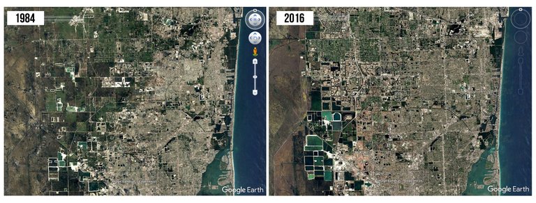
It's so Miami... If you ever have the chance to fly to Miami or just transfer there, look outside your tiny airplane window when flying over this Florida's gem. America's cleanest and richest city might be built on a swamp, with an overall elevation of around 1.5 m, the water is never far away with a astonishing views as a result. As you can see on the second picture, the city has been expanding enormously in the past decades. This expanding, however, happens on saturated and swampy soils. The first problem to tackle when designing a new neighborhood is the excessive water. As you can see on the satellite image of today, this is requiring some intensive urban planning and even island building. A small sidenote for those who are interested in urban segregation. These are the rich areas of Miami in the North and West, it is quite interesting to have a look on Google Earth to the urban areas south of downtown. No island building over there...


© Google Earth/Landsat/Copernicus
World of Photography Beta V1.0
>Learn more here<
Wednesday.
You have earned 5.05 XP for sharing your photo!
Daily photos: 1/2
Daily comments: 0/5
Multiplier: 1.01
Server time: 19:05:29
Total XP: 5.05/100.00
Total Photos: 1
Total comments: 0
Total contest wins: 0
Follow:
Join the Discord channel: click!
Play and win SBD:
Learn how to program Steem-Python applications:
Developed and sponsored by: Thank you for participating in #cityscapephotography, the weekly selection will be released on @photocontests@fairlotto@steempytutorials @juliank
@originalworks
You received a 60.0% upvote since you are a member of geopolis.
To read more about us and what we do, click here.
If you do not want us to upvote and comment on your posts concerning earth and earth sciences, please reply stop to this comment and we will no longer bother you with our love ❤️ https://steemit.com/geopolis/@geopolis/geopolis-the-community-for-global-sciences-update-2-higher-base-votes-new-logo