Through geology that's both a blessing and a curse...
It's a 2.5 hours drive to Suikerboshfontein eastwards from Johannesburg, but it is all mostly hidden from view underground in a relatively featureless Highveld plateau.
Grasslands and cultivated grasslands as far as the eye can see with the occasional herd of livestock... but then you see the cooling towers and smoke stacks of the numerous power stations, the fences, the signs and mountainous piles of earth and rock.
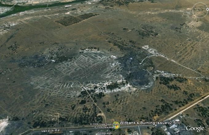
Then you know you are entering the Witbank coalfields.
The ancient Karroo rocks deposited at a time when Gondwanaland was still one single land mass and Southern Africa found itself near the center of this super-continent.
These coal seams of ancient plant matter from the swamps of the Gondwanaland interior are found lying just below the surface in this area and have provided South Africa and its neighbors with decades of cheap but dirty power.
The mining activities scar the landscape and new lacerations are opened up as a developing countries hunger for power increases.
Courtesy of Google Earth you can see the cellulite dimpled landscape of older collapsed underground workings and fresh new open cast mass removals exposing the power rich black coal beds below.
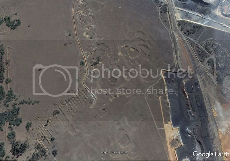
Spontaneously ignited underground fires that burn eternally have ensured that the massive tracts of land above the earlier workings of decades past remain useless.
Pockmarked and dimpled with subsidence and sinkholes these areas remain unsafe due to collapses that can occur at any time and with noxious fumes that belch from cracks and fissures as the only indicators of the eternally burning hell-fires that smolder beneath this portion of the earth.
But... the Karroo beds end and with them humankind's wanton destruction in an eternal quest to feed more power hungry gizmos and gadgets.
At Suikerboshfontein we find ourselves leaving the almost featureless Highveld and discover the beginning's of the escarpment that circles the high interior plateau of South Africa.
to be continued...
...and a SHOUT OUT goes to @elyaque for his cool badges... try some.

Great article so far and look forward to reading more on it a bit later, thanks and namaste :)
Great shots! Thanks for sharing this great informative post, Gavvet.
Upvoted & Followed.
Thanks
Wow ...very impressive images!
Google Earth... I highly recommend it... lots of intriguing things to explore... there is Mars and Moon too...
I used to work with Google Earth regularly, but never in that exploring mode. I don't even know it was possible to switch between Earth, Mars or Moon view!! But also noticed the version that is installed on my Pc is updated...Thanks for that :)
Interesting @gavvet. Nice little story about these coal fields.
Yea, I spent a couple of years in those power stations fueled with that coal a while back so this trip brought back memories.
Hi @gavvet
I am looking forward to the rest of your posts.
I hope they don't disappoint...
There is a certain rugged beauty of those landscapes despite the environmental disaster. The out of control underground fires is something I have come across before. Apparently there is a US town that had to be evacuated as a result of one - it's called Centralia you can read more about it on Wikipedia here. I first heard about it years ago on a great (now sadly discontinued) podcast called Hometown Tales.
Yup, mining often has disastrous unintended consequences.
Yes it is certainly a very risky business.
Thank you for your great post !