As we all know, Street View is a Google Maps feature that was released in 2007. This feature provides 360-degree views that make it easier for users to explore and navigate through beautiful images virtually on Google Maps. With technological sophistication as well, users can reach historical places or even climb mountains.
Of all the forms of progress, it seems strange that you only receive raw information without knowing what the history is. So, Street View uses several facilities that continue to grow every year to reach various kinds of sights namely cars, trikes, snowmobiles, trolleys and Trekkers. Here's the explanation!
Car

Google realizes that providing detailed visual maps is easier for everyone to understand about the geography of the world. Precisely in 2007 Street View first appeared in the United States using an SUV with a camera and a computer on the back.
Google Street View cars were launched in five cities in the US namely San Francisco, New York, Las Vegas, Miami and Denver. Its own function is to take pictures on public roads and places around the world. Users will feel at that place and are free to navigate as desired.
Trikes

Growing again, in 2009 Trike was introduced by Google with the idea that there are many places that cannot be reached by cars. The prototype was built in house and became a Trike Street View which is a three-wheeled pedi with a camera system above that allows the team to travel on narrow roads or lanes.
This includes small streets or alleys that are not reached by cars. So it is more detailed, users are more easily facilitated to see a deeper virtual view. Not only big roads, buildings, historic places, or mountains, but also small and narrow streets.
Snowmobile

Not stopping at the two points above, in February 2010, Google introduced the Street View Snowmobiles which were originally used to capture images on the slopes at the Olympic Games in Whistler. Since then, they have expanded to take all the pictures of all ski resorts around the world.
There are some updates in these snowmobiles because they have to survive the freezing snow and have an extra hard drive. Like the picture above, that was originally a snowmobile display that had been installed Street View.
Trolley
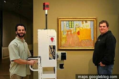
Next year, in 2011, in February, Google re-introduced the Street View Cart aimed at Google art projects. The tool will take 360-degree panoramic photos indoors from all museums around the world. If all three points above are outdoor views, then this time is in the room.
The Google Art Project was developed by a group of Google employees who like art, they collaborated with 17 of the most famous museums in the world. The Art Project offers an immersive experience for exploring museum information and high-resolution floor plans. Trolleys allow them to enter all parts of the museum with the results of advanced images. Not only museums, trolleys are also used in other places such as sports stadiums.
Trekker
In 2012, Google introduced the newest member of the Street View fleet, Trekker. This tool is the latest camera platform that uses the Street View camera system and adjusts everything into a backpack that is commonly used. There are 15 lenses on the top of the pole. Each one points in a different direction which allows it to create a 360-degree panoramic view.
Trekkers are used by operators who walk through sidewalks or walkways on foot and automatically collect images while walking. Trekker weighs about 40 lbs and is about 4 feet high and when used, the camera system extends 2 meters above the shoulder of the operator.
Trekker Technology entered Indonesia in 2014 and has tested some of the most famous places with amazing views of Raja Ampat, Prambanan Temple, Borobudur Temple and other places. The Trekker keeps updating the system as well as its use.
"The latest trekkers have a more stable system so taking pictures above and below the water can remain precise and enjoy balance." According to Nhazlisham Hamdan, Google Asia Pacific Program Manager.
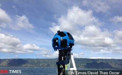
That was what some Street View history you have to know. And recently, Trekkers themselves have done mapping in the largest lake in Southeast Asia, namely Lake Toba.
Thank you
Greetings Steemit
COME TOGETHER ME WITH MORE HELPS ASSISTED TO IMAGINE


@farizsteem

Congratulations,
you just received a 18.51% upvote from @steemhq - Community Bot!
Wanna join and receive free upvotes yourself?

Vote for
steemhq.witnesson Steemit or directly on SteemConnect and join the Community Witness.This service was brought to you by SteemHQ.com