The good thing about meeting other people who also love mountain hiking is that I learned a lot of things from them. In this last trip I learned the importance of having a proper backpack for each hike, with all the equipment and extra clothes "just in case", as well as new ideas for lunches in remote areas (so I stopped eating only ham and cheese sandwiches, which was the only thing I could think of). But the most revealing thing for me was to have a map that works offline, something I had never taken into account before and that on several occasions helped us to get to places we had not taken into account at first 😃.
Lo bueno que tuvo el haberme relacionado con otras personas que también aman la caminata en la montaña es que aprendí muchas cosas de ellos. En este último viaje aprendí la importancia de tener una mochila adecuada para cada paseo, con todo el equipamiento y ropa extra "por si acaso", además de nuevas ideas para almuerzos en zonas remotas (así de paso dejo de comer solo sanguches de jamón y queso que era lo único que se me ocurría). Pero lo más revelador para mí fue contar con un mapa que funcione sin conexión, algo que nunca antes había tenido en cuenta y que en varias ocasiones nos sirvió para llegar a lugares que no habíamos tenido en cuenta en un primer momento 😃.
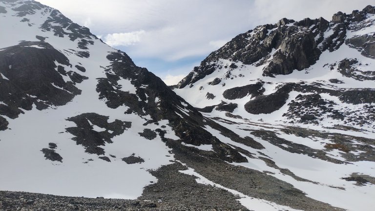
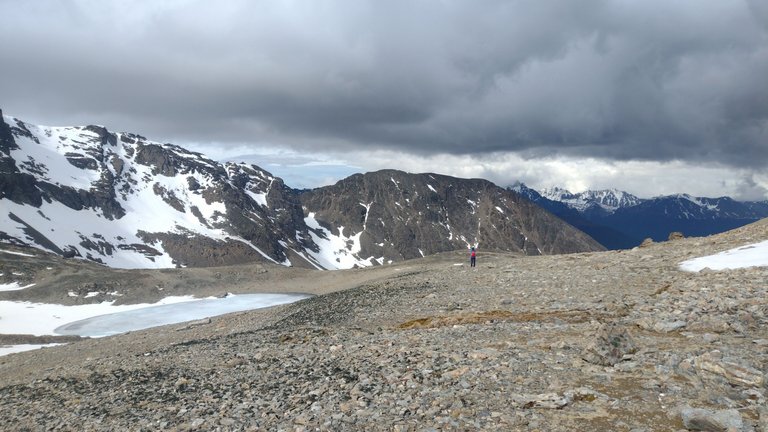
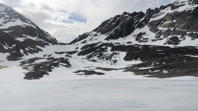
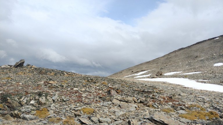
While working at the hostel in Ushuaia I had the opportunity to make several new friends to share hikes with. With some of them we got along very well, so much so that they waited for the end of my work shift to start their own walks with me. So it was when together we went to explore Cerro del Medio, a relatively easy hike that started very close to the hostel. This trek was quite interesting and, although we could not reach the summit because of the amount of snow, we still took the opportunity to walk a little on it 💕.
Mientras trabajaba en el hostel de Ushuaia tuve la oportunidad de hacerme varios amigos nuevos para compartir caminatas. Con algunos de ellos nos llevamos muy bien, tanto como para que esperaran a la finalización de mi turno de trabajo para empezar sus propios paseos conmigo. Así fue cuando juntos fuimos a explorar el Cerro del Medio, una caminata relativamente sencilla que partía muy cerca del hostel. Este trekking estuvo bastante interesante y, a pesar de que no pudimos llegar hasta la cumbre por la cantidad de nieve que había, igual aprovechamos para caminar un poco sobre ella 💕.
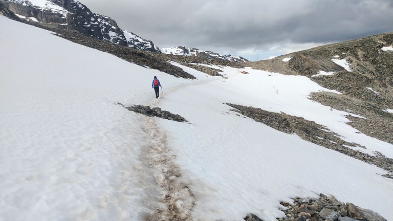
It was on that day that I heard one of the girls talking about Maps.me, a map that works offline. She was checking the road several times with this map and gave us information about how much time was left, how many kilometers and what slope we would have on that route. I found this map quite useful because even though these trails were well marked, there might be times when they were not. Also, once you get to a certain place you can continue to see what else is in the surrounding area because it is a specific map for hikers' trails 😃.
Fue ese día en el que yo oí a una de las chicas hablar sobre Maps.me, un mapa que funciona sin conexión. Ella varias veces fue chequeando el camino con este mapa y nos daba información sobre cuánto tiempo faltaba, cuántos kilómetros y qué desnivel tendríamos en ese trayecto. Este mapa me pareció bastante útil ya que a pesar de que estas sendas estaban bien señalizadas, podrían haber ocasiones en las que no. Además, una vez que llegas a un lugar determinado podés seguir viendo qué más hay en los alrededores porque es un mapa específico de senderos de caminantes 😃.
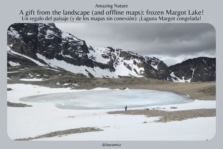
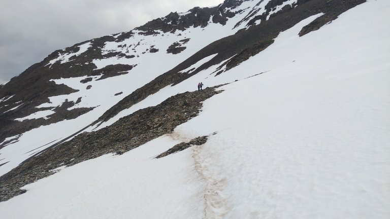
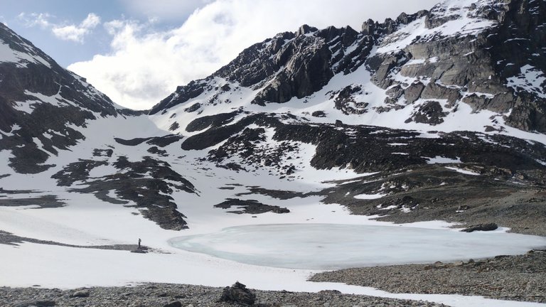
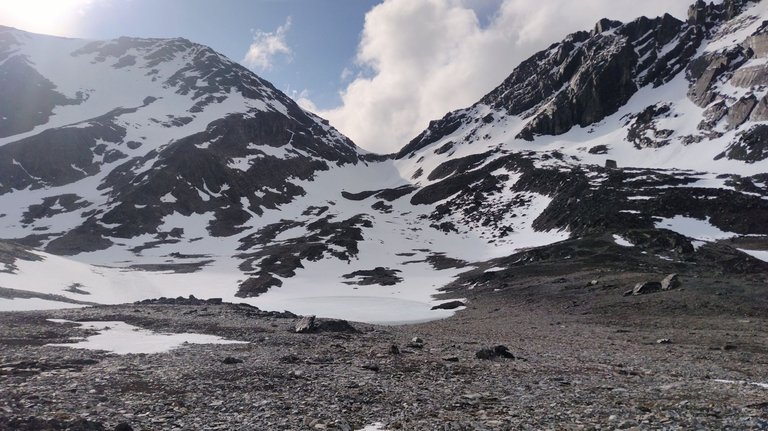
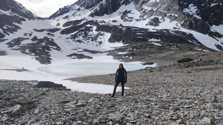
Once we had reached what we called "our summit", our trekking companion checked the map to see what else was in the area and found that only 500 meters away we had a lagoon, Laguna Margot. No one had mentioned any lagoon to us when we decided to go to Cerro del Medio, so it was a surprise to everyone. At that point there was also a little debate about whether to continue on an unknown trail or not, but seeing that the marks in the snow showed that people used to go to go, we decided to continue a little further 😃.
Una vez que habíamos llegado a lo que nosotros mismos denominamos como "nuestra cumbre", nuestra acompañante de trekking revisó el mapa para ver qué más había por esa zona y encontró que a solo 500 metros teníamos una laguna, la Laguna Margot. Nadie nos había mencionado ninguna laguna cuando decidimos ir al Cerro del Medio, así que fue una sorpresa para todos. En ese momento también hubo un pequeño debate sobre si seguir por un sendero desconocido o no, pero al ver que las marcas en la nieve mostraban que la gente solía ir para ir, decidimos continuar un poco más 😃.
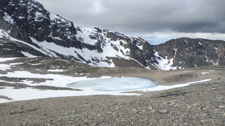
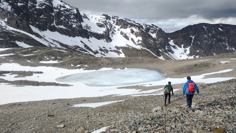
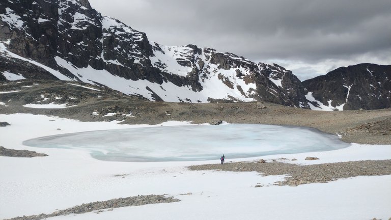
Luckily for us, the map did not let us down and we were finally able to reach the lagoon, which was frozen. We were very close to the beginning of summer, but in this high mountain area, it was still quite cold. Seeing the lagoon frozen was incredible because I had never seen anything like it before. As we approached, we noticed that it was already in the process of thawing, but it still had a good layer of ice on top. Of course none of us were crazy enough to walk on top of it, but we did get pretty close 😅.
Para nuestra suerte, el mapa no nos defraudó y finalmente pudimos llegar a la laguna, la cuál estaba congelada. Estábamos muy cerca del inicio del verano, pero en esta zona de alta montaña, el frío todavía era bastante. Ver la laguna congelada fue algo increíble porque nunca había visto algo así. Al acercarnos, notamos que ya estaba en proceso de descongelamiento, pero que aún tenía una buena capa de hielo encima. Por supuesto que ninguno fue tan loco como para caminar encima, pero sí que nos acercamos bastante 😅.
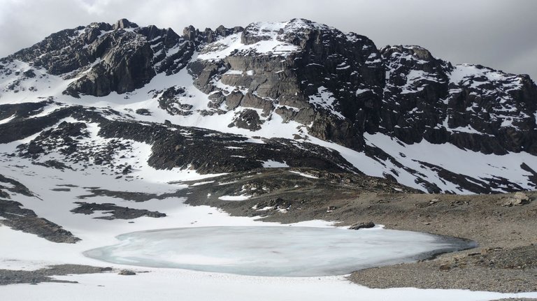
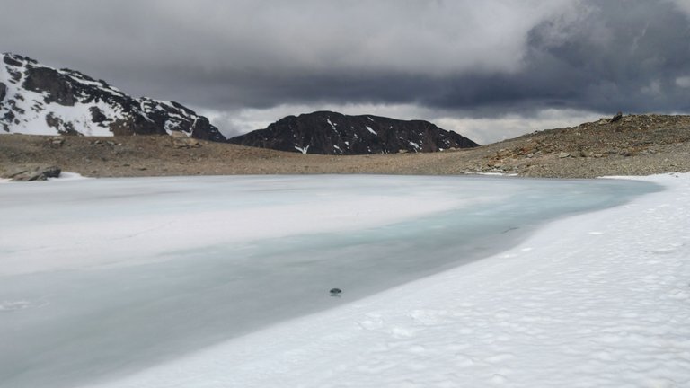
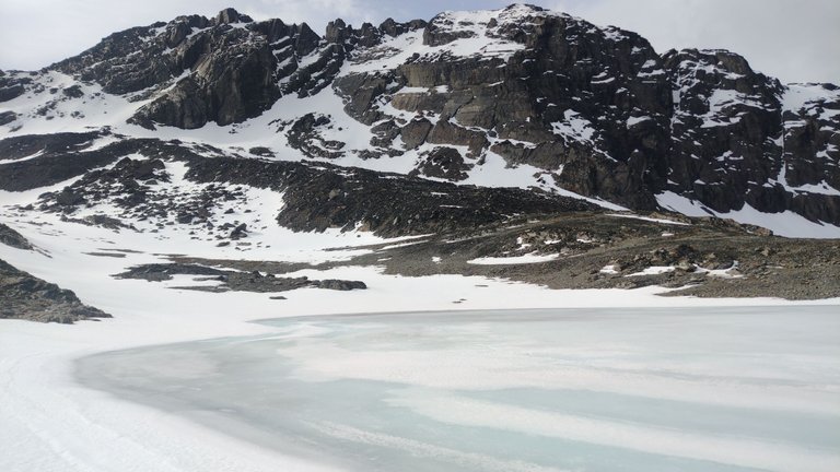
One cool thing about this lagoon was that depending on the angle at which you looked at it, its color looked different. At times it looked turquoise, but it also looked white until it blended in with the landscape. I really liked that we were encouraged to go there, the reward was great because it was something we did not expect to see so it was good to have that useful map 😃.
Algo genial de esta laguna era que dependiendo del ángulo en el que la mires, su color se apreciaba diferente. Por momentos se veía turquesa, pero también se veía blanca hasta camuflarse con el paisaje. Me gustó mucho que nos hayamos animado a ir hasta ahí, la recompensa fue muy grande porque era algo que no esperábamos ver así que fue bueno contar con ese mapa tan útil 😃.
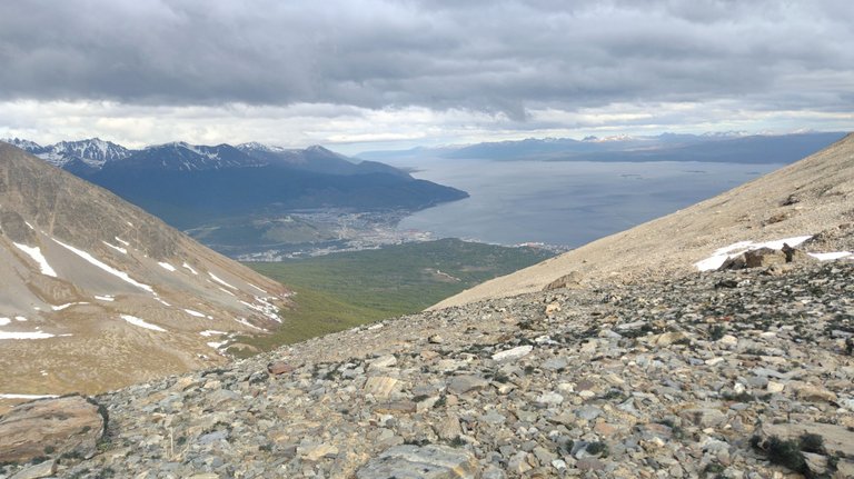
Although we had already had a good view of the city, from this part of the mountain we were also able to get closer to a point where we could see even more of the Beagle Channel. The city of Ushuaia is wonderful for its location and history, and worth seeing from all angles. It never disappoints with its beauty and incredible scenery ❣️.
A pesar de que ya habíamos tenido unas buenas vistas de la ciudad, desde esta parte de la montaña también pudimos acercanos a un punto desde donde se veía aún más el Canal del Beagle. La ciudad de Ushuaia es maravillosa por su ubicación y su historia, y vale la pena verla desde todos los ángulos. Nunca defrauda con su belleza y paisajes increíbles ❣️.
I also know that there are many other hiking apps like Wikiloc, but for the moment this one from Maps.me is working pretty well. However, I'm not one to go improvising in the mountains, I always inform myself well about the way before going to a place, but this was an exception since we were in a group and it was a place that looked easy to get to. Luckily, it did not disappoint us and we all left with some nice postcards of this place, which didn't stop surprising us until the last minute ❤️.
También sé que hay muchas otras aplicaciones de senderismo como Wikiloc, pero por el momento esta de Maps.me me viene funcionando bastante bien. Sin embargo, no soy de ir improvisando en la montaña, siempre me informo bien sobre el camino antes de ir a un lugar, pero esto fue una excepción ya que estábamos en grupo y era un lugar que se veía fácil de llegar. Por suerte, no nos defraudó y todos nos fuimos con unas buenas postales de este lugar, que no dejó de sorprendernos hasta el último minuto ❤️.
❤️ Hope you liked this post! Thanks for reading. ❤️
❤️¡Espero que les haya gustado este post! Gracias por leer. ❤️
Lau 💕.
📸 Portada creada en Canva. Todas las imágenes son de mi propiedad 💕.
Good morning dear friend @lauramica
The good thing about sharing passions with other people is the opportunity to learn different tips that are useful in travel, in this case, exploration and mountain hiking, how great that you found this map that works offline, and that guided you during the walk in this beautiful place, and the icing on the cake, discovering the proximity of this beautiful frozen lagoon
What beautiful landscapes you were able to photograph, seeing the small city above is really beautiful
Thank you very much for letting us know another little piece of this wonderful city.
Have a great day
Thank you very much Luis. If we had not had the map we would have missed this great place. Everything was very beautiful, the hike was worth it 💕.
Congratulations, your post has been added to Pinmapple! 🎉🥳🍍
Did you know you have your own profile map?
And every post has their own map too!
Want to have your post on the map too?
Glad that you found out about Maps.me—it was such great help in your amazing adventure. Anyway, thank you for sharing @lauramica !
Yes, absolutely. Thanks to you for stopping by 💕
Hiya, @livinguktaiwan here, just swinging by to let you know that this post made it into our Honorable Mentions in Travel Digest #2173.
Your post has been manually curated by the @pinmapple team. If you like what we're doing, please drop by to check out all the rest of today's great posts and consider supporting other authors like yourself and us so we can keep the project going!
Become part of our travel community:
Thank you 💕!
Wahhh, the place where you hike looks good but kinda scary too because of those snow that is covering some part of the mountains. I'm imagining an avalanche (≧▽≦). And whoa, a map that works offline. That is really helpful for sure. Navigating a place like this would be so much better.
Luckily at that moment I didn't think about avalanches hahaha. For a lot of snow, but compared to the real winter, they said it was little. The scenery was beautiful anyway 💕.
We appreciate your work and your publication has been hand selected by the geography curation team on behalf of the Amazing Nature Community. Keep up the good work!
Thanks for the support 💕.
This place looks so beautiful, I wish I was there 🥺
Me too rigt now 😂
Wao, it's a beautiful please. Congrats.
Thank you!
Cuando contaste lo de la laguna y vi las fotos dije ´´Ahhh una lagunita´´ jajaja nada que ver era muy grande, eso es algo que me sorprende del paisaje de montaña, si uno no tiene una referencia no se da cuenta de las dimensiones de las cosas. Por otro lado es excelente contar con un grupo para estas travesias más aun cuando aportan con el viaje como en este caso la aplicación del mapa.