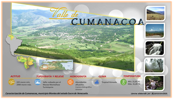
La tierra de Cumanacoa, se encuentra ubicada en un valle de 225 metros de altitud sobre el nivel del mar, bordeado por una serranía que llega a alcanzar los 2500 msnm, en el nor-oeste del estado Sucre de Venezuela. En su extremo sur se destaca geográficamente el Macizo montañoso Turimiquire, referencia a nivel mundial por poseer bosques nublados en una cordillera costera. Allí nacen muchos afluentes hídricos, por lo que convierte a la zona en una importante cuenca hidrográfica que provee de agua a muchas locaciones ubicadas en éste y otros estados vecinos.
El hecho de poseer un relieve plano bordeado por cerros y montañas ha permitido que posea un microclima tropical húmedo único en esta zona con una temperatura promedio de 22,73ºC; generalmente cada amanecer baña al valle de una sabrosa neblina fría que tiñe todo de blanco, sin embargo, al pasar las horas de la mañana se genera un calor tropical que contrasta con las horas anteriores hasta que el sol se pone y la noche regresa la baja y agradable temperatura. Se nota de manera muy marcada las únicas dos estaciones; la temporada lluviosa que dura aproximadamente 8 meses (de julio a febrero) y la temporada de sequía. La precipitación anual promedio es de 1572,90 mm, con una humedad relativa de 63,33% y de 7,5 horas luz por día.
Temperatura máxima de 31,85ºC y una mínima de 21,61ºC (aunque puede acercarse a los 10ºC en las zonas más altas del Turimiquire). Pueden notarse cambios bruscos de temperatura al comparar horas de la noche y del día por la misma condición geográfica.
Su vegetación natural varía de sabanas a bosques según la ubicación, pero se desarrollan diversos tipos de cultivos como el café, naranja, cambur y el más común la caña de azúcar, lo que representa su principal fuerza económica de la región, aprovechando sus ricos suelos orgánicos y el abundante recurso hídrico esparcido por todo el municipio.
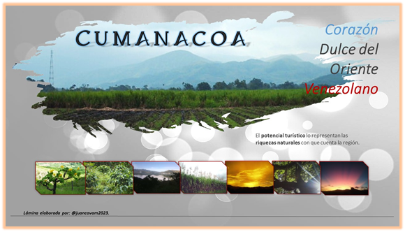
El potencial turístico lo representan las mismas riquezas naturales con que cuenta la región, sin embargo, aún no existen servicios para brindar la comodidad y la recreación a propios y turistas.
Continuaremos hablando de este hermoso rinconcito de Venezuela en mi próximo post.
Hasta la próxima.
• Algunos datos fueron tomados del informe de la Caracterización del municipio Montes del estado Sucre elaborado por el Instituto Nacional de Investigaciones Agrícolas INIA.
• Las imágenes fueron editadas por mi persona y las fotos son de mi autoría.

Hello again. Greetings from this humble servant, I hope you are very well.
As I commented in the previous article, I offered to publish some articles to tell you some interesting facts about my homeland: Cumanacoa. Here is the first one, with information on natural resources and some ideal environmental characteristics for tourists and other visitors to learn about the benefits that our beautiful landscapes offer.
The land of Cumanacoa is located in a valley 225 meters above sea level, bordered by a mountain range that reaches 2,500 meters above sea level, in the north-west of the Sucre state of Venezuela. At its southern end, the Turimiquire mountain massif stands out geographically, a world reference for having cloud forests in a coastal range. Many water tributaries are born there, which makes the area an important hydrographic basin that provides water to many locations located in this and other neighboring states.
The fact of having a flat relief bordered by hills and mountains has allowed it to have a unique humid tropical microclimate in this area with an average temperature of 22.73ºC; Generally each dawn bathes the valley in a tasty cold mist that dyes everything white, however, as the morning hours pass, a tropical heat is generated that contrasts with the previous hours until the sun sets and night returns to low and pleasant temperature. The only two seasons are very noticeable; the rainy season that lasts approximately 8 months (from July to February) and the dry season. The average annual precipitation is 1572.90 mm, with a relative humidity of 63.33% and 7.5 light hours per day.
Maximum temperature of 31.85ºC and a minimum of 21.61ºC (although it can approach 10ºC in the highest areas of Turimiquire). Sudden temperature changes can be noticed when comparing night and day hours for the same geographical condition.
Its natural vegetation varies from savannas to forests depending on the location, but various types of crops such as coffee, orange, banana and the most common sugar cane are developed, which represents its main economic strength in the region, taking advantage of its rich soils. organic products and the abundant water resources scattered throughout the municipality.
The tourist potential is represented by the same natural wealth that the region has, however, there are still no services to provide comfort and recreation to locals and tourists.
We will continue talking about this beautiful corner of Venezuela in my next post.
Until next time.
• Some data were taken from the report of the Characterization of the Montes municipality of the Sucre state prepared by the National Institute of Agricultural Research INIA.
• The images were edited by me and the photos are my own.

Gracias por traernos un pedacito de tu región. !Amo Cumanacoa, Gran abrazo!
Gracias a ti Gerónima. Comparto tu sentimiento. ¿Eres de acá?
Hi @juancovam2023,
Great to see you using the #travelfeed tag! We launched the #travelfeed curated tag more than 5 years ago and have been supporting the best travel blogs on Hive ever since. But did you know that TravelFeed has evolved? Based on the feedback of thousands of Hive travel bloggers we created TravelFeed.io.
TravelFeed.io brings together all the benefits of Hive decentralized blogging with features that you as a travel blogger will love: Photo galleries, Instagram embeds, custom maps and more. We also offer many of the features you love on Peakd such as drafts and post scheduling. And if you want, you can even use our easy site builder to set up your own travel blog on your own domain which can be a great way to generate a passive income from your blog!
Unfortunately, focussing on developing the best platform for travelers means that we no longer curate the #travelfeed tag. But, you can log in with your Hive account on TravelFeed.io to publish your next travel post, and it will be posted to Hive automatically! Every day, we select the best posts and reward them with an upvote and added visibility.
We would love to see you on TravelFeed.io soon :)