.jpeg)
Distance – 3 miles, each way.
Elevation – 5049′ in Newfound Gap / 1407′ elevation gain.
Route type – Out and back or section-hike.
Difficulty – Moderate.
Rating – 4.8 stars as rated on All Trails
STARTING YOUR HIKE.
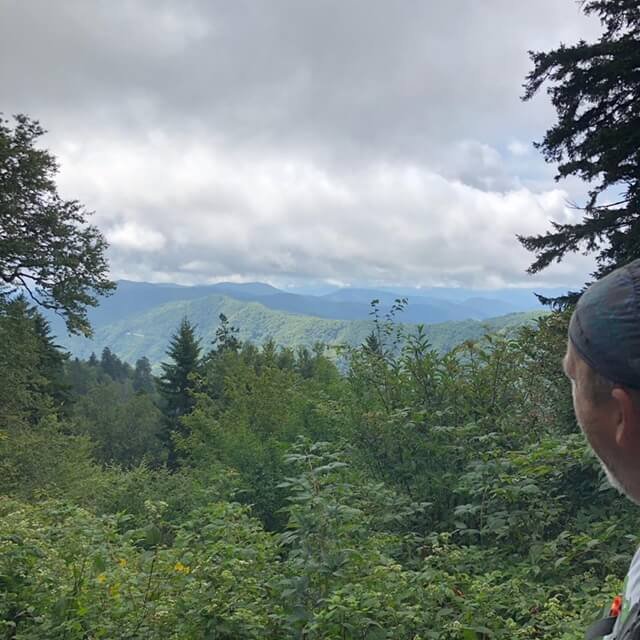
There is ample parking at Newfound Gap which is right on the North Carolina and Tennessee border. From the parking lot, there is a great view of the surrounding mountains and a chance to connect with some history at the Rockefeller Monument dedicated by Theodore Roosevelt in 1940. You’ll also be treated with the opportunity to use some modern bathroom amenities including running water and flushing toilets. Surely a treat for anyone through hiking on the Appalachian Trail.
WHAT SHOULD I TAKE?
- Good hiking boots or shoes are a must.
- Plenty of water. We recommend 3 bottles of water per person based on the altitude gain. More if it’s hot.
- You’re going to burn some calories so we recommend taking a few snacks.
- Bear spray. You can never be too careful.
OUR EXPERIENCE!
Even though it was the middle of August the weather was temperate with some cloud cover which made this a very comfortable hike. This portion of the Appalachian Trail starts right at the parking lot and immediately puts you into the surrounding forest. Almost from the start, the trail starts ascending along a rocky path and ascends over 1400 feet along the way. At one point we passed a couple hiking the other way who told us there was a black bear not far from the path about 100 yards back the way we were heading. Check out this video that Julia took. The sad thing is that I (Joe), had what I thought was a great video with a full shot of the bear about 10 yards from me which then ran right across the path about 5 yards behind me. Turns out I didn’t have the video rolling.
The best way to describe the views along this trail is “enchanting”. At several points along the hike, it literally felt like we were in an enchanted forest. Maybe it was how the light shone through the trees or maybe it was the endorphins flowing through our systems as we continued to climb higher along the trail.
THE SHELTER:
Upon arriving at the shelter there is a small path bearing south. This path leads to an area that has about half a dozen “bear hangs” so you can hang suspend your food or other valuable items out of the reach of bears and other wildlife. A short distance away is a primitive bathroom. We got to meet a couple of people here that were on longer section hikes. Depending on when you hike this trail you might get to meet some through-hikers as well. We decided to have lunch while we were here and just soak up the atmosphere.
THE RETURN TRIP:
The hike to Icewater Spring Shelter was mostly uphill so the return trip back to Newfound Gap was downhill and some of the areas on the path can be treacherous if you’re not careful. Once we arrived back at our car we checked our built-in phone app and it showed that we had hiked over 9 miles. We just couldn’t figure out how this was possible since it’s a 3-mile hike to the shelter and 3 miles back. Even taking into consideration some minor jaunts off-trail it shouldn’t have been that far off. We’re not complaining and we know it could have been an issue with the app itself. If you’ve hiked this trail and tracked the mileage we’d love to see your comments below.
FINAL THOUGHTS:
This has been one of our favorite hikes to date. The views were amazing. The hike was not too difficult but certainly not too easy. With dreams of one day hiking the entire Appalachian Trail we went into this hike with a sense of excitement and wonder and it did not disappoint. We give this trail a full 5-star rating and this is an experience that we will forever remember.
Before you set out on your next hike or adventure don’t forget to respect your surroundings. Always be prepared and share your experiences.
Some useful tools for the hiker in YOU!
AllTrails smartphone app – Best for smaller trails and side trails.
Guthook smartphone app – For the serious hiker. This app has extensive maps of some of the world’s largest trails.
Don’t forget to check us out on our YouTube channel at Trippin Brehenys. And remember, it won’t hurt you to subscribe.
There’s a whole wide world of wonders out there to explore and we would love to hear about yours!
Check out some more of our adventures at Trippin Travels.
Until next time, we’ll be seeing you… IN THE WOODS!
Sounds like a good hike. 9 miles is quite a bit, especially up and down hill. I find that down hill can be more challenging on the shins and knees. It would be nice to see some more pictures if you have any. Maybe in a future post :)
I'm terrible at taking pictures. My wife always does a much better job. Worst part was the video I thought I was taking of the bear. He was literally within 10 feet of me at one point.
Congratulations, your post has been added to Pinmapple! 🎉🥳🍍
Did you know you have your own profile map?
And every post has their own map too!
Want to have your post on the map too?
Congratulations @jbreheny! You received the biggest smile and some love from TravelFeed! Keep up the amazing blog. 😍
Thanks for using TravelFeed!
@smeralda (TravelFeed team)
PS: TravelFeed is in social media to reach more people, follow us on Facebook, Instagram, and Twitter.