The Rio Grande! "Grand River" in English. One of the best known rivers in America, due to both its historical significance, as well as its prominence in today's news.
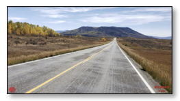
Lead Photo: Headwaters of the Rio Grande, viewed from the Weminuche Wilderness Vista
(Click on any image in this post, in PeakD, for anToday, we are going to be experiencing where this famous river "begins life." It may surprise a few people to learn the answer ...
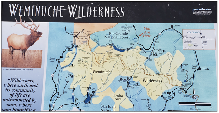
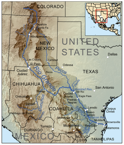
Before taking a closer look, this is a map of the area covered in this post:
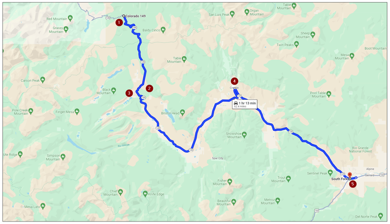
Source: Highlighted Google map of area covered in this post
Here is a brief look at each of the highlight points illustrated above, with links to more information, if you are interested in learning more about it:
- Slumgullion Pass - At an elevation of 11,530 ft (3,514 m), one of the highest I have ever driven over. Boasts of the steepest grade of any paved road in Colorado!
- North Clear Creek Falls Overlook - At an elevation of 10,013 feet (3,052 meters), this surprising waterfall is about 100 ft. high!
- Weminuche Wilderness Vista - A roadside vantage point, from which one can see up into the high country enclosed by the largest wilderness - 75% of the size of Rhode Island - area in Colorado. In which is found the headwaters of the Rio Grande.
- Town of Creede - At an elevation of 8,799 ft (2,682 m), site of a historic "silver (some gold ...) rush," beginning in 1889. Quite the history, with a peak population of + 10,000, before closing down operations in 1985. Today? The population is 257 (2020 U. S. Census)!
- Town of South Fork - At an elevation of 8,209 ft (2,502 m), site of the confluence of the South Fork and Rio Grande rivers. It is located on the far western edge of the San Luis Valley, through which the Rio Grande flows, before turning south into New Mexico.
Let's be on our way! 😎

Dropping down from the Continental Divide
Let's see ... How many times have I crossed the Divide on this trip? Well, I haven't been counting, but how about one more time with enthusiasm! 🙂
Slumgullion Pass
The Continental Divide divides North America - the East from the West. Whether water is ultimately flowing East to the Atlantic (trivia: never does it reach the Atlantic, unless you want to call the Gulf of Mexico the Atlantic ...) or West to the Pacific.
Here, though, this pass has a rare and very distinctive feeling of more North and South. Almost due north of here is where I turned mostly south, off of U. S. Highway 50, heading up into the San Juan Mountains, to Lake City.
Now, I am traveling more or less South, ultimately to spend the night in the little town of South Fork, way down at the western edge of the San Luis Valley.
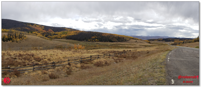
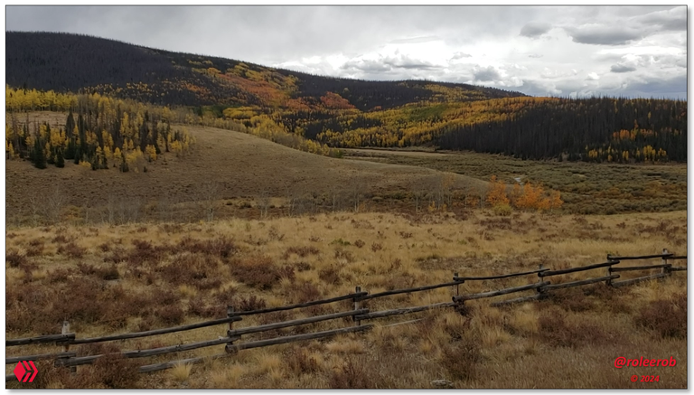
Loved the spectacular colors here, with its mix of evergreens and multi-color aspens
What a picture cannot capture is sound. The sound of flowing water (see it there in the lower picture?) combined with this wonderful combination of colors, was very nice. So soothing and peaceful ... With no traffic ... 👍
The only problem? The overcast skies. Which I can do nothing about ... 🤷♂️ So, on I go ...
Setting off, the "road less traveled" looked relatively flat, for the high country. Yeah, well, down around that curve in the distance, that changed very quickly, as I "fell down" off this high mountain pass ...
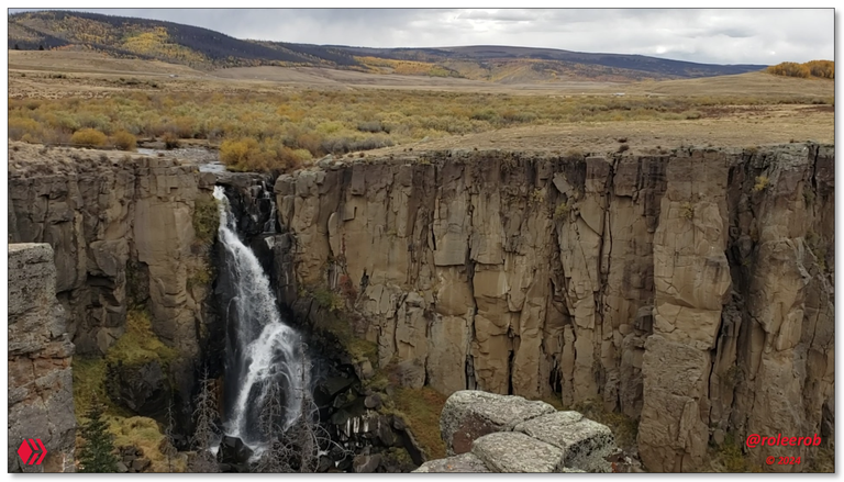
North Clear Creek Falls
So ... I was just driving along, minding my own business ... 😉 What? What did that sign say? A waterfall?
Resulting in a hard brake (that sign needs to be further back!) and turn in to see it. I absolutely love waterfalls!!
Sure glad I saw it and pulled in!
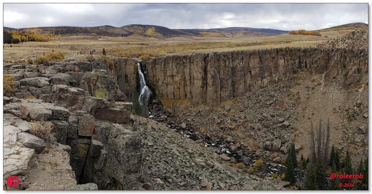
Panoramic view of this very nice surprise
View downstream, to the south ...
View across the canyon, to the east ...
View up closer, to the northeast ...
Photos: North Clear Creek Falls Overlook
I was here in the Fall, with the flow of water at "low ebb." What would it be like in the early summer months, at full flow?
It was wonderful to get out and stretch, breathe some clean, pure high mountain air, and enjoy this great little surprise along the way!
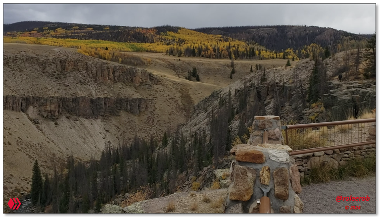
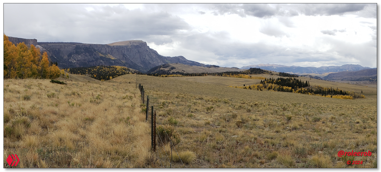
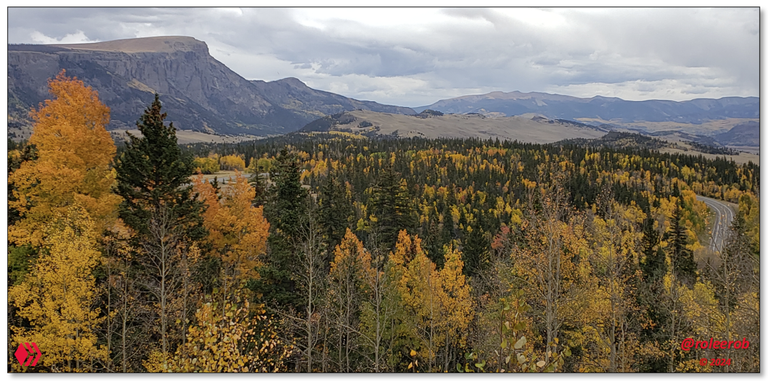
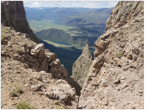
Wemuniche Wilderness Vista
Pulling off to experience this amazing view was the highlight of the day. The descriptive information signs brought vivid thoughts to mind of what it would be like to travel back up into the high country seen here only from a distance.
Way up in the Wemuniche Wilderness there, all the little mountain streams come together to form the Rio Grande!
Looking up past the Rio Grande Reservoir into the Wemuniche Wilderness

Vista Information Signs
My smartphone really was not up to the task of capturing this view to full advantage. Way off in the distance, we can at least see what clearly must be the Rio Grande Pyramid peak. Someday, I would love to come back here and see that peak and the surrounding mountains "up close and personal!"
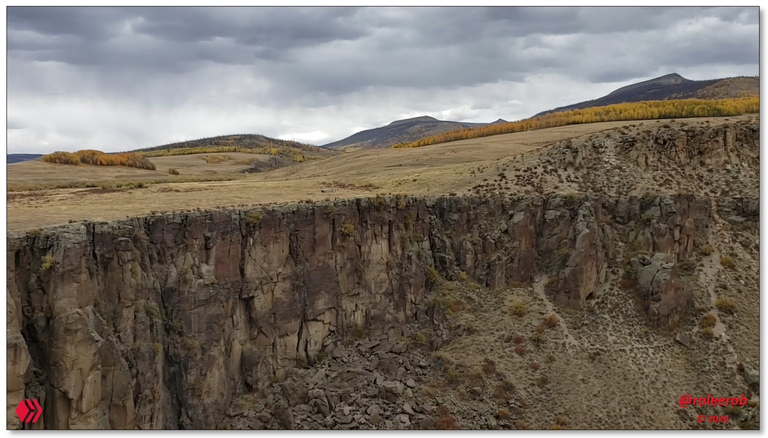
Bristol Head
In a state famous for mountains, this one was distinctive. Bristol Head is 12,712 ft (3,875 m) in elevation, so not that high. But ... It has sheer cliffs that set it apart, as well as how prominently it juts out into the space around it.
Bristol Head, from CO 149 heading down into the Rio Grande River valley below
From CO 149, below Bristol Head, looking South where the Rio Grande comes in, from the high country
Photos: Views of Bristol Head, from the CO 149
Wonder what the view is like, from a vantage point like the top of Bristol Head? Do you have a fear of heights? Wanna find out? Take the 4-WD drive to the summit of Bristol Head and you'll probably figure it out pretty quickly! 😉

Source 1: Bristol Head image on Google Maps.
Source 1: Bristol Head image on AllTrails.
As is so often the case, these views from atop a "peninsula in the sky" had me thinking about whether I would ever be back here, on a better day with more time, so I could drive my little road warrior up there and experience all of that wonderfulness firsthand! 🤷♂️
Rio Grande - Journey to the Sea ...
Begins here ... In the great State of Colorado ...
Wait!
"I thought that was the river that provides the 1,248 (2,008 km) border between Texas and Mexico. Almost as long as the Pacific coastline of the United States, at 1,293 mi (2,079 km)!"
True.
"Oh yeah, that's right, it flows into Texas, from New Mexico!"
True. Flowing north to south, for 470 (760 km), across one of the biggest states (5th largest) in the country. But ... It does not start there.
Nope. The 4th longest river in America, flowing for 1,896 mi (3,051 km) to the sea, comes down from the San Juan Mountains (click on image, for more info), of southern Colorado, as we have just seen in the previous section!
Source: Wikipedia's webpage on the Rio Grande.
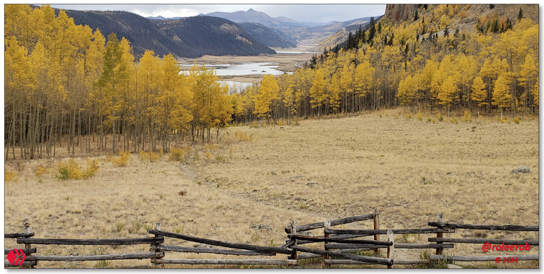
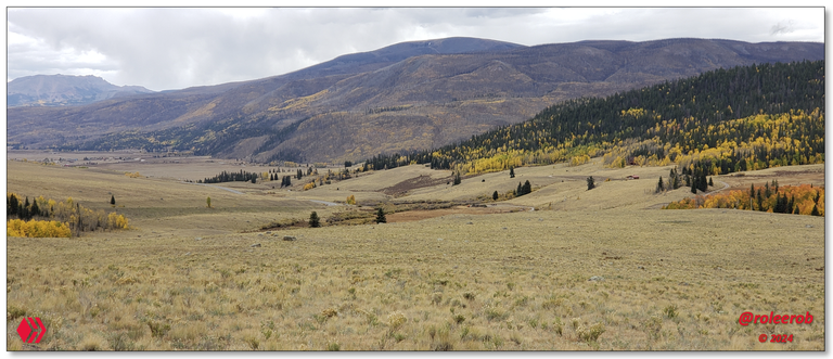
I will now treat you to some pictures of it, once it flows out of the high country (shown in the Weminuche Wilderness Vista section above) into a valley over 8,000 ft (+ 2,400 m) in elevation primarily focused on ranching:
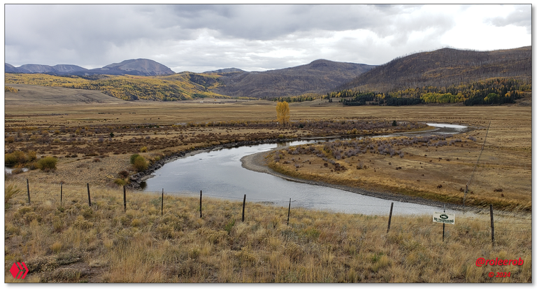

"And a river runs through it ..."
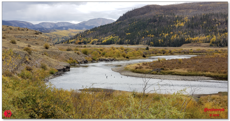
A flock of ducks and some happy cows on the upper reaches of the Rio Grande
Photos: Views of the upper reaches of the Rio Grande
From the wistful look, at a distance, up into the where the Rio Grande flows down out of the Weminuche Wilderness, past the remarkable Bristol Head looking down over the high mountain valley through which it flows, this day will be a fond memory for a long time.
While I didn't capture any interesting pictures of it, driving down along the upper reaches of the Rio Grande river valley takes you through the little town of Creede. It made a lasting impression on me, of the many little towns passed through on this trip.
Historically, it has a rich mining history of producing a remarkable amount of value, from the surrounding mountainsides:
"Over a period of 94 years, Creede’s total production topped 60 million troy ounces (more than 2,000 tons) of silver, 9,000 tons of lead, and 4,000 tons of zinc."
Today? At the end of its "15 minutes of fame?" The town population was 257 at the 2020 United States census.
Closing
Finishing my "excellent adventure" that evening, in the little town of South Fork, I knew it had come to an end. Why? Simple (to me). The surrounding conversation that evening at Ramon’s Mexican Restaurant , as it sits along the busy U. S. Highway 160, was of people heading over to popular destinations like Durango and beyond it, Mesa Verde.
No one was taking the RLT route north ... But ... The food was very good! 🫡
I hope you enjoyed "seeing through my eyes" this remote part of the American West. If so, I’d love to hear any feedback you may be inspired to provide.
Until "next time," all the best to you for a better tomorrow, as we all work together to build up our Hive Communities and add increasing value to our Hive blockchain! 👍 😊
Respectfully,
Blogger @roleerob
Hive "Dolphin" 🐬 & Man Cave "Dragon" 🐉
P.S. Unless otherwise noted, all images are pictures taken by my smartphone - a Samsung Galaxy S9+.
🌲 No trees were harmed in the publishing of this post! 🌲


Interested in reading more of my travel-related posts?
 |
RLT #1: Battle Pass Scenic Byway
The first of my RLT ("Road Less Traveled") series, as I began writing again on Hive in 2024. An open road. With no one on it. Out in remote portions of the great American West. Hmmm. I wonder what it all means? |
 |
Fond Memories: Return to Spirit West River Lodge
A remarkable place. Built by remarkable people. Writing about it resulted in some of my highest rewarded posts, including "Daily Top Payout" on Hive. Please don't miss my tribute to Lynn Finney, in the top comment.
|
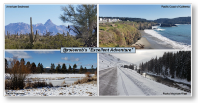 |
R2R Travelogue: Recap of "@roleerob's excellent adventure!" In winter ... My R2R series - "Road to Recovery" trip of a lifetime. In 31 days, I drove 4,984 miles through a part of 8 states - Colorado, Arizona, California, Oregon, Washington, Idaho, Montana, and Wyoming. Unforgettable memories relived and new ones made! |
Map of roleerob's
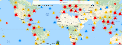
Check out HaveYouBeenHere's:
App •
Map •
Hive Travel Community
• Discord


This is a beautiful place to visit, I have also enjoyed all your photos. I love the way you write your posts, btw 🔝🙂
Have a great day and weekend @roleerob thanks for sharing ✨
!discovery 45
!ALIVE
Glad you find it worthwhile @dimascastillo90. Thanks for stopping by and letting me know! 🫡
You're so welcome @roleerob :)
Wow, That was a rich post. bookmarked for too many reasons, especially learning to manage better posts of my mountaineering experiences.
Fabulous photos too ☀️
Interesting response @kam5iz. You must have an eye for detail, as I would imagine most don't realize what it takes to put a post like this together. If they read it at all ...
Thanks for stopping by and letting me know you found it worthwhile! 🫡
So beautiful photos!!!
Very nice to hear from a woman from Laos, @chanmaly! As far as I know, this is the first time that has happened to me.
I don't always have the time to look into the profile of those I hear from, but in this case, I am glad I did.
Have a good day on your side of our big, wide world! 🫡
Congratulations, your post has been added to Pinmapple! 🎉🥳🍍
Did you know you have your own profile map?
And every post has their own map too!
Want to have your post on the map too?
Wow. You're "back amongst the living!" Hahaha ... Great to see these notifications coming through again!!
Dear @roleerob !
Rio Grande is Spanish words, so why do Anglo-Saxon Americans like you use that name?
It's surprising that the Rio Grande River is the dividing line between the U.S. and Mexico!
I am amazed at how Americans manage such vast uninhabited lands!
I wonder if Americans would know even if foreigners like me secretly invaded and lived in places like that!😄
Perhaps Americans are indifferent because it is impossible for foreigners like me to survive in such an uninhabited wilderness!
I guessed that perhaps only a small number of Americans could live in such an uninhabited wilderness!
I wonder how Americans defend their borders with such uninhabited wilderness!
I thought only strong people could live in the American wilderness!
Thank you for good article!
PS: I hope you understand that I couldn't find better English expressions!😃
What a great and amazing place that is! Hoping to set foot there someday
This post was shared and voted inside the discord by the curators team of discovery-it
Join our Community and follow our Curation Trail
Discovery-it is also a Witness, vote for us here
Delegate to us for passive income. Check our 80% fee-back Program
https://reddit.com/r/blogs/comments/1b4ubg1/rlt_8_the_rio_grande_and_silver_thread_scenic/
The rewards earned on this comment will go directly to the people( @dimascastillo90 ) sharing the post on Reddit as long as they are registered with @poshtoken. Sign up at https://hiveposh.com.