🏔
(EN)
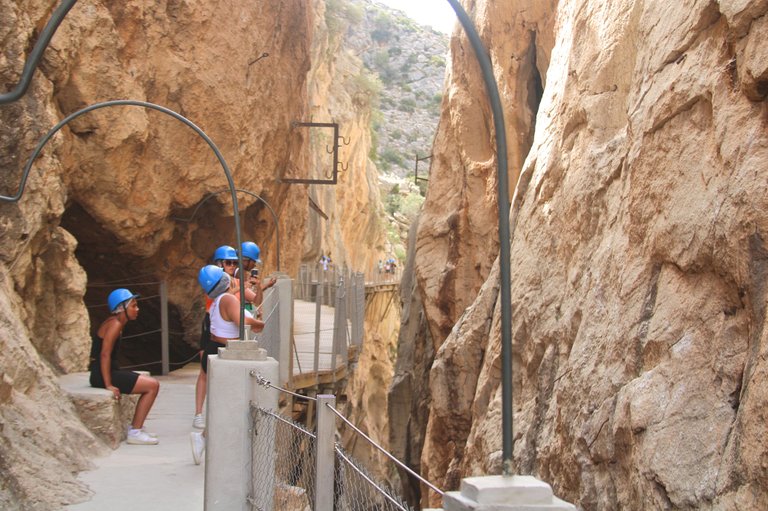
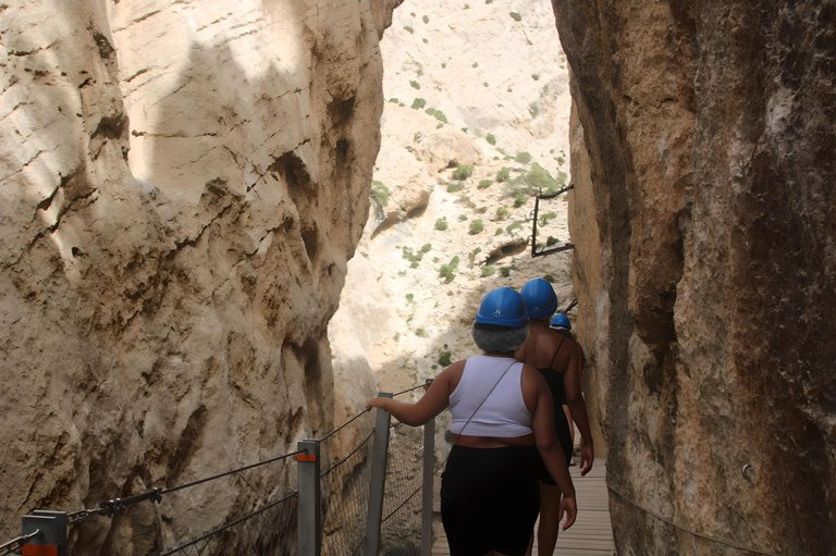
This route challenges the limits of human beings, and is considered by many to be the most dangerous, but I would like to emphasize again that after the works you feel safe, although there are still lifelines, a secondary entrance in case of fire and a helipad. It is necessary to wear a miner's helmet without being able to remove it.
The route is monitored by cameras and trail assistants where we can ask for help in any circumstances.
The view is simply spectacular over the undulating landscape.
(ES)
Esta ruta desafía los límites del ser humano, y es considerada por muchos como la más peligrosa, pero me gustaría recalcar nuevamente que después de las obras te sientes seguro, aunque todavía hay líneas de vida, una entrada secundaria en caso de incendio y un helipuerto Es necesario llevar casco de minero sin poder quitárselo.
La ruta está monitorizada por cámaras y asistentes de sendero donde podremos pedir ayuda ante cualquier circunstancia.
La vista es simplemente espectacular sobre el paisaje ondulado.
(EN)
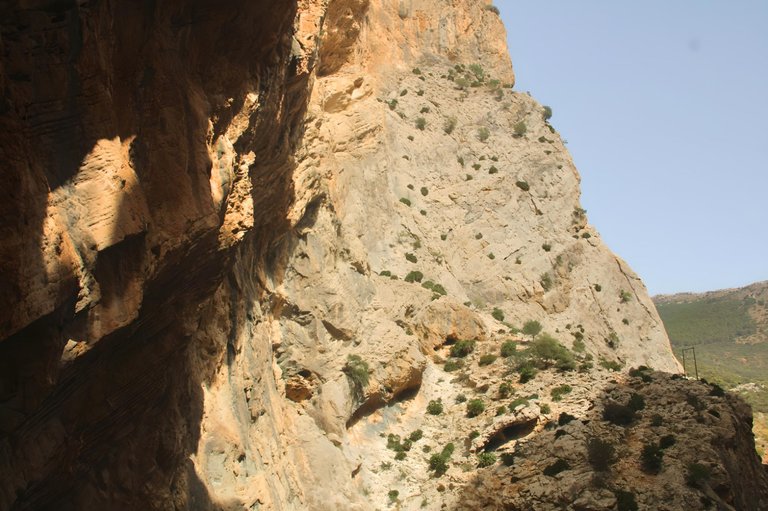
It is important to note that the temperature that day was close to 40 degrees Celsius, a very different temperature from where I live.
It ends up being a little unbearable because in addition to being hot, it is a very dry climate, as I couldn't miss it, I had to apply sunscreen along with my traveling friends.
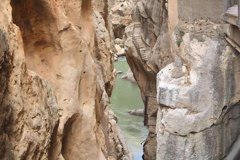
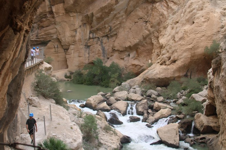
The route begins 100 meters above the river, skirting the vertical and imposing walls of the gorge. It is not recommended for people who have vertigo problems, although I was a little scared and couldn't miss this adventure and see my friends having fun.
(ES)
Es importante señalar que la temperatura ese día era cercana a los 40 grados centígrados, una temperatura muy diferente a la de donde vivo.
Termina siendo un poco insoportable porque además de calor es un clima muy seco, como no me lo podía perder, tuve que ponerme protector solar junto con mis amigos de viaje.
El recorrido comienza a 100 metros de altura sobre el río, bordeando las verticales e imponentes paredes del desfiladero. No es recomendable para personas que tengan problemas de vértigo, aunque tengo un poco de miedo y no había manera de que me perdiera esta aventura y ver a mis amigos divirtiéndose.
(EN)
We did the trail without a guide but there is also the option of having a guide, something I regret not asking for.
However, I was next to someone who spoke English and who was talking about the history of the trail's construction.
It was originally built in 1901 by the hydroelectric plant with the aim of connecting two cities.
The tracks were designed for workers to perform maintenance and transport materials for decades.
It has gained the reputation of being the most dangerous in the world.
(ES)
Hicimos el sendero sin guía pero también existe la opción de tener guía, algo que lamento no haber pedido.
Sin embargo, estaba al lado de alguien que hablaba inglés y que me hablaba de la historia de la construcción del sendero.
Fue construido originalmente en 1901 por una central hidroeléctrica con el objetivo de conectar dos ciudades.
Las vías fueron diseñadas para que los trabajadores sujetaran y transportaran materiales durante décadas.
Se ha ganado la reputación de ser el más peligroso del mundo.
(EN)
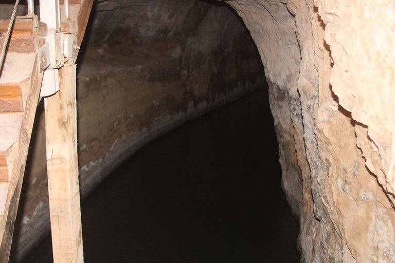
We walk about 1 kilometer up the slope until the road begins to gradually incline and we lose height. On the narrow path there are exits to a kind of everything inside the rocks with water that turns out to be the only emergency exit.
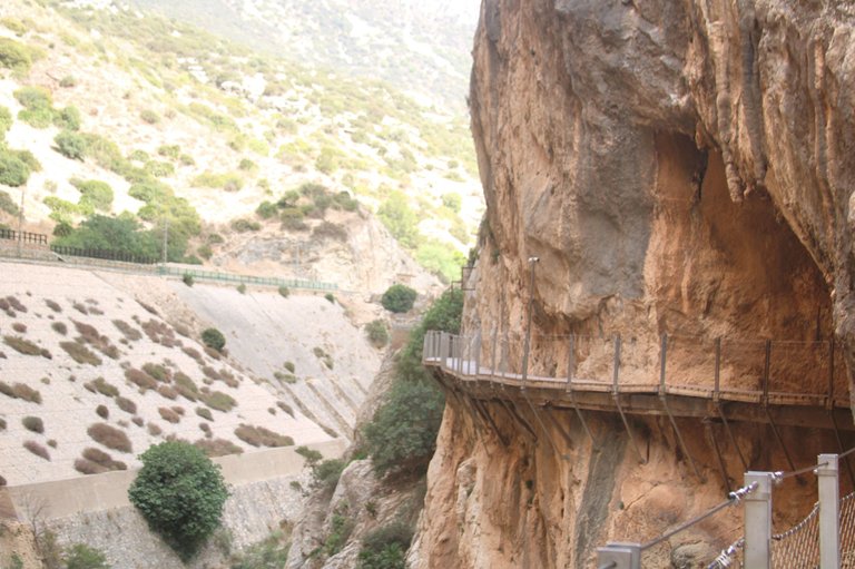
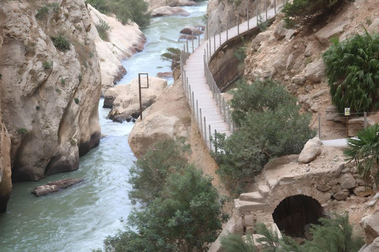
The path is very well signposted and has only one direction, which makes walking easier. With the works in 2015, the path became safer, with a wooden platform supported on central iron beams topped by a steel sideboard that prevents falls.
(ES)
Caminamos aproximadamente 1 kilómetro cuesta arriba hasta que el camino empieza a inclinarse progresivamente y perdemos altura. En el camino angosto hay salidas a una especie de todo dentro de las rocas con agua que resulta ser la única salida de emergencia.
El camino está muy bien señalizado y tiene un solo sentido, lo que facilita el paso. Con las obras de 2015, el camino se volvió más seguro, con una plataforma de madera apoyada sobre vigas centrales de hierro rematadas por un aparador de acero que evita caídas.
EN
The stairs begin to appear and each time we slide we go down further in relation to the river, it is still possible to see traces of the old walkways and small iron interventions through which the cables that carried electricity between the cities passed.
ES
Las escaleras comienzan a aparecer y cada vez que nos deslizamos descendemos más en relación al río, aún es posible ver vestigios de las antiguas pasarelas y pequeñas intervenciones de hierro por las que pasaban los cables que transportaban la electricidad entre las ciudades.
(EN)
As I couldn't miss it, I leave you with a record of the cavities that serve as an emergency route in the event of a fire or even a rock collapse.
where we can protect ourselves at any time in any part of the route because every 50 meters there is an entrance to it
(ES)
Como no podía faltar, os dejo un registro de las cavidades que sirven como vía de emergencia en caso de incendio o incluso derrumbe de roca.
donde podemos protegernos en cualquier momento en cualquier parte del recorrido porque cada 50 metros hay una entrada al mismo
(EN)
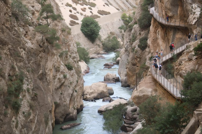
The roads always border the part of the gorge, thus becoming a path that winds through the mountain, as we can say.
It is shared a lot, as the photos look great with this beautiful background.
(ES)
Los caminos siempre bordean la parte del desfiladero, convirtiéndose así en un camino que serpentea por la montaña, como podemos decir.
Se comparte mucho, ya que las fotos quedan geniales con este hermoso fondo.
(EN)
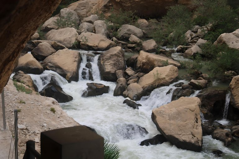
At this point we can almost touch the water where the current and noise make a pleasant sound, and when we look up we see the true immensity of the gorge with its imposing height.
(ES)
En este punto casi podemos tocar el agua donde la corriente y el ruido hacen un sonido agradable, y al mirar hacia arriba vemos la verdadera inmensidad del desfiladero con su imponente altura.
| CAMERA | Canon2000D | |
|---|---|---|
| LENS | 18/135 | |
| EDITOR | FOTOR |
Thank you very much for opening my content and reading.😀
Congratulations, your post has been added to Pinmapple! 🎉🥳🍍
Did you know you have your own profile map?
And every post has their own map too!
Want to have your post on the map too?
Congratulations @theycallmedre! You have completed the following achievement on the Hive blockchain And have been rewarded with New badge(s)
Your next target is to reach 70 posts.
You can view your badges on your board and compare yourself to others in the Ranking
If you no longer want to receive notifications, reply to this comment with the word
STOPTo support your work, I also upvoted your post!
Check out our last posts:
What an incredible place!
Hiya, @livinguktaiwan here, just swinging by to let you know that this post made it into our Honorable Mentions in Travel Digest #1991.
Your post has been manually curated by the @pinmapple team. If you like what we're doing, please drop by to check out all the rest of today's great posts and consider supporting other authors like yourself and us so we can keep the project going!
Become part of our travel community:
It is a fascinating journey reading through this post.
This is a great adventure and the view was indeed fantastic! 🤗 Thankyou for sharing a glimpse of this paradise 🤗