 The researchers have revealed how they have developed the innovative map which has discovered that three quarters of the world's industrial fishing vessels are not publicly tracked.
Just a few hours ago, an unprecedented map was made public, which was developed thanks to artificial intelligence and machine learning technologies. For the first time in history, it provides the ability to track the entire ocean.
In this way, using satellite imagery and artificial intelligence, researchers have mapped human activity in the sea more accurately than ever before. A great deal of previously unknown industrial activity has been discovered, including suspicious fishing operations, which may be illegal.
The maps were published in the journal Nature and are the result of research led by Global Fishing Watch, a non-profit organization backed by Google. One of the major discoveries is that "three-quarters of the world's industrial fishing vessels are not publicly tracked," and up to 30% of transport and energy vessels also escape public tracking.
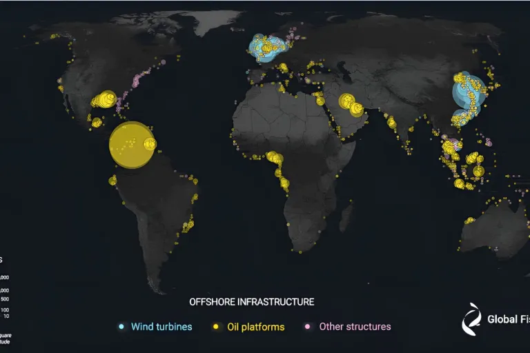
This map is unprecedented because, as explained in Nature, "more than 70% of the Earth's surface is covered by oceans, which provide food to billions of people and are used to transport goods around the planet. Offshore wind energy infrastructure, oil, and gas are also crucial for the global energy supply."
Based on this principle, the goal has been to "monitor human activity at sea," which has been a challenge "due to the inaccessibility and vast extent of the regions to be monitored." Satellite data can be used to map human presence in the oceans to an unprecedented degree, as the researchers state, revealing that a substantial amount of human activity is not publicly tracked.
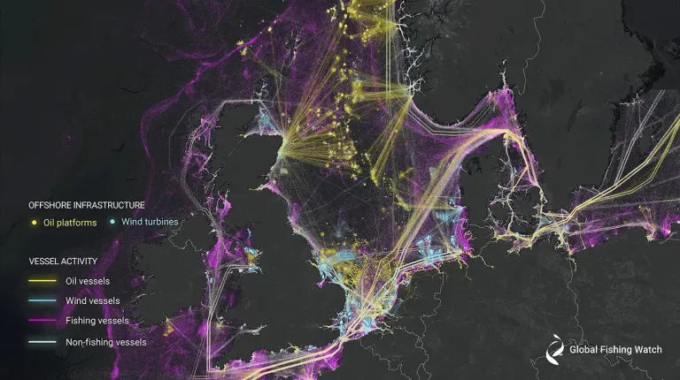
David Kroodsma, one of the authors of the Nature article and the Director of Research and Innovation at Global Fishing Watch, has stated that his organization, like others, has until now primarily relied on the maritime Automatic Identification System (AIS) to observe what happens at sea. While this system can be useful for uncovering illegal activities, it has significant limitations.
One of these limitations is that those engaged in illegal activities can switch off the device that sends signals when they want to avoid detection. Additionally, there are areas where the signal strength is irregular.
Analysis of 2,000 Terabytes In the new map, 2,000 terabytes of imagery from the Sentinel-1 satellite constellation of the European Space Agency were analyzed. Instead of taking traditional optical images, which is like taking photographs with a camera, Sentinel-1 uses advanced radar instruments to observe the Earth's surface. Radar can penetrate clouds and also "see" in the dark, and it was able to detect offshore activity that AIS overlooks.
Given that 2,000 terabytes is a huge amount of data to process, the researchers developed three deep learning models to classify each detected vessel, estimate its size, and classify different types of offshore infrastructure.
Another discovery is that "while fishing activity decreased at the beginning of the COVID-19 pandemic in 2020, dense vessel traffic was found in areas that 'previously showed little or no vessel activity' in public tracking systems, particularly in South and Southeast Asia, and off the northern and western coasts of Africa."
Source of potential text plagiarism
There is reasonable evidence that this article has been spun, rewritten, or reworded. Posting such content is considered plagiarism and/or fraud. Fraud is discouraged by the community.
Guide: Why and How People Abuse and Plagiarise
If you believe this comment is in error, please contact us in #appeals in Discord.