In my job at the European Space Agency, we look at what satellites can do for non-space sectors of society. Sometimes, however, you simply have to stop what you do and enjoy the majestic beauty of some of the images we get!
In this series, I share some of my favourite images I have come across in the last weeks together with a short explanation of what you are seeing in the image. I hope you will enjoy them!
WOLFE CREEK, AUSTRALIA
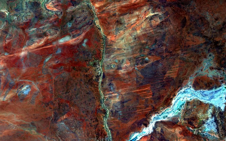
The Wolfe Creek in North-western Australia seen from the Copernicus Sentinel 2 satellite
image credit, ESA
This picture is a 10-metre resolution image of the Wolfe Creek Meteorite Crater National Park in Australia. In it, you can see both grasslands and also the beginning of the Great Sandy Desert, which is the second largest desert in Australia.
At the very centre of the image, you can see the Wolfe Creek Crater with a diameter of about 875 meters. Scientists believe that the crater was created some 300 000 years ago by a 50 000 tonne meteorite hitting the ground at about 15 meters per second, source. A fairly recent event compared to other large impact events throughout history.
The green and blue lines represent water bodies and rivers carving through the landscape. Roads can also be seen as straight lines across most of the image. In the lower central part, you see some bright, thick, horizontal lines, which are sand ridges shaped by east–west prevailing winds. Their brightness comes from a difference in vegetation or lack thereof.
BIG ISLAND, HAWAII
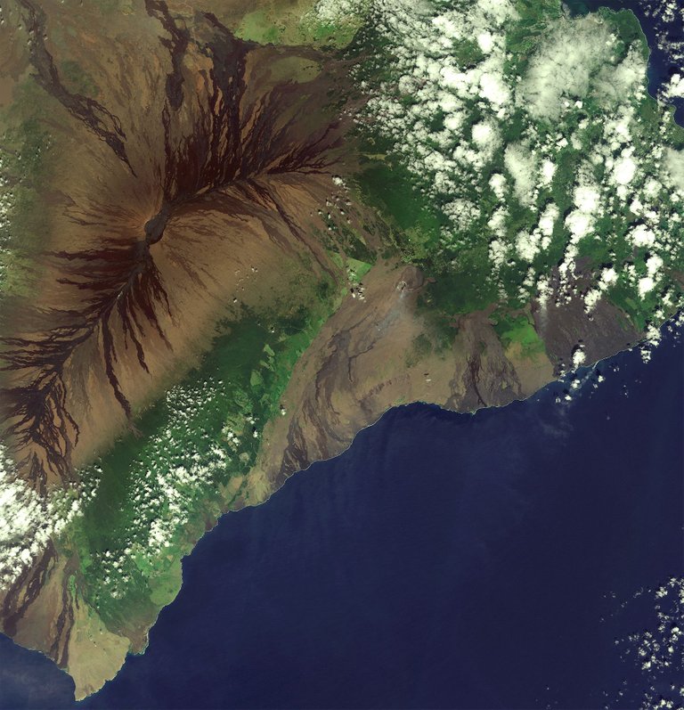
The Big Island of Hawaii seen from the Copernicus Sentinel 2 satellite
image credit, ESA
The Hawaii Big Island, seen in this 10-metre resolution image, is the largest Island of Hawaii. The Island is just over 10 000 square kilometres large and houses almost 200 000 inhabitants.
The Island is home to two great volcanoes, Mauna Loa and Mauna Kea, both towering more than 4000 meters above sea level. The one occupying the whole upper-left portion of this image is Mauna Loa. Although roughly 35 meters shorter than its neighbour in height, the Mauna Loa volcano is massive in terms of volume, historically considered the largest volcano on Earth. It is still active to this day. Indeed, the dark stripes you see running down the sides of the Mauna Loa are relatively fresh lava streams.
Near the centre of the image is a much smaller volcano named Kilauea at around 1250 meters tall. If you look closely you can see smoke emitting from its top. To its right, at the foot of the volcano centre right in the image, you can see the water steaming from lava that is flowing into the waters. The lava seeps out from a fissure in a lava-lake nearby, which just like a river floats down and out in the ocean.
The darker remnants of lava flow down its gentle slopes.Throughout the image, the brown and black lava flows – the darker being younger – are interspersed with green forests and fields. The clouds in this very high-rainfall area are formed by trade winds from the northeast being blocked by the mountains in the middle of the ocean, which also leads to frequent heavy rainfall.
CHINA’S TIAN SHAN MOUNTAINS
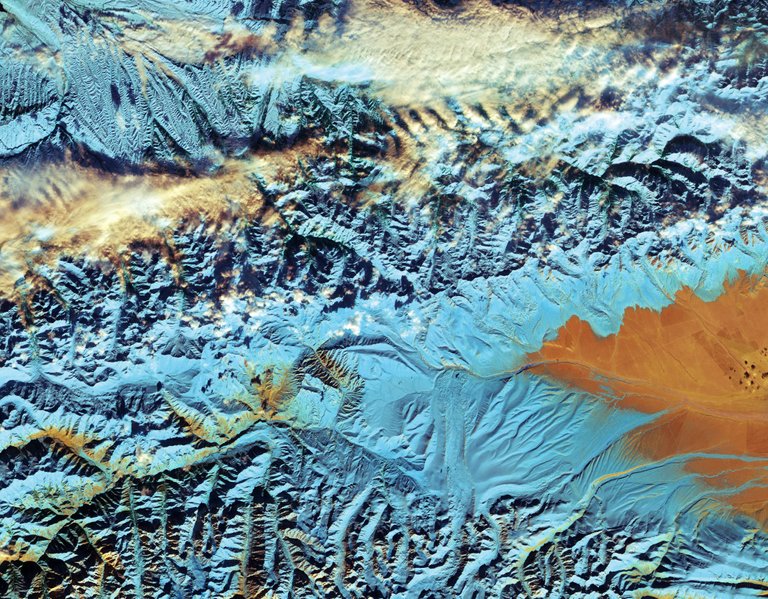
The Tian Shan Mountains in North-western China seen from the Copernicus Sentinel 2 satellite
image credit, ESA
This is another 10-metre resolution image, this time of the Tian Shan Mountains at the borders between China, Kazakhstan and Kyrgyzstan. This is a false-colour image, meaning it has been processed to give a different colour to light in certain portions of the electromagnetic spectrum. The difference, in this case, to a true-colour image is that the snow has been made light blue so as to separate it from clouds, which would otherwise look the same.
These mountains are one of the longest mountain ranges in central Asia and stretch no less than 2800 kilometres alongside the borders between the three countries. These glaciers have been closely monitored by scientists over the past decades. Measurements show that roughly ¼ of the ice-mass have already melted. At the current rate, scientists expect the glaciers to be gone by 2050. This is not only important to measure to keep track of the effects of climate change, local communities living downstream also rely on freshwater from these glaciers, adding to their importance.
The Bayanbulak Basin can be seen on the right side of the image as a great orange landscape. These large grasslands is the worlds highest breeding ground for swans at an altitude of between 2000 and 2500 meters above sea levels.
Bonus Image!
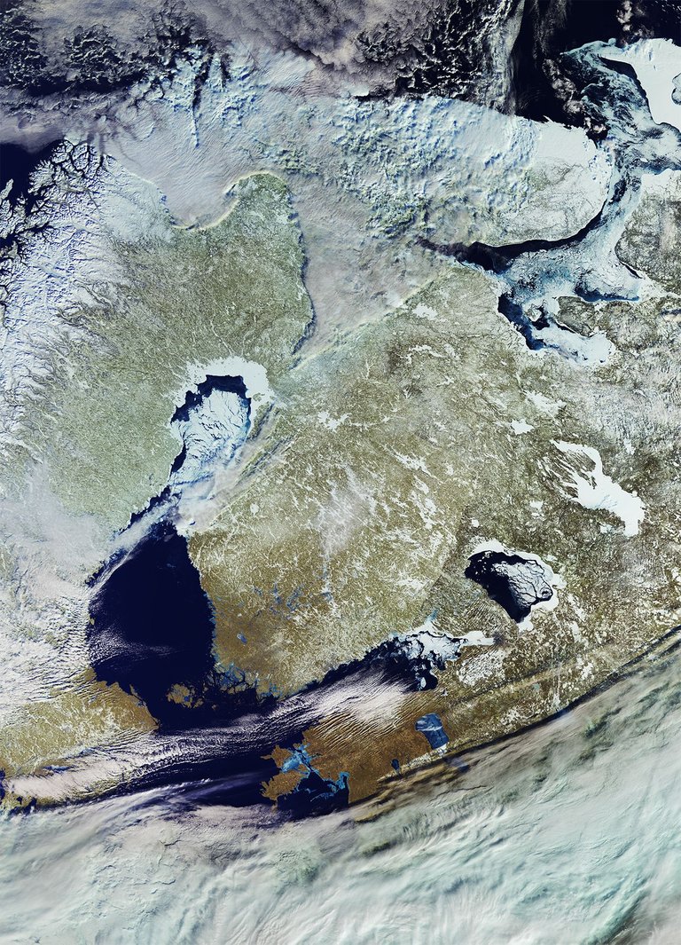
The Baltics, with Finland in the middle, seen from the Copernicus Sentinel 3 Satellite
image credit, ESA
In my last space-related post, 3 Amazing things we can now do with Satellites#3, I showed how Ice-breakers in the Baltic Sea relies on satellite data to know when and where to break open ice more efficiently during the winter.
This image is taken in March this year. As can be seen, some parts of the Baltic ocean, such as the northern-most part between Finland and Sweden, are still frozen. You can also see a large amount of sea ice on the east side blocking the entrance point to St. Petersburg in Russia. While it’s a beautiful image in and of itself, I found it fascinating to look also at many smaller corners of the image. From the snow-covered fjords in northern Norway to the sea ice north of Russia looking like white paint floating on top of the water.
Another interesting observation is the landscape inside Finland itself. Finland is often called the land of a thousand lakes, and the frozen lakes appear as white stripes and dots all over the country in a way that is quite distinguishable from Sweden.
Want to try processing new satellite images yourself?
All the main images above were taken by the European Sentinel satellites. The image processing has been done by ESA, the European Space Agency. You can download the raw data from their satellite constellation yourself for free here, which can be processed professionally by the free and open source tool snap. You can also browse new satellite images online for free using the EO Browser.
I hope to share more of these breath-taking images and continue making it a regular theme for my steemit blog. If there are parts of the world (perhaps where you live) you want to see an image of please let me know and I’ll dig it up!
Fredrik / @fredrikaa
Wow! Helt sykt flott bilder, nesten litt magiske! Takk for at du delte de med oss 😃
Takk for det:) Glad du likte dem! Ja jeg er helt enig, du skulle tro dette var en annen verden, eller at noen av dem var kunstverk. Prøver å ha dette som en fast ukentlig serie, så får jeg se hvor lenge jeg klarer å grave frem nye:)
Bare hyggelig!
Phew! Beautiful images, took quite a while to load but they were worth it. Didn't know about EObrowser, now I have a new toy to play. Since you asked, I am from Greece. Dig some photos from Olympus, the mountain of the gods XD
Yeah the image files are 3-13mb a piece ^^
The originals are around 1.5gb though when including all wavelengths :p
I'll see what I can do for the next post int he series ;)
1.5 gb? That's crazy!
I know ;p It's because of numerous data layers. There are 13 different sensors on the satellites recording wave-frequencies in different parts of the electromagnetic spectrum. These are then released in one large file from the same location at the same time. So that you can process different files together and produce images that help you see what is interesting to you. The program produces well over 5 Terabytes of image data daily. which will increase a lot more in years to come.
Amazing images. These images always give a feeling of adventure to me. Thanx for sharing and letting us know the beauty and vastness of our planet earth.
I'm glad that you like them!
Yup buddy you are sharing such rare pics that cannot be found here on steemit very easily. Nobody writes here about them.
As always, amazing selection! The fact that we live in such an amazing place helps :)
Thanks a lot @metabs, your kind support is always highly appreciated. Yes indeed it is the worlds natural beautify that makes this possible in the first place. I think nature will always be able to come up with structures and colour combinations exceeding our imagination, making it a wonderful source of art :)
Stunning images. This totally should be a regular theme for your blog. I enjoyed your short explanations a lot. Oh and that last image, too bad clouds covered my country, hehe. Keep going @fredrikaa!
Where are you from @m31? :) Maybe I can find one next time ;)
Very glad that you like them. Will keep this a theme for as long as I can come across regions and areas worth sharing.
Best photography award goes to satellites
I totally agree!
its all about skills
Very interesting . Upvoted and resteemed
amazing photography.......thanks nice post
Great post, thanks for sharing!
I enjoyed the post. Thanks
Stunning. Thanks for an original and great content on Steemit.
Wow! Nice images, the one from China is great