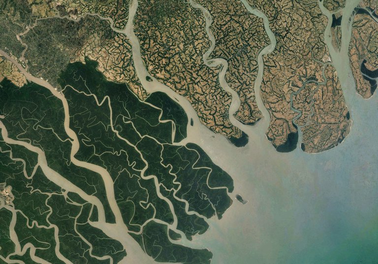
My favorite Google Earth Image of the day is one from the Ganges Delta in Bangladesh. It shows the enormous impact of environmental policies on land use and the complex consequences and trade-offs of environmental protection in a developing country. The left part of the picture is the Sundarbans National Park, an enormous mangrove dominated forest housing the extremely threatened Bengal tigers, flying foxes, etc. On the right, there is an extensive farming system, producing mainly jute, rice and tea. There is an immense population pressure and beside, over 65% of Bangladesh people work in agriculture. The available land is limited and is, as a consequence, cultivated intensively, leaving a deep and clear footprint on the landscape. Protected areas, such as the Sundarbans National Park may preserve natural ecosystems but it is worsening the problem of exorbitantly excavating ecosystems. There are two ways of looking at it... or you just look at it from the sky, astonishing!
(source of information: wikipedia))
Your post has been personally reviewed and was considered to be a well written high quality article!
You received a 60% upvote since you are a member of geopolis.
To read more about us and what we do, click here.
https://steemit.com/geopolis/@geopolis/geopolis-the-community-for-global-sciences-update-1
If you do not want us to upvote and comment on your posts concerning earth and earth sciences, please reply stop to this comment and we will no longer bother you with our love ❤️