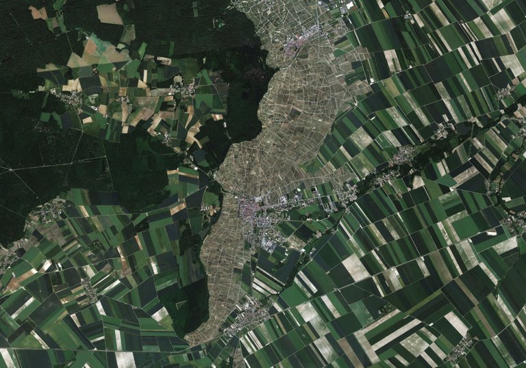
Welcome in the Champagne region in France. What you can see in the middle, are the grape ranks which are the first step to the famous champagne whine. The other fields are regular Western European cropland where farmers produce wheat and other cereals. The difference in income from the two types of agriculture is huge and it's pretty interesting to see why. If you want to buy an hectare of agricultural land in the Champagne region, you pay over a million dollars for the an hectare of land, located on steep slopes and with a rather infertile soil. If you want to buy a piece of land with fertile, well developed soils which a gentle slope and overall pretty easy to cultivate, you would pay around 10 000 dollars. Pretty counter-intuitive, no?
Long long time ago, farmers were already cultivating these lands. On the gentle slopes, with fertile soils, people were cultivating their most precious crops: cereals, legumes, ... You know, things they could easily eat or sell. On the hill sides, the soils didn't offer that much so the only crop that would grow a tiny bit, were grapes. However, there was a small problem: because of the relative cold temperatures in Northern France, the grapes weren't really sweet and rather sour. The whine wasn't really tasty, and in the good old times weren't bubbles a good thing. It resembled a bad fermentation until one day, some Northern French guy discovered that their sour whine tasted way better with this bubbles. A few centuries and a brilliant marketing campagne later, is it the crown jewel of the luxe products. The people from the Champagne region want to keep it this way and therefore, they limited the area where people could grow the grapes to produce real 'Champagne'. They decided that whine producers can only give their sparkling whine the name of Champagne when they only used grapes, grown on the fields where they once started to grow the typical sour grapes. You may remember that these fields are the rather marginal, second choice plots, on the steep hill sides. Nowadays, these hill sides are one of the most precious pieces of land, a whine producer could own but in fact, they are just special because they are everything but good fertile cropland...
One of my professors once told us this story on a field trip to Northern France and if you wonder: yes we did taste a lot of champagne that field trip!
You received a 60% upvote since you are a member of geopolis.
To read more about us and what we do, click here.
If you do not want us to upvote and comment on your posts concerning earth and earth sciences, please reply stop to this comment and we will no longer bother you with our love ❤️ https://steemit.com/geopolis/@geopolis/geopolis-the-community-for-global-sciences-update-1
Thanks for sharing! I was there a few years back. What I noticed was that a lot of the smaller vineyard owners were telling the same story. It was that a few big brands (I believe Moet Chandon was the main one) are buying up more and more small vineyards. As a result (since the amount of land for Champagne is capped), more and more small Vineyards are disappearing and with them their wines. Don't know how bad it really is, but I found it kind of sad to hear.
Yes, I heard similar stories! I also know that they want to expand these 'Champagne worthy fields' since they the demand is getting too big. However, this creates the problem of who will be the lucky groundowner who suddenly will see the price of his land going from 10 000 dollars per hectare to over a million. I am pretty sure his neighbors won't be too happy...
I bet that fact makes the land directly next to the current Champagne region already more pricey. It's sort of like countries claiming international waters near their land once they found oil under the seabed. :)
Yes, probably! I just think it is so interesting. It's a perfect example of how the physical setting of a landscape can start a chain reaction of events, policies etc. That's what I want to show with my series of google earth imagery, except from showing nice pictures of course!
Great idea, I'll keep an eye out for the next one!
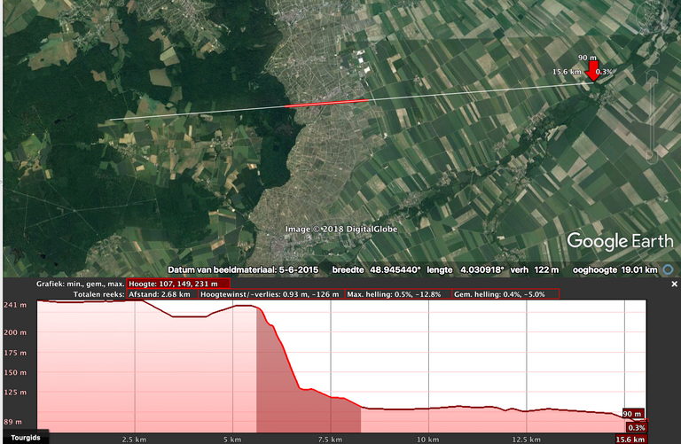
For those who don't believe the part about the steep slopes...
@ignacepelckmans, what tool dit you use for this picture?
Google Earth! This video pretty well explains how to do it.
Thanks!
@originalworks
Your Post Has Been Featured on @Resteemable!
Feature any Steemit post using resteemit.com!
How It Works:
1. Take Any Steemit URL
2. Erase
https://3. Type
reGet Featured Instantly – Featured Posts are voted every 2.4hrs
Join the Curation Team Here