Hello dear friends, I returned yesterday from a short trip of two days in the area of Jerusalem. My wife and I visited the stalactite cave, This is the biggest stalactite cave we have in the country. I know that there are many stalactite caves in the world, but in this stalactite cave, there are a very large number of different forms of stalactites, among the largest in the world.
The Cave location:
On the western slopes of the Judean hills, a few kilometers east of Bet Shemesh.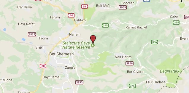
Stalactite Cave Nature Reserve
!steemitworldmap 31.755539 lat 35.024157 long d3scr
Image Credit - steemit world map
General Informatio
Location: The cave is located on the western slopes of the Judean mountains, on the southern face of Mount Yaela. It is south of the Soreq Stream, which gave the cave its other name, the Soreq Cave. The cave was declared a nature reserve on March 16, 1975. Area of the cave: 180 dunams Height above sea level of the cave entrance: 385 m.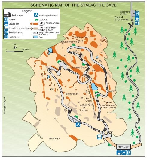
Schematic Map Of The Stalactite Cave
Image Credit
The discovery of the cave
The cave was discovered by chance in 1968, after a routine explosion in the nearby Hartuv quarry. The explosion created an opening on the hillside and revealed the cave. Subsequently, the area above it was declared a nature reserve, and work in the quarry was discontinued. Nature and Parks Authority prepared the cave for the public in a way that assures its preservation and prevents damage to the rare natural values in it. The cave was opened to the general public about a decade after it was discovered.
The slow creation of the stalactites and stalagmites in the cave continues to take place even now, although they are sensitive and vulnerable. Changes in temperature, humidity, and concentrations of carbon dioxide due to the exposure of the cave to the air and the entry of the public could interfere with the continued development of the cave and cause damage. In order to maintain the balance between the experience of a good-quality visit and the preservation of this unique natural resource, Nature and Parks Authority invests great efforts in managing the visits to the site, and in research and monitoring activities.
In 2012, Nature and Parks Authority installed a new lighting system that is both ecological and artistic. It consists of LED lights that do not emit heat, with wavelengths that prevent the development of algae.
The new lighting system not only preserves the cave but also emphasizes the beauty of the stalactites and stalagmites and creates a magical atmosphere that stimulates visitors' imagination by the shapes and images reflected from them.
How is a Stalactite Cave Created?
A stalactite cave is the result of the dissolution and sedimentation of rock. But can rock dissolve? It sounds amazing. But the stalactite cave is located in the midst of layers of dolomite rock. Rainwater that comes into contact with carbon dioxide (CO2) creates a weak acid capable of dissolving dolomite. Most of the CO2gets to the water through the soil in which it is found in large concentrations. This process takes thousands of years.Here is another way of looking at the dissolution process: CO2+ water carbonic acid Carbonic acid + limestone dissolved rock (by water). The rock dissolves along fissures through which water seeps. Slowly but surely, the water expands the fissures and creates caves. At this point, the process reverses itself: when a drop of water reaching the cave releases the CO2with which it is saturated, the limestone crystallizes, forming the stalactites, the stalagmites, and the other sedimentary forms in the cave.
In the former Yugoslavia Ð Slovenia of today, the processes of dissolution and sedimentation created the landscapes of an entire region. This region is called Karst and has given its name to all processes of dissolution and sedimentation of lime rocks on land.
Measurements of the Cav
The maximum length of the cave is 91 m (its average length is 80 m), its maximum width is 80 m (its average width is 60 m), and its maximum height is 15 m (about 5.5 m high on the average). The area of the cave is some 4800 square meters and its volume is 25,000 cubic meters. The air temperature in the cave is constant year-round at 22 ¼ C. Humidity ranges from 92% to 100%.Geology
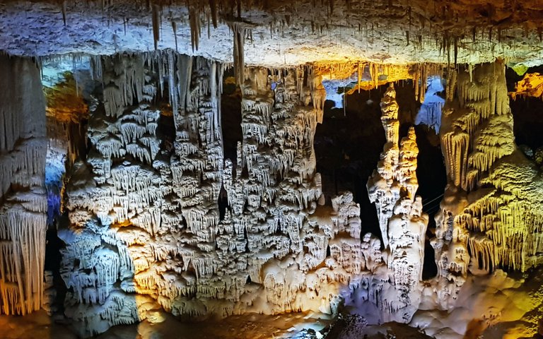
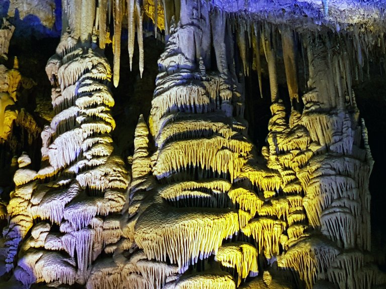
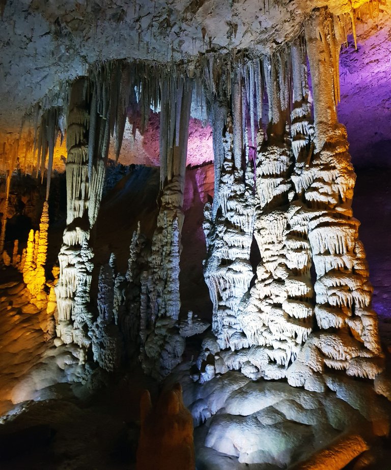
The Sorek cave was created due to dissolving and precipitating processes of dolomite and limestone rocks which created many stalactites and stalagmites in a variety of shapes, such as "macaroni" stalactites, columns, cave corals, curtains, "elephant ears" and a multitude of other shapes.The Creation of the Sorek Cave
Stalactite caves are created in limestone and dolomite rocks. First comes the process of dissolving the rock: rainwater percolating through the soil dissolves the highly-concentrated carbon dioxide in the soil, making it into a weak acid, called "carbonic acid", which is capable of dissolving the limestone and dolomite rocks in a very slow process that takes thousands of years. The acidic water percolates along cracks, widens them and creates cavities which grow and become caves. When the drop of water reaches the cave - the process of precipitation begins: the carbon dioxide that was in the water is discharged, and consequently the limestone material (calcium carbonate) that was dissolved in the water precipitates and builds the stalactites, the stalagmites and all the other precipitation forms in the cave. The dispersal of the stalactites and stalagmites in the cave is not random - their order follows the order of the cracks in the roof of the cave.
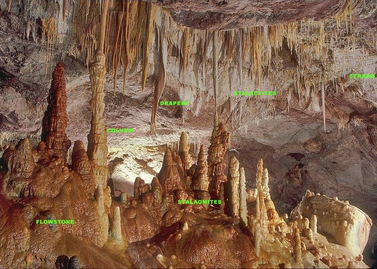
Image Credit
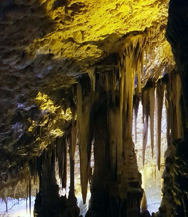
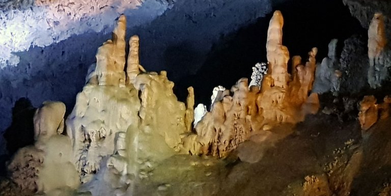
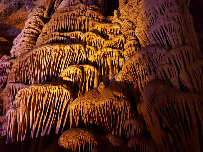
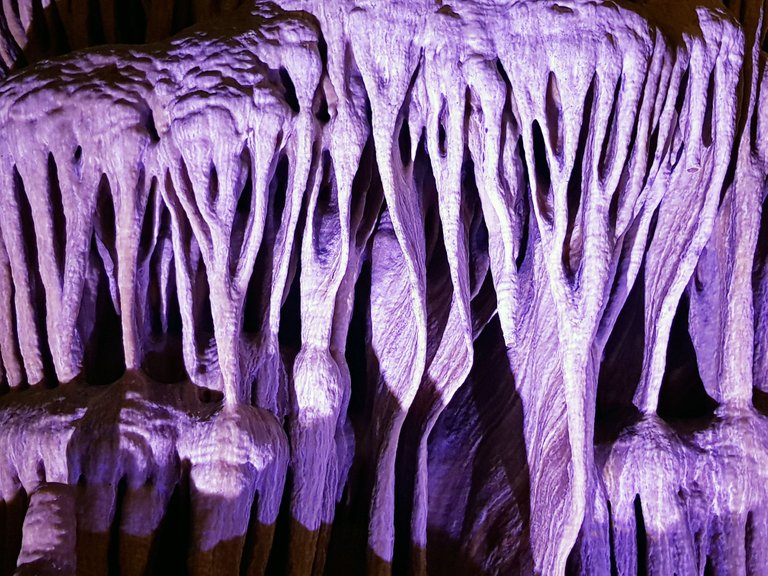
Stalactites -grow from the roof of the cave downwards. Around the drop of water that reaches the cave ceiling, the calcium carbonate forms a kind of ring, through which the next drop passes. Aring is added to the ring, creating a thin hollow tube through which flow the drops of water. These tubes grow very slowly, at an average rate of 0.2 mm. a year. When such a tube is blocked, the water starts flowing over the external surface of the stalactite, and its shape changes into a cylinder - thick at its base on the ceiling, and narrow at the point where the water drips. Sometimes the flow of water is not uniform, and the stalactites develop into asymmetrical shapes and create "curtains" and "elephant's ears".
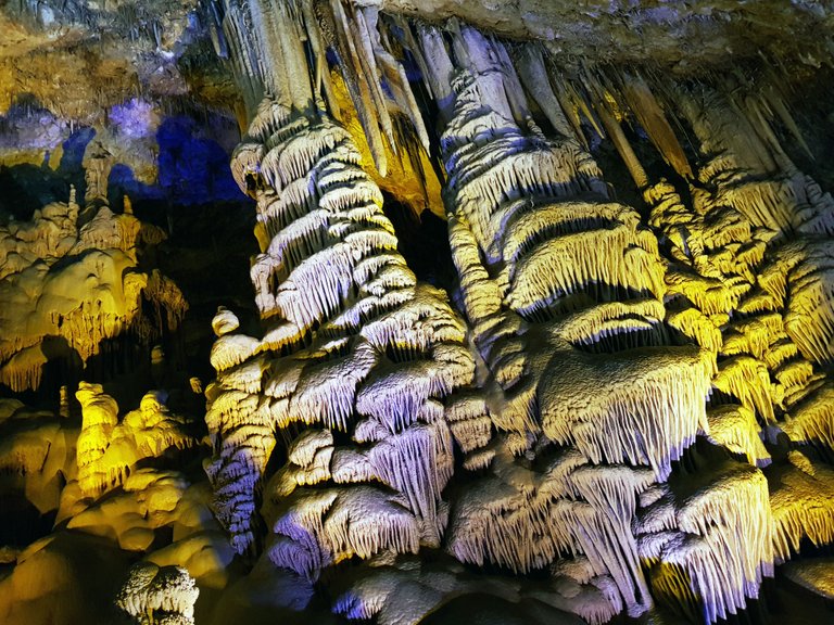
Stalagmites - the drops of water dripping from the roof of the cave and from the stalactites create the stalagmites - precipitation growing from the floor of the cave upwards. When the rate of drip is faster than the rate of precipitation, the drops fall, shatter on the floor, and only then does the material dissolved in them precipitate. This uneven precipitation creates stalagmites in various forms: "Mexican sombreros", "pagodas", and a plethora of other forms. The stalactite and the stalagmite underneath it could unite and create a column. These columns could also join each other, creating screens, thus dividing the cave into smaller areas. All these amazing shapes were formed over thousands of years, but many areas in the cave are still active, and the stalactites and stalagmites in them continue to grow. This is evidenced by the sound of water dripping and splashing on the floor of the cave. In order for the creative processes of the cave to continue, it is very important to maintain stable climatic conditions: 22-23 degrees C and 90-100 percent humidity.
The stalactite/stalagmite cave as a research tool - alongside the beauty of the cave, it serves as a window into what is occurring underground. By examining concentrations of tritium (a radioactive isotope of hydrogen), it is possible to learn the period of time it takes for rainwater to reach the cave from the surface. It was found that the migration of water into the Sorek cave is not uniform - from a few days to 35 years. The creation of stalactite caves is a very long process, and therefore the cave contains within it a great deal of important information on ancient climate and earthquakes. In the course of their creation, stalactites and stalagmites document the composition and quantity of rainwater, temperatures in the vicinity and the type of vegetation throughout the periods in which they were created. Thus it is possible to reconstruct climatic conditions that prevailed in our region in recent millennia. Other studies use the signs of collapse in the cave and broken stalactites and stalagmites to date ancient earthquakes.
A few more pictures I took
Source:
References Article Source: Stalactite Cave Nature Reserve
Pictures taken by me @nirgf Other sources of images are cited below the respective picture.
My friends, hope you enjoyed it. More posts from other trips Will be published later
Thank you, Hope to see you again on my next posts


Until next time, thank you for visiting @nirgf
Feel free to leave a comment below!
!originalworks
The @OriginalWorks bot has determined this post by @nirgf to be original material and upvoted(1.5%) it!
To call @OriginalWorks, simply reply to any post with @originalworks or !originalworks in your message!
That's wild, it found you, even though you accidentally used ! instead of @... Wow...
My name (Craig) basically means Cavedweller, so

I appreciate caverns!
Thanks caveman :)
LOL!
Congratulations, Your Post Has Been Added To The Steemit Worldmap!
Author link: http://steemitworldmap.com?author=nirgf
Post link: http://steemitworldmap.com?post=stalactite-cave-nature-reserve
Want to have your post on the map too?
Add the following inside your post:
!steemitworldmap xxx lat yyy long description d3scr
(replace xxx and yyy with latitude and longitude)
Wow! It looks so majestic. I want to visit more caves!
I agree with you, the caves have something magical,
Back to the past, something special
And talks more on the wonders of science :)
beautiful cave and the fact that it still active is amazing.
I'v been to a larger and much more famos caves, and they were nnot as half as preety like Avshalom cave.
Every country has its "treasures" @summitbreeze
Thank you so much for the response
This post has received a 9.11 % upvote from @upmyvote thanks to: @nirgf. Send at least 1 SBD to @upmyvote with a post link in the memo field to promote a post! Sorry, we can't upvote comments.
I like that you used a combination of maps, infographics and photos. This is a really strong post that combines geology, geography and photography in a worthy way. Science + Art!
Kudos ^^
I'm trying to improve my posts all the time,
Learn while moving forward.
Thank you for your lovely reply
Yeah that's the thing about this place, it motivates us to work to improve. I am catching myself "planning" out my posts and writing more again. I like it.
Wow, wow, WOW! I've wanted to visit a cave such as this for years, so it was very enjoyable to read all the facts about the Sorek cave. Then your pictures popped up on my screen. Fan-frelling-tastic! Thanks so much for sharing this!
What fun to hear you enjoyed reading the post
Thank you for your response
You are very welcome, @nirgf!
okay caves added to my list!