Components
The gps test application is an application that displays real time information for the satellite user device views. A gps test tool for engineer platforms, developers, and power users, gps test applications can also help users in understanding the user's gps or not working and fixing it.
Proposal
After installing the gps test application the user can display real time information for satellite user device views. A gps test tool for engineer platforms, developers, and power users, gps test applications can also help users in understanding the user's gps or not working and fixing it. As a user I propose to the developer to add the feature "Show KML file on map" and feature "calculate waypoint-to-waypoint distance and direction" in the main part of gps test application settings
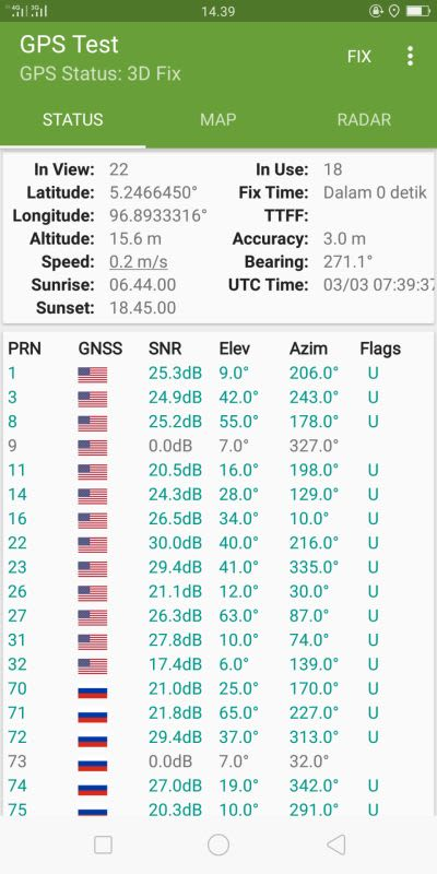
Mockups / Examples
This is a sample image after the developer adds the "Show KML file on map" feature and features "calculate waypoint-to-waypoint distance and direction" in the gps test application


Benefits
Features Show KML file on map allows users to be able to collect coordinate data from the ground on the coordinate system that the user wants and choose from a defined system. Users can also view coordinate data on the map and also users can search by address and see that on the map. Users can learn the value of point and distance height between the point and location of the current user by tapping on the map. And users can also see the distance and the elevation difference between the two points made on the map. Users can convert existing coordinates to other coordinate systems in geographic information systems (GIS). The calculate waypoint-to-waypoint distance and direction feature makes it easy for users to use and work even in remote countries because it does not require network connectivity so users can use it with user paper topographic maps. Waypoints and track logs recorded in the field can be seen later in Google Earth. The user can also automatically calculate the local geoid offset to improve the altitude accuracy and also store the current user location as a waypoint, and record the track log to indicate where the user has been on the current user coordinate map, altitude, speed, direction of travel, and total distance travel in metrics includes an optional line timer to record the running duration and calculate the average speed. This is an exciting thing for other users using the gps test app and this is a wonderful thing.
Posted on Utopian.io - Rewarding Open Source Contributors
@mzeck, Upvote is the only thing I can support you.
Thank you for the contribution. It has been approved.
You can contact us on Discord.
[utopian-moderator]
Hey @mzeck I am @utopian-io. I have just upvoted you!
Achievements
Suggestions
Get Noticed!
Community-Driven Witness!
I am the first and only Steem Community-Driven Witness. Participate on Discord. Lets GROW TOGETHER!
Up-vote this comment to grow my power and help Open Source contributions like this one. Want to chat? Join me on Discord https://discord.gg/Pc8HG9x