Adsactly Education: Columbia River
The Columbia River rises up high in the Canadian Rockies and during it’s 1,243 mile journey to the Pacific Ocean becomes the 4th largest river by flow in North America and dumps more fresh water into the Pacific than any other river in North or South America.
It is at risk in several ways, some of which can be fixed and some that can’t. The story of the Columbia is intensely personal to me, I grew up in ‘The Big Bend’ region of Eastern Washington and could go north, south or west to find the river.
The River Runs It’s Course
Columbia Lake and the adjoining wetlands are the headwaters of the river in the Canadian Rockies. It runs roughly Northwest for it’s first 200 miles until it tumbles out of the Rockies and turns South. The river runs mostly south through eastern British Columbia before it enters the US near Kettle Falls. It continues to run south until it meets up with the Spokane River where it turns west.
The Columbia describes a huge C shaped course in Eastern Washington. West, then south before turning back to the east where it meets the Snake River and runs south to become the border between Washington and Oregon as it runs to the sea. It runs almost straight west to it’s mouth at Astoria, Oregon. The huge flow that is dumping into the Pacific and the shifting sandbars from the flow and the effect of the tides creates a difficult crossing for boats which is known to sailors as the Columbia Graveyard.
The Columbia has an average flow of 265,000 Cubic Feet Per Second at the mouth which makes it the largest river to empty into the Pacific from North or South America.
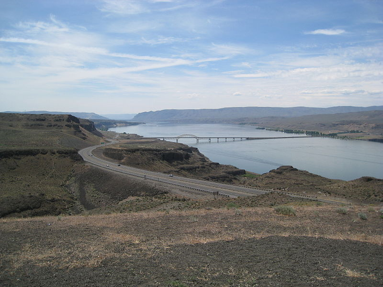
Columbia River Gorge courtesy the author
Geology
The geology of the Columbia River is relatively unique on earth. Millions of years ago the Pacific Northwest wasn’t a part of the continent that would become North America. The region was a series of islands whose tectonic plate crashed into the North American plate and dove under it from the force. Mountains rose, and the area fused into the NA plate completely. On the seam between the two was a ‘hot spot’ where the molten core of earth was (is) way closer to the surface than is normal. That ‘hot spot’ now is right under Yellowstone National Park.
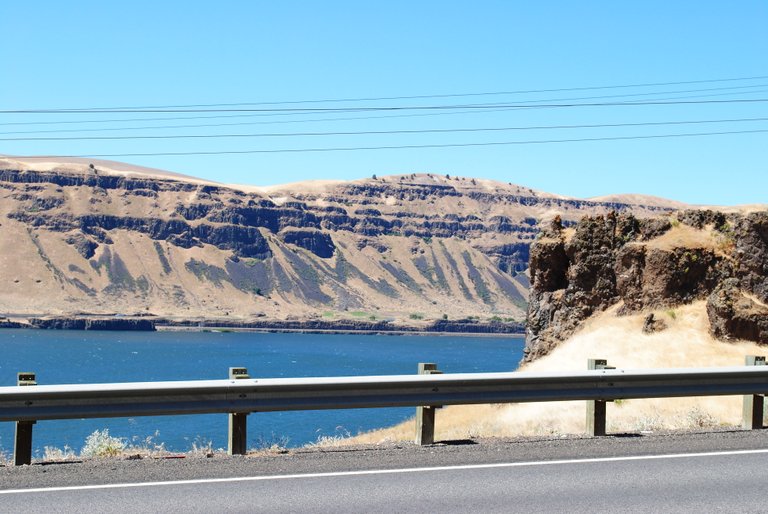
Columbia River Gorge courtesy the author
The consequence of this tectonic action was lava. Lots and lots of lava. Lava gushed out of the earth at an unprecedented rate and very nearly completely covered what would become the Pacific Northwest. In some places the lava was a relatively thin layer but most of the region would be covered by lava to the tune of hundreds of feet thick.
After a few millena, the plate has continued to move while the hotspot has stayed in the same place. The intense pressure of one plate diving under the other has eased and the lava flows , haven’t happened in quite a long time. Hundreds of thousands of years. The next pressure on the region would come from ice. A mile thick sheet of the stuff in the last ice age. The ice formed in the polar region and spread south, smoothing and cleaning everything in it’s path. In some places the ice gouged the lava beneath it and lots of what we see as lakes today were formed.
In time, the earth warmed and the ice started to retreat. You can plainly see places where the junk that the ice pushed along stopped moving, it is called the terminal moraine. As the world warmed more and more the ice retreated faster and faster. The water that was released needed a way to get to the sea, so the river channels were carved. The story would end there except that some of that water flooded much of what is now Montana. About 15,000 years ago the ice dam that held that huge lake back burst and an incredibly huge amount of water headed to the Pacific. The flood carved canyons and a secondary river bed that produced the largest waterfall that has probably ever existed on earth. It is now the largest dry waterfall on earth.
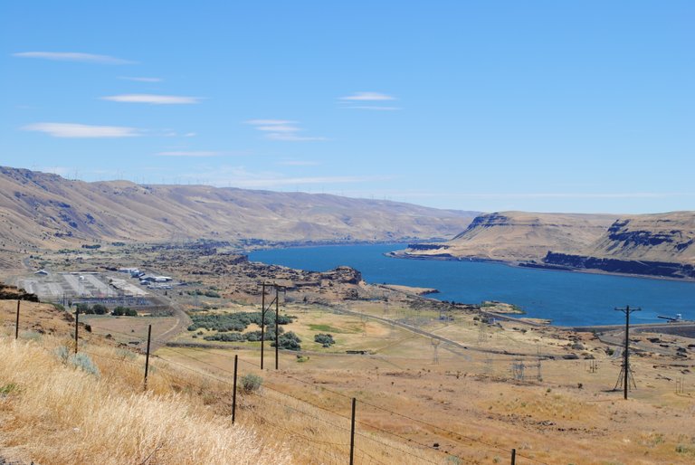
Columbia River Gorge courtesy the author
Today’s river uses some of both: The original channel that it cut over the millena and some of the ‘quick cut’ canyons carved out by the flood. Two other ‘recent’ events have had an impact: A monster landslide in the area of the present Bonneville Dam completely blocked the river for a period of time in the last 500 years changing the depth and direction of the channel, and the eruption of Mt. St. Helens in 1980 reduced the depth of the shipping channel in the lower Columbia by as much as 25 feet (8m). These events let us see the Columbia as a constantly changing entity.
History
Indigenous people have inhabited the Columbia River Basin for at least 15,000 years. Though the anthropologists used to say the people of the Americas came here over an ice bridge during the last ice age, the evidence is starting to say otherwise. The indigenous people claim to have been here before the land turned cold.
We do know that the Columbia and it’s tributaries provided a real network for trade and cooperation over a very large piece of land. The switch to a Salmon based economy caused them to become more sedentary. Most of the river had ‘villages’ that were little more than family units. Prime fishing locations were places not so much under tribal control as tribal administered. The family unit was primary on the river.
The more sedentary lifestyle led to more leisure time and with it art. Baskets and pottery used to store food in became works of art. Trade was carried out over a very wide area as witnessed by artifacts from all over the Western US being found in the Columbia River drainage.
The Natives started getting horses shortly after 1700. By 1730 both the Nez Perce and Piutes had horses and were starting to change their ways to account for the added mobility. The Nez Perce didn’t completely separate from their river cousins, but they started hunting and trading buffalo that they took east of the Rockies for fish and other artifacts.
The Natives continued to fish the river and it’s tributaries into the 1940s when the dams on the Columbia flooded their historic fishing grounds. Today the tribes are allocated one half of any given run up the river.
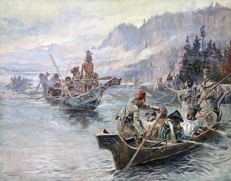
It is widely believed that Japanese and Chinese explorers reached the shores of North America possibly as early as 2000 years ago. Spanish refugees from California certainly reached the area of the River in the late 1600s, but the first recorded foreign sighting of the Columbia River is Bruno de Heceta of Spain who noted the river’s mouth in 1775. The search for the Northwest Passage led to many British and Spanish ships exploring the area.
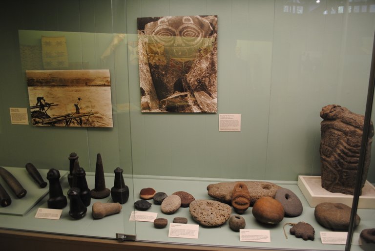
Tools of the River People courtesy the author
In 1792 American Robert Gray piloted the first ship to cross the bar and enter the Columbia River. Gray’s effort spearheaded the American claim to the region which was also claimed by Russia, Great Britain, Spain and France. The British believed that the Columbia was connected to the Missouri river and formed a true Northwest Passage.
The Lewis and Clark Expedition of 1803-1805 put that notion to rest. They left St. Louis, MO and returned there 3 years later with detailed maps and samples and drawings of fauna and flora. They also permanently cemented the US claim to the Pacific Northwest.
Trappers, traders and settlers soon started pouring into the region. Within 50 years of the Lewis and Clark expedition the territory was well known if not completely settled. Indian uprisings led to many battles between the US Calvary and some of the tribes, including the last one in the US between the Nez Perce and the Cavalry where Chief Joseph uttered his famous line “From where the sun stands now, I will fight no more forever.” 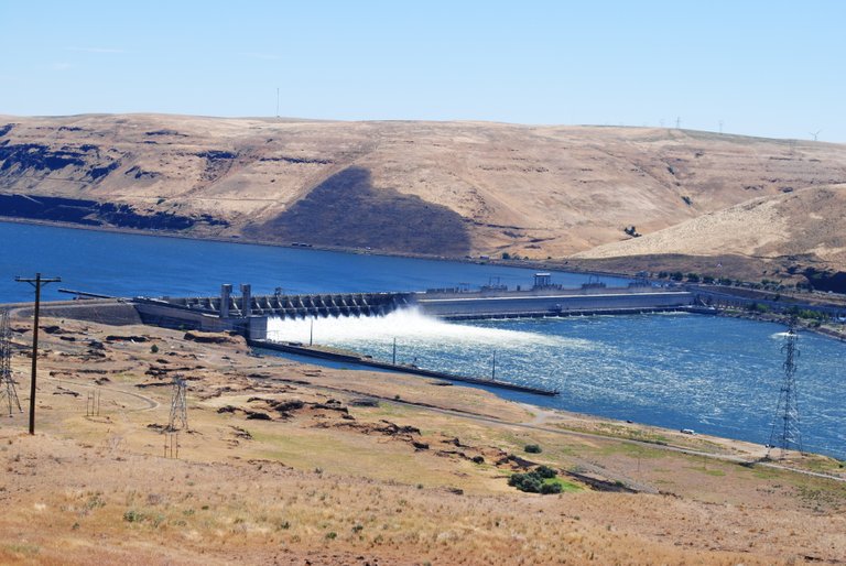
Taming the River
The taming of the river started in 1836 with the first Steamboat on the river, the Beaver operated by the Hudson’s Bay Company. Ships still had to cross the bar at the mouth of the river but could off load cargo in Astoria, Oregon and the Beaver (and soon others) would haul the cargo up to the Cascade Rapids. By the late 1850s there were Steamboats operating on many stretches of the river and the settlement was rapid.
Soon, leaders started talking about a channel all the way to Lewiston, Idaho. Jetties on the mouth and dredging the channel of the river started in the second half of the 19th Century. Cascade Locks by passed the Cascade Rapids in 1896. By 1915 the construction of dams and barriers had started in the river and navigation by tugs and barges to Lewiston was successful in 1975.
Other dams higher up on the river produce vast quantities of hydro power and provide recreation and flood control. They also killed the salmon runs above Grand Coulee Dam and have left the Columbia River with only one free flowing stretch, the Hanford Reach.
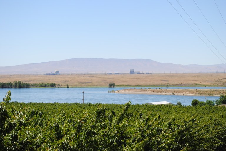
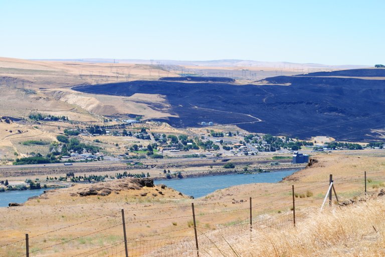
Hanford Reach courtesy the author
The Risks
Hanford. Used to be a little bitty town in Eastern Washington. It’s now a monstrous name in the minds of everyone that is anywhere near the river and a great many that aren’t.
Hanford, the town, ceased to exist early in the US involvement in WWII. A huge area in a hook in the Columbia River was taken by the US Government for ‘research purposes’. Turns out, the Hanford Reservation is where the government successfully created the Plutonium that was used in the first two (and all subsequent) nuclear bombs. It was an incredibly ambitious and secretive project that cost billions of dollars to provide the power that ultimately ended WWII.
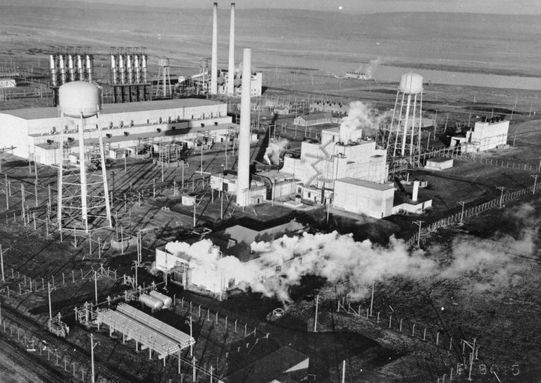
But the cost. Hanford Reservation is now the most nuclear polluted site in the country and there is some waste stored there that is not only toxic, it is deadly. The waste was originally stored in one million gallon tanks that are leaking today. The plume of incredibly deadly chemicals is making it’s way to the river. Can it be stopped in time?
The Government is plowing money into the area by the boatload. Several new double wall tanks are now in service and the transfer from the old tanks is underway, but it is a necessarily slow and costly process. There are multiple decommissioned reactors scattered around, and those always pose a risk, too.
There are still top secret areas in the Hanford Reservation where research and development goes on. It’s got to be done someplace, and Hanford is there. There is little doubt that the entire reservation is a huge economic engine for the Tri-Cities area.
There is a group of people mostly north of the Hanford Reservation that are called ‘the Hanford Downwinders’. The government released a certain amount of very toxic particles to the atmosphere during the 40s and 50s. Some were accidental, but most were deliberate to see just how they spread in the atmosphere. A relatively small number of people were directly exposed. I am one of those. I am a Hanford Downwinder.
All in all, the Columbia is a glorious and powerful river that is the heart of a huge region. It provides water for irrigation and drinking to millions of acres both directly and indirectly. It is so much a part of my past that it feels like a relative.
While the words and ideas in this post are strictly those of the author two sources were referred to by me to insure numerical and historical accuracy.
Wikipedia: Columbia River
American Rivers: Columbia River
Unsourced Photos are used courtesy of the author.
Authored by: @bigtom13
Click on the coin to join our Discord Chat

Witness proposal is here:
Go To Steem Witness Page
In the bottom of the page type: adsactly-witness and press vote.

Use small letters and no "@" sign. Or, click here to vote directly!
Thank you!
It saddens me to see capitalism trump environmentalism. Hanford was the worst thing to ever happen to the region. To this day the area you've described is absolutely stunning! Thanks for the history lesson!
Hanford is like a Neon sign in an out of the way roadhouse. It unfortunately shines brighter than anything in that part of the world.
I spent 10 days with my brother in Kennewick, Wa. due to a small problem with Connie. At least 5 of those days the headline in the local paper involved Hanford. It's a very quiet situation that is brewing there....
You have to wonder about how many areas and environments you would have never thought about you could say these things because of capitalism and industrialism. Our technological and financial advancement have cost us some pieces of true natural beauty.
Hello Sir @adsactly.education history...The rising temperature is a result of rising pollution!! It's time we should wake up.In the education process, a person is encouraged to develop the full potential of the underlying qualities and is assisted in achieving the skills needed for establishment as a productive member of society. Learning in the general sense is to acquire knowledge or skills. In a broad sense, learning is the process of knowledge-learning process.It means that the Columbia River has been the most important and intensive river of the West. It presents very awesome and eye touching scene that I have decided to visit it as soon as possible. But education is the continuous practice of developing full potential.Education is the first work.l like it this good education.Thank you for the very kind words.It's an incredibly delicate situation. Both sides have valid points. The good news is that so far, both sides are talking about what they might be able to agree on. Sir @adsactly. really valuable post.good analysis.
It is a delicate situation, and it feels from the outside that we are helpless.
Man this introduction to the Columbia river is so epic............ everything from its origin and geological history to its cultural impact has been mentioned. This was by no means a small post (at least 1500 words I think) but to cover so many things in just these amount of words is actually quite a feat. My congratulations to the author for that.
In the post the geological history of the formation of river and obviously the land was the most fascinating part for me. It was like walking through history and that was really a pleasure for me. The formation of the land mass and the appraoch of the ice age. Combined with tectonic pressure and movement ice - they all literally changes the face of the earth which included creation of ravines and canyons and other geological structures. Perhaps I am overly impressed because of my interest in Geography but there is no denying the grandness in the actions of nature.
The acts of nature are grand and unique but the geological history of anything in this world spans far beyond the human history and makes you realize that we are just specks in the bigger scheme of things.
I grew up in the area, in fact our particular area is known as the channeled scab lands. It is home, and so natural to me in so many ways. This post, in particular, was a labor of love. Not just love of providing information but showing off where I grew up.
The Columbia is a great river, it provided food to the Native Americans for years, and still provides Washington and Oregon with so much culture and activity. I'm blessed to have grown up in Portland and had easy access to the Gorge my entire life.
One of the most interesting stories that was not included in your post, was Celilo Falls. Although, I am thankful for the cheap power harvested by the dams, I wish I could have seen Celilo Falls and the salmon jumping up over the falls to their next spawning ground.
My favorite Oregon Columbia River city is Hood River (fun fact: the only city in Oregon that allows you to have an open container) , followed by Astoria. I haven't frequented that many in Washington, but I thought Crescent Bar was beautiful. What're your favorites?
This post ran right at 2000 words. I had to not say things rather than find more to say. I don't actually remember Celilo falls, but I certainly heard about them every time by. At least twice a year through my youth. My great grandmother lived in NE Portland and my father had an aunt and an uncle that lived there.
My favorite Oregon city probably has to be Pendelton. My mother was born there :) My Grandmother went to school in the Dalles and met my Grandfather there. Her grandparents homesteaded in Wasco County (near Antelope) and ended up near Pilot Rock. So, you see, I am connected to this river. End to end.
Thanks for the wonderful comment. I really do appreciate it.
This river has a ton of history
Yes it does. Some of the longest history in the Americas.
It's a very fine journey. This journey took us all along the course of the river. We traveled through the gorge of the river in various time periods. However, this point attracted my attention..
If a democratically formed government can do this to its citizen, what else can be expected from a tyrant and despotic ruler? I am forced to say that there is no democracy in this world. People don't choose their leaders, they choose their masters.
You got a $10 bounty for returning the tracking balloons during the early 50s. My dad found at least 3 in the course of farming our farm. We are pretty sure one was from the infamous Strontium 90 release (intentional).
Pretty sad commentary indeed.
It was very sad event!
The USA government making money out of a dangerous situation and knowingly putting millions of people in danger.
We need to ban the USA government
That's probably not likely :) I honestly believe that they are being a lot more open about what is going on and what has been going on there in the past. But there is no doubt, the situation is dangerous.
Enlightement Post.
The role of the river is very large and menjaddikan one of the vein of life of society and perindutrian certainly a contribution that can not be denied. The Columbia River performs well with a blessing for the people living along the banks of the river. As a means of irrigation of water, this river makes the farm more secure the availability of water. Similarly, the industry and hydroelectric power plants produce electricity to meet the needs of the community.
The role of this river has begun from antiquity so that now we stay and continue to maintain its sustainability.
unfortunately, the pollution generated from the development of the nuclear industry and indutsri which produces waste dumped into the river to watch out because it can pose a great danger to our survival in the future.
This post reminds us to continue to preserve the river that has provided many benefits.
Thank you @bigtom13
Thanks @adsactly
Thank you Steemit
Warm regard from indonesia
Thank you for the kind words. When I first proposed this series I really thought that the Colorado would be the highlight for me as a writer. Not so. I grew up near the Columbia and could have written lots more. It is like it is a part of me, or maybe more correctly I am a part of it.
Your post explain well then i know it's your habitat. And you can explore better. You are not only writing but also educate.
Salute....
I know this river as the largest river on the Pacific coast of the United States. Now, thanks to your message, I know that this is a river with a long history and unfortunately environmental problems. I'm always against human carelessness. It's sad to see how the monetary interests of a group of people become ahead of the environment. I first read about the Hanford Reservation, before that I did not know about its existence.
Thank you for an interesting and informative article!
Thank you for the kind words. Hanford was a well kept secret for a lot of years, during which time an incredible amount of nuclear waste was stored pretty haphazardly.
We lived within about 50 miles and had no real idea what went on there until the 1970s. The pile of Freedom of Information Act (FOIA) forms that were filed by groups and individuals was epic, and the government really drug their feet on them siting National Security.
@adsactly Thank you very much for sharing this informative article. It means that the Columbia River has been the most important and intensive river of the West. It presents very awesome and eye touching scene that I have decided to visit it as soon as possible. The photo you shared really shows dominant features of the Columbia River has been the most important and intensively used this great River.
Followed you, upvoted and resteemed you article as usual..
It is intensively used. For so many purposes. One thing to remember is that it is a huge money generating machine. So much hydro power and industry that are tied to this river.
Great effort by the government for preserve and make sure water comes to everyone from the river , this is good information to keep myself updated. With Columbia river thank you bro
Upvote For Upvote And Reply My Comments
I really do hope the government has the upper hand in this battle with a problem they created.
"The family unit was primary on the river"
Great phrase @adsactly
Thanks for sharing this great blog
Have a Blessed week
This river system was/is unique in the indigenous world. People have been making a living, a good living on the banks of this river for a long, long time. Families ruled the ground and the various tribes were more 'administrative' here than anyplace else. Family is still incredibly strong on the reservations up and down the river.
Thanks for sharing your thoughts with me @bigtom13
Have a great Day and keep in touch
Feel free and enjoy my art/music from my pages
Regards
Yeah, Columbia River is one of the largest River in Pacific Northwest zone that rises in Rocky mountain.. Also the history of this River is amazing and interesting. I had little knowledge about this and I got more information by reading this post.
Thanks for sharing information about one of the largest and oldest River in world
Posted using Partiko Android
It is incredibly important to a large fraction of North America. Crops and materials move both ways and drive an economy that is much larger than the drainage basin.
Wow that's great post....I appreciate your history and beautiful education..
Thanks for sharing this steemit blog.... give me a upvote done.... good luck@adsactly sir.....
Thank you very much..
Nice post
This photo is very beautifull and your post is great.@adsactly
Very beautiful and informative post. I selected you for vote for witness @absactly.
Such a big river.
Wonderful write up.
Education is the first work.l like it this good education.
Thanks for sharing this history...best of luck@adsactly sir... give me a upvote done sir....
The rising temperature is a result of rising pollution.... It's time we should wake up.
Historical river!
Excellent history of an interesting river. Thanks for sharing.
@adsactly , its a valuable post , i had little knowledge about this river but now got more after reading this post .I appreciate you for sharing this post.