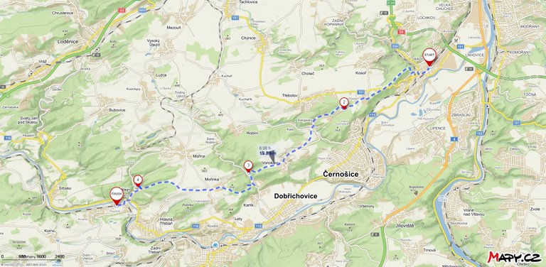
Like 14 days ago, I didn't know what to do with Sunday. After lunch, I started thinking that I didn't want to sit at home, so I looked at the map and found that from Prague Radotín, the European route E10 leads south to Karlštejn Castle. I packed my things and set off in the direction of Radotín. Buses run from Smíchov Railway Station and the journey takes about 15 minutes. I was on the spot slightly before two in the afternoon. I started the journey along the red path and, as usual, uphill.
Jako před 14 dny jsem nevěděl co s načatou nedělí. Po obědě jsem začal přemýšlet že se mi nechce sedět doma a tak jsem koukl do mapy a našel, že z Prahy Radotína vede Evropská trasa E10 směrem na jih na hrad Karlštejn. Sbalil jsem si věci a vyrazil směr Radotín. Autobusy jedou ze Smíchovského nádraží a cesta trvá asi 15 minut. Na místě jsem byl lehce před druhou odpolední. Zahájil jsem cestu po červené stezce a jako obvykle do kopce.

After a while it is possible to turn to the lookout, but there is nothing interesting, it is only possible to sit on a wooden bench and relax after climbing the hill. Then the road leads through the protected area Staňkovka where Mouflon and rare predator Beeeater (Pernis apivorus) live. When the forest ends, you go out on the meadows where the horses graze and there is also a view of the Cukrák tower.
Po chvilce je možné odbočit na vyhlídku, ale není zde nic zajímavého, jen je možné posedět na dřevené lavici a odpočinout si po výstupu do kopce. Poté cesta vede chráněným územím Staňkovka kde žijí Mufloni a vzácný dravec Včelojed ( Pernis apivorus). Když skončí les vyjdete na loukách kde se pasou koně a je zde i výhled na věž Cukrák.
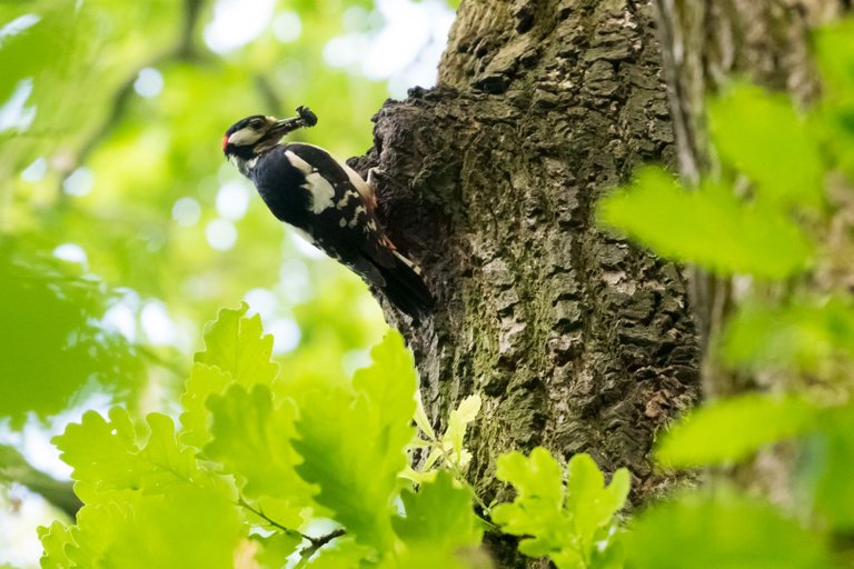
The road continues through forests and villages in the Central Bohemian Region, some of which are still historic, even though there is a lot of construction. Another of the more challenging sections is Karlické údolí, where it is possible to visit the castle ruins, but there are only a few remaining walls. After conquering the valley, you will find yourself in an oak forest where there are many birds. I've been trying to take a picture of the Great Spotted Woodpecker for several weeks now. This time I was lucky to hear the calls of young spotted woodpeckers. I found a tree where they had a nest and waited for one of the parents to arrive with food.
Cesta dále pokračuje přes lesy a vesnice ve Středočeském kraji, některé z nich mají stále historický ráz i když zde probíhá hojná výstavba. Další z náročnějších úseků je Karlické údolí, kde je možné navštívit zříceninu hradu, ale je zde jen pár zbylých zdí. Po zdolání údolí se ocitnete v dubovém lese kde je spousta ptáků. Už několik týdnů se snažím vyfotit Strakapouda velkého. Tentokrát jsem měl štěstí, že jsem zaslechl volání mladých strakapoudů. Našel jsem strom kde měli hnízdo a čekal až přiletí jeden z rodičů s potravou.
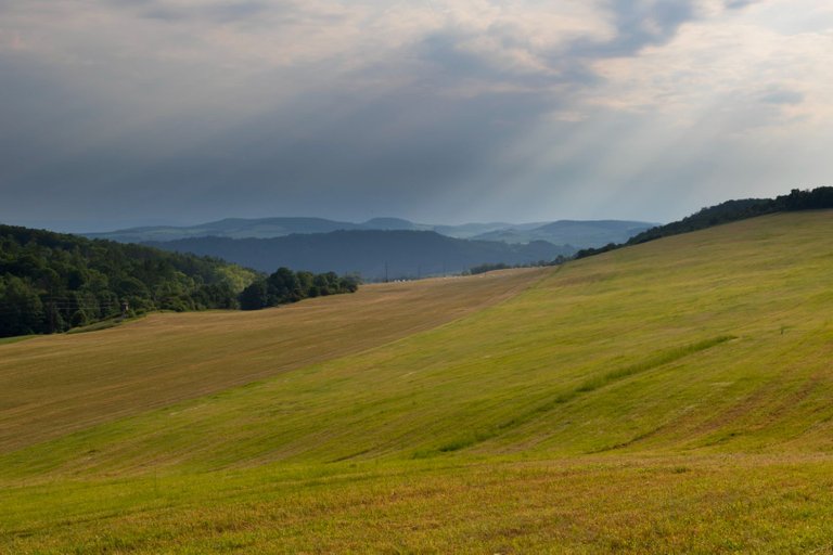
The final part of the road leads through the meadows behind the village Mořinka. However, the path goes through the vegetation, which creates a natural tunnel, which beautifully protects from the afternoon sun. Sometimes you can go out and look around the region.
Závěrečná část cesty vede loukami za obcí Mořinka. Jenomže cesta jde skrze porost, který vytváří přírodní tunel, který krásně chrání před odpoledním sluncem. Občas se dá vyjít ven a rozhlédnout se do kraje.
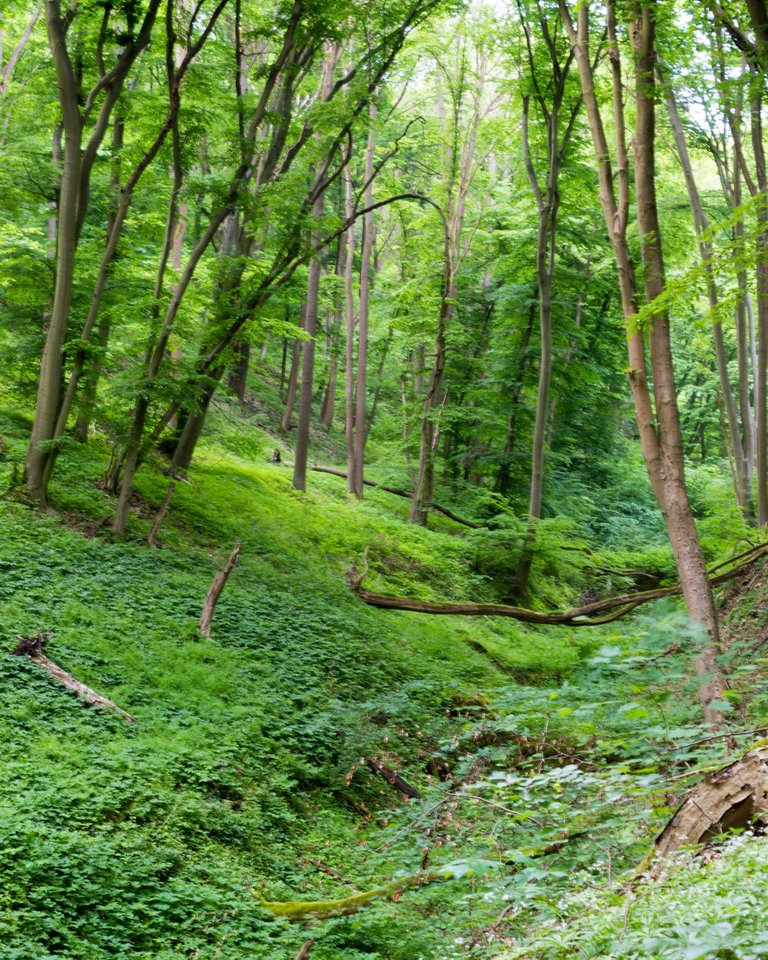
The very last section of the road is downhill through the Karlštejn Nature Reserve, where mostly beeches, oaks and hornbeams grow, sometimes there is a conifer. The closer you are to the village of Karlštejn, the older and more interesting the forest is, unfortunately I did not have the time for photography of the details. When the forest spreads out, you will see the medieval castle of Karlštejn.
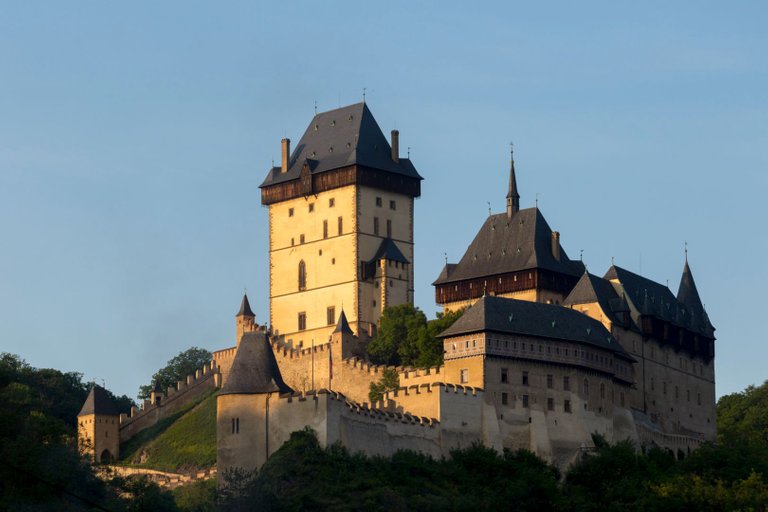
Úplně poslední úsek cesty je z kopce skrz Přírodní rezervaci Karlštejn, kde rostou převážně buky, duby a habry, občas je zde nějaký jehličnan. Čím blíže jste k obci Karlštejn tím je les starší a zajímavější, bohužel jsem neměl čas a focení detailů. Když se les rozestoupí ukáže se Vám středověký hrad Karlštejn.
From the castle it is about 2 kilometers through the village to the station. The road measured a total of 20 km and it was another section that I conquered on the E10. Below are links to other sections I went through last year. And next weekend I will probably continue from Karlštejn to Kamýk nad Vltavou. That is, from the Berounka river to the Vltava river through the Brdy highlands.
Od hradu je to skrze vesnici k nádraží asi 2 kilometry. Cesta celkově měřila 20 km a jednalo se o další úsek který jsem na E10 pokořil. Níže jsou odkazy na další úseky, kterými jsem prošel minulý rok. A o následujicím víkendu asi budu pokračovat z Karlštejna do Kamýku nad Vltavou. Tedy od řeky Berounky k řece Vltavě přes vrchovinu Brdy.
Previous sections
Další pěkný výlet. Těžko se mi bude vybírat jen jedna fotka do soutěže :-)
!BEER
za použití #aroundtheworld
Mám v plánu letos docela dost cestovat po ČR, takže to se mnou nebudeš mít jednoduchý :D
Budu si muset poradit :-)
View or trade
BEER.Hey @softa, here is a little bit of
BEERfrom @bucipuci for you. Enjoy it!Learn how to earn FREE BEER each day by staking your
BEER.Nejhezčí pohled na hrad v kopcích za Třebání...
Bez stánků a městečka.
Stánky jsou všechny pryč a město je úplně mrtvý i v neděli. Jen 3 otevřený restaurace. Ten od Třebáně znám, někde v daleký historii ho zde mám i fotku. Dobrej pohled je i z golfovýho hřiště, ale tam útočí golfisti a ochranka.
:) To věřím, že teď je v podhradí vymeteno. Počítám, že to brzy zas ožije.