Diversity Of (7)Rivers In Myanmar Country
English Version
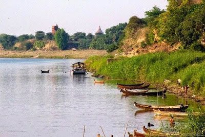
(1) The Irrawaddy River Irrawaddy River basin (413, 674 square kilometers), Myanmar (61) percent of the total area of coverage. The country's most important commercial waterways, such as the length of the Irrawaddy River (2, nearly 17 kilometers) long. Unique appearance, at any point along the Irrawaddy River Tagaung one click, Bagan, Sai, see Sagaing, Inn 0 Myanmar Emergence of culture found in Myanmar culture has flourished in Myanmar Myanmar culture and history means for the future Irrawaddy speaking culture. (2) The Chindwin river Chindwin ဧရာဝတီမြစ်အတွင်း flows, is the largest river watershed 1,207 km long. Chindwin River in Kachin State in the broad plains of Burma Valley origin, whilst insurer, Hebrew, Wang, Sharon comes occur together. Chindwin rivers. The tip of the country's famous jade mines ဥရုချောင်း myth. Distinct yet to apply the Chindwin low Htamanthi Reserve and army descended through the Valley Tiger Reserve and this tiger is a protected forest, the world's largest tiger reserve. In addition, the other is about to disappear from the wild animals are rare species, Tiger, elephants, The country has relied on the nuts roll areas. (3) the Salween river in Myanmar's Shan State and Karenni state east of the river flows through. The total length is 1749 miles (2815 km) flows in Southeast Asia's second-longest river. A collection of the world's most diverse river inhabited by the river. Remarkably unique is the historical significance of the area before historical fossils have been found, as well as Southeast Asia and began developing the original documents. (4) စစ်တောင်းမြစ် စစ်တောင်းမြစ် Shan highland origin, boosting the edge length of 261 kilometers (420 miles) south of Bangladesh boosting the sea An integrated flow in the Gulf of Martaban. Remarkably unique point စစ်တောင်းမြစ် 25-mile (40-kilometer) journey on the ship can travel the whole year, 55 km (90 miles) journey can travel the journey of 3 months of the year. (5) Mekong River has a length of 4,800 kilometers, the Mekong River as the border between Burma's Shan State and Laos Mekong flows through the length of 234 kilometers. On the mountains of the Mekong River flows through the country's estimated 22,000 indigenous being inhabited, Shan, Lahu, (Sam), easy China Inn ethnic population. Myanmar-Thailand-Laos 3 passes over the "Golden Triangle" at the intersection. The significant point ရိုးရာပုံပြင်များ first feature of security people, they say, are derived from these rises Traditional songs, Stories of this river is often quoted expression. (6) Kaladan Kaladan is the state's longest and most useful is a slender river. This river is high (8,000 feet) long frontier with India, Chin increase in flow from the hills of England origin. Remarkably unique point in northern Chin State (O) Name the river which flows through the river bordering India and Myanmar. (7) Gold River Gold River, China Yunnan originated boosting the city through the northern Shan State Tagaung kilometers south of the city, only 60 minutes north of the Irrawaddy River Inn near the village and meet. Distinct tribes apply until the Ruili River, also called Burma, Shan, and have a great relationship. Found a rare species of aquatic birds numbered Ruili River and Irrawaddy dolphins are found occasionally. Note.. Unique information extracted from the notebook. Credit to Omar

Myanmar Version
ျမန္မာျပည္မွ ထူးျခားေသာ ျမစ္ (၇)စင္း (၁) ဧရာဝတီ ျမစ္ ဧရာဝတီ ျမစ္ဝွမ္းသည္ (၄၁၃, ၆၇၄) စတုရန္းကီလိုမီတာ က်ယ္ဝန္းၿပီး ျမန္မာႏိုင္ငံ စုစုေပါင္း အက်ယ္အဝန္း၏ (၆၁) ရာခိုင္ႏႈန္းကို လႊမ္းျခံဳထားပါသည္။ တိုင္းျပည္၏ အေရးအႀကီးဆံုး ကူးသန္းေရာင္းဝယ္ေရး ေရေၾကာင္းလမ္းျဖစ္သည့္ဧရာဝတီျမစ္သည္ ျမစ္ေၾကာင္းအလ်ား(၂, ၁၇ဝ) ကီလိုမီတာနီးပါး ရွည္လွ်ားပါသည္။ ထူးျခားထင္ရွားသည့္ အခ်က္မွာ ဧရာ၀တီျမစ္ႀကီး တစ္ေလွ်ာက္တြင္ တေကာင္း၊ သေရေခတၱရာ၊ ပုဂံ၊ ျမင္စိုင္း၊ စစ္ကိုင္း၊ အင္း၀ စသည္႕ႃမန္မာ့သမိုင္း၊ ျမန္မာ့ယဥ္ေက်းမႈတို႕ ေပၚထြန္းခဲ့ၿပီး ျမန္မာ့ ယဥ္ေက်းမႈမ်ား ထြန္းကားလာခဲ့သည္ကို ေတြ႕ရသည့္အတြက္ ႃမန္မာ့သမိုင္း၊ ျမန္မာ့ယဥ္ေက်းမႈ ဆိုသည္မွာ ဧရာ၀တီသမိုင္း၊ ဧရာ၀တီယဥ္ေက်းမႈဟုေျပာလို႔ရပါသည္။ (၂) ခ်င္းတြင္း ျမစ္ ခ်င္းတြင္းျမစ္သည္ ဧရာဝတီျမစ္အတြင္း စီး၀င္သည့္ အႀကီးဆံုးေရေ၀ျမစ္ ျဖစ္ၿပီး၊ ၁,၂၀၇ ကီလိုမီတာ ရွည္လ်ားပါသည္။ ခ်င္းတြင္းျမစ္သည္ ကခ်င္ျပည္နယ္ရွိ က်ယ္၀န္းသည့္ ဟူးေကာင္းခ်ဳိင့္၀ွမ္း လြင္ျပင္တြင္ ျမစ္ဖ်ားခံၿပီး တႏိုင္း၊ တျဗဲ၊ တ၀မ္၊ တရြန္ျမစ္မ်ား စုဆံု၍ ခ်င္းတြင္းျမစ္ ျဖစ္ေပၚ လာပါသည္။ ျမန္မာႏိုင္ငံ၏ နာမည္ေက်ာ္ ေက်ာက္စိမ္းတြင္းမ်ားသည္လည္း ဥရုေခ်ာင္းဖ်ားတြင္ တည္ရွိေနၾကပါသည္။ ထူးျခားထင္ရွားသည့္ အခ်က္မွာခ်င္းတြင္းျမစ္ သည္လူအထိအေတြ႔နည္းေသးေသာ ထမံသီ ေဘးမဲ့ေတာႏွင့္ ဟူးေကာင္းခ်ဳိင့္၀ွမ္း က်ားေဘးမဲ့ေတာမ်ားကို ျဖတ္သန္းစီး ဆင္းေနျပီး ဤက်ားေဘးမဲ့ ေတာသည္ ကမၻာေပၚတြင္ အႀကီးဆံုး က်ားေဘးမဲ့ေတာလည္း ျဖစ္ပါသည္။ ထို႔အျပင္ အျခား သားရိုင္းတိရိစၧာန္မ်ား ျဖစ္ၾကသည့္ ရွားပါးေပ်ာက္ကြယ္ေတာ့မည္ျဖစ္ေသာ မ်ဳိးစိတ္မ်ား၊ က်ားမ်ား၊ ဆင္မ်ား၊ ျမန္မာ ႏိုင္ငံတြင္သာ ရွိသည့္ အခြံမာလိပ္မ်ဳိးမ်ား အတြက္ ခိုလႈံေနထိုင္ရာ ေဒသတခုလည္း ျဖစ္ပါသည္။ (၃) သံလြင္ျမစ္ သံလြင္ျမစ္သည္ ျမန္မာႏိုင္ငံ၏ ရွမ္းျပည္နယ္ႏွင့္ ကရင္နီျပည္နယ္မ်ားကို ႏိုင္ငံ၏ အေရွ႔ဖက္မွ ျဖတ္သန္းစီးဆင္းပါသည္။သံလြင္ျမစ္၏ စုစုေပါင္းအရွည္သည္ ၁၇၄၉မိုင္ (၂၈၁၅ကီလိုမီတာ) ရွိျပီး အေရွ႔ေတာင္အာရွေဒသတြင္ ဒုတိယအရွည္လ်ားဆံုး စီးဆင္းေနသည့္ ျမစ္တစ္စင္းလည္း ျဖစ္ပါသည္။ သံလြင္ျမစ္သည္ ကမၻာေပၚတြင္ လူမ်ဳိးကြဲမ်ား အမ်ား ဆံုး စုစည္းမွီတင္းေနထိုင္ေနသည့္ ျမစ္တစင္းလည္း ျဖစ္ပါသည္။ ထူးျခားထင္ရွားသည့္ အခ်က္မွာသမိုင္းအရ အေရးပါသည့္ ေဒသျဖစ္ျပီးသမိုင္းမတင္မီ ရုပ္ႂကြင္းမ်ား ေတြ႔ရွိရသည့္အျပင္ အေရွ႔ေတာင္အာရွေဒသတြင္ လူစတင္ဖြံ႔ၿဖိဳးသည့္ မူလအေထာက္အထားလည္း ျဖစ္သည္ဟု ဆိုၾကပါသည္။ (၄) စစ္ေတာင္းျမစ္ စစ္ေတာင္းျမစ္သည္ ရွမ္းကုန္းေျမျမင့္အစြန္းမွ ျမစ္ဖ်ားခံစီးဆင္းလာၿပီး ေတာင္ဖက္သို႔ ၂၆၁ မိုင္ (၄၂၀ ကီလိုမီတာ) အရွည္ စီးဆင္းလာၿပီး ဘဂၤလားပင္လယ္အတြင္းသို႔ မုတၱမပင္လယ္ေကြ႔၌ စီးဆင္း ေပါင္းစပ္သြားပါသည္။ ထူးျခားထင္ရွားသည့္ အခ်က္မွာ စစ္ေတာင္းျမစ္တြင္ ၂၅ မိုင္ (၄၀ ကီလိုမီတာ) ခရီးကို တႏွစ္ပတ္လံုး ေရလမ္းခရီးသြားလာႏိုင္ၿပီး မိုင္ေပါင္း ၅၅ (၉၀ ကီလိုမီတာ) ခရီးကို တႏွစ္တြင္ ၃-လၾကာမွ် ေရလမ္းခရီး သြားလာႏိုင္ပါသည္။ (၅) မဲေခါင္ ျမစ္ မဲေခါင္ျမစ္သည္ အရွည္ ၄,၈၀၀ ကီလိုမီတာ ရွိျပီး ႃမန္မာႏိုင္ငံ၏ ရွမ္းျပည္နယ္ႏွင့္ လာအိုႏိုင္ငံ အၾကားတြင္ မဲေခါင္ျမစ္သည္ နယ္နိမိတ္အျဖစ္ ကီလိုမီတာ ၂၃၄ အရွည္ ျဖတ္သန္း စီးဆင္းပါသည္။ မဲေခါင္ျမစ္ ျဖတ္သန္းစီးဆင္းရာ ျမန္မာႏိုင္ငံ၏ ေတာင္တန္းမ်ားေပၚ၌ ဌာေနတိုင္းရင္းသား ၂၂,၀၀၀ ခန္႔ မွီတင္းေနထိုင္ လွ်က္ ရွိ ျပီး အခါ၊ ရွမ္း၊ လားဟူ၊ လြယ္လ (ဆမ္ေတာင္)၊ တရုတ္ႏွင့္ အင္း တိုင္းရင္းသားမ်ား ေနထိုင္လွ်က္ ရွိသည္။ ျမန္မာ-ထိုင္း- လာအို ၃-ႏိုင္ငံ ေပါင္းဆံုရာ "ေရႊႀတိဂံ ေဒသ"ကို ျဖတ္သန္းပါသည္။ ထူးျခားထင္ရွားသည့္ အခ်က္မွာ ေရွးရိုးရာပံုျပင္မ်ားအရ ေရွးဦးလားဟ ူလူမ်ဳိးမ်ားသည္ ဤျမစ္ဖ်ားခံရာ ေဒသမွ ဆင္းသက္လာၾကသည္ဟု ဆိုၾကၿပီး၊ ရိုးရာ သီခ်င္းမ်ား၊ ပံုျပင္မ်ားက ဤျမစ္ကို ကိုးကား၍ ေဖာ္ျပေျပာဆိုေလ့ ရွိ ၾကပါသည္။ (၆) ကုလားတန္ျမစ္ ကုလားတန္ျမစ္သည္ ရခိုင္ျပည္နယ္၏ အ႐ွည္ဆံုးႏွင့္ အသံုးအဝင္ဆံုးျမစ္ေၾကာင္း တစ္သြယ္ ျဖစ္ပါသည္။ ဤျမစ္သည္ ေပ(၈၀၀၀)ခန္႔ျမင့္ေသာ ခ်င္းျပည္နယ္ လူ႐ွည္ေတာင္တန္းႏွင့္ အိႏၵိယႏိုင္ငံ ခ်င္လတိတလန္ ေတာင္ကုန္းမ်ားမွ ျမစ္ဖ်ားခံ စီးဆင္းလာပါသည္။ ထူးျခားထင္ရွားသည့္ အခ်က္မွာ ခ်င္းျပည္နယ္ ေျမာက္ပိုင္းမွ ထေရာဘာ (တီအိုရီဘာ)အမည္ျဖင့္ စီးဆင္းလာသည္႔ ႃမစ္ျဖစ္ျပီး အိႏၵိယႏိုင္ငံ ႏွင္႔ ျမန္မာႏိုင္ငံတို႕၏ နယ္ျခားျမစ္လည္းျဖစ္ပါသည္။ (၇)ေရႊလီ ျမစ္ ေရႊလီျမစ္သည္ တရုတ္နိုင္ငံ၊ ယူနန္ျပည္နယ္မွပင္ စတင္ျမစ္ဖ်ားခံ စီးဆင္းလာၿပီး ရွမ္းျပည္နယ္ ေျမာက္ပိုင္းကို ျဖတ္သန္းလာကာ တေကာင္းၿမိဳ႕ေျမာက္ဖက္ ကီလိုမီတာ၆၀ခန႔္ အကြာ ကသာၿမိဳ႕ ေတာင္ဖက္ရွိ အင္းရြာအနီးတြင္ ဧရာဝတီျမစ္ႏွင့္ ေပါင္းဆုံသည္။ ထူးျခားထင္ရွားသည့္အခ်က္မွာ ေရႊလီျမစ္သည္ တိုင္အႏြယ္မ်ားဟုလည္းေခၚသည့္ ျမန္မာနိုင္ငံတြင္းရွိ ရွမ္းလူမ်ိဳးမ်ားႏွင့္ ႀကီးမားေသာ ဆက္ႏြယ္မွုရွိပါသည္။ ရွားပါးစာရင္းဝင္ ေရေနငွက္မ်ိဳးစိတ္မ်ားကို ေရႊလီျမစ္အတြင္း ေတြ႕ရွိရသည္႔အျပင္ ဧရာဝတီ လင္းပိုင္မ်ားကိုလည္း ရံဖန္ရံခါေတြ႕ရေလ့ရွိပါသည္။ မွတ္ခ်က္။။ မွတ္စုစာအုပ္မွ ထင္ရွားသည့္ အခ်က္အလက္မ်ားကို ေကာက္ႏုတ္ထားပါသည္။ Credit to ဥမၼာဦး