This is a continuation from the first post series of 39. Please read them in order.

Introduction
In ancient times people were very familiar with the Sun and the stars. At night they had nothing better to do than gaze up at the stars. They saw how the stars move across the sky during the night, and how different constellations are visible at different times of the year.
They made up stories which were allegories based on what they saw. Later on, these stories took on a life of their own, as the stories were passed down from generation to generation but the knowledge of what the stories represented was lost. People started believing the stories were real and actual history of events that actually really happened in the past, when originally the stories were nothing more than allegories for what people saw happening in the stars.
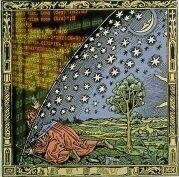
The ancients looked to the sky to determine what time of year it was. It was important to know what time of year it was. You needed to know when it was time to plant crops and when it was time to harvest the crops. As the year passed the Sun appears to make a journey through the constellations of the Zodiac. The entire story of Jesus’ ministry is an allegory for this journey.
Lesson 7: Latitude of the "Holy" Lands
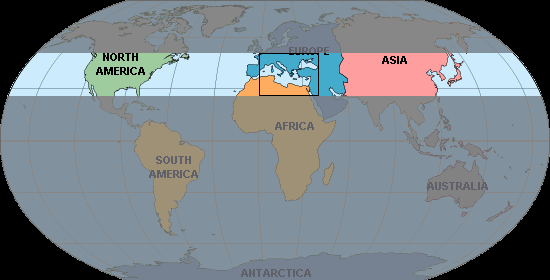
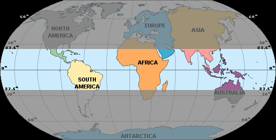
We digress here for a moment to note where the Holy Lands are positioned on the earth. Your Bible may have some maps in it showing the Holy Lands. The area is always that surrounded by the Mediterranean Sea. Egypt is at the bottom, Israel is on the left, Rome is the foot shaped piece of land at top. Somewhere around here is where all the Bible stories were written, and what we are most interested in observing about this region is what most people never pay any attention to. We are interested in the latitude of this region, because the latitude determines what stars you can see and what seasons of the year you experience.
The Holy Land region is approximately between 25° and 50° North latitude. This is important because this is the latitude where the familiar seasons of the year exist, with the shortest day of Winter occurring in December and the longest day of Summer occurring in June. This region also conveniently contains the United States of America where a lot of Christians live. If you happen to live in this latitude range then you're lucky, you're already familiar with the same seasons of the year the ancient writers of the Bible experienced, and you can go outside any night and see the same stars they saw.
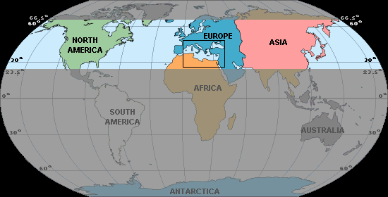
The range where we have the well known seasons of the year with Winter in December and Summer in June extends from 23.5° North latitude, known as the "Tropic of Cancer," up to 66.5° North latitude, known as the Artic Circle. The "Tropic of Cancer" is named after the zodiac constellation Cancer, for reasons that will become apparent later on.
As we head further North in this range the shortest day of the year, known as the Winter Solstice (around December 22), gets shorter and shorter, and the longest day of the year, known as the Summer Solstice (around June 21), gets longer and longer. When we reach the Artic Circle, at 66.5° North latitude, the shortest day of the year becomes so short the Sun actually never rises on that day, and the longest day of the year becomes so long the Sun actually never sets on that day.
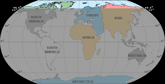
If we continue further North, above the Artic Circle (66.5° North latitude), we find there is a period of perpetual dark days centered around the Winter Solstice (December 22) when the Sun never rises, and a period of perpetual light days centered around the Summer Solstice (June 21) when the Sun never sets. As we move further North the number of dark days centered around the Winter Solstice increase and the number of bright days centered around the Summer Solstice also increase. When we finally reach the North Pole this pattern reaches its extreme — we end up with one long period of darkness lasting half a year, and one long period of light lasting half a year. At the North Pole the sun rises around March 21, and just circles around the horizon day after day for half a year, never setting. Around September 23 the sun sets, not to be seen again until March 21 of next year.

This is a good time to expose one of the misconceptions about the North Pole propagated by all the TV specials about Santa Claus we see each year in December. For example, a scene from "Rudolph the Red Nosed Reindeer," a classic 1964 television special. Examine closely this picture and see if you can find everything that is wrong with it. First we have snow. OK, they got this part right, there is snow at the North Pole. Then we have a flying reindeer who has a headlight for a nose — OK maybe that's a bit of fancy. And we have an Elf. They're always short, I don't know why, and they love to make toys for children. — Sure, I don't see why not. OK, do you see what else is wrong with this picture? Look closely. Note the tree growing in the background. Actually there are no trees at the North Pole. The show would have you believe there's a whole forest of trees growing at the North Pole, but actually there's none. There's still one more huge error in this picture. Do you see it? Let me give you a hint: can you see anything? What time of year is it? It's December. Where are we? At the North Pole. What's wrong with this picture? The picture portrays the North Pole as being a bright sunny place in Winter when actually the sun set three months ago and won't be seen again for three more months! That's right, Santa Claus lives in the dark.
Santa should really move to the equator where it's sunny all year 'round. He could swim in the warm tropical waters and maybe lose some weight. And what's with that "Ho! Ho! Ho!" laugh? Real people don't laugh like that.
When you think of it none of the Santa Claus story makes any sense. All children eventually realize this. Even if you insist the story is real and that magical miracles explain everything about it children eventually grow up and realize it's all just a ploy put on by the adults. The same is true of the Jesus story — it's all just a ploy put on by the churches. Eventually people realize the story doesn't make any sense and stop believing in it. I propose to go one step further and show how the story actually does make perfect sense by pointing out what most people overlook, the first being the latitude of the Holy Lands and the seasons of the year that area experiences.
Returning to earth for a moment, the equator is a wonderful place to live because here it's always Summer. Pretty much all the days are 12 hours long no matter what time of year it is. Santa ought to move his workshop somewhere here, but for mythological reasons he's stuck living at the North pole.
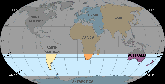
If we move southward below the equator we encounter an interesting range where there actually isn't much land, but if you do happen to live in this range, such as in Argentina or southern Australia, then the seasons of the year are actually reversed, with the shortest day of Winter occurring in June and the longest day of Summer occurring in December. This range extends from 23.5° South latitude, known as the "Tropic of Capricorn," down to 66.5° South latitude, known as the Antartic Circle. The "Tropic of Capricorn" is named after the zodiac constellation Capricorn, for reasons that will become apparent later on.
Notice how there's not much land down here in this region. Most people are familiar with the seasons of the year in the Northern Hemisphere and find it just a curious anomaly that there exist a few places on earth where the seasons are actually reversed.
As we head further South in this range the shortest day of the year gets shorter and shorter, and the longest day of the year gets longer and longer. The only difference is the shortest day of the year is in June, and the longest day of the year is in December. When we reach the antartic circle at 66.5° South latitude the shortest day of the year becomes so short the Sun actually never rises on that day, and the longest day of the year becomes so long the Sun actually never sets on that day.
If we continue further South, well no one lives down here, so who cares? Not even Santa Claus lives down here. Scientists seem to find the South Pole interesting though. They come down here during the summer, when it's light 24 hours a day, and perform all sorts of fascinating scientific experiments. Navigating around the South Pole is difficult though, because every direction is North. Compasses tend to point straight up. You can fly straight towards a pure white snow covered mountain and think you're looking at a faraway distant hazy horizon. (At the North Pole compass needles tend to point straight down, because hey, you're there! Actually the magnetic North Pole isn't quite in sync with the North Pole axis the earth rotates on.)
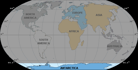
However, we are interested in the latitude of the Holy Land, which is around 25°-50° North, because this is the region where the Bible stories were written. Therefore all further discussion about the stars and the seasons of the year will be from this point of view.
Lesson 8: The Northern Hemisphere
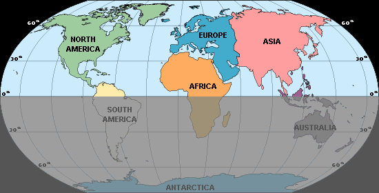
Note how most of the land of earth is above the equator, in the Northern Hemisphere. I have no explanation for why this is, but it probably explains why most maps of the world are oriented with the North side up. People don't like to look down on themselves.
The majority of land and hence the majority of the world's population is in the Northern Hemisphere, so we tend to orient world maps with North at the top.

This also explains why globes are oriented with the North Pole upwards, as this makes it easier to see most of the land. If a globe was mounted with the South Pole upwards then most of the land would be on the underside of the globe and we'd all be bending over to see the land.
People also like to place themselves in the center, so world maps made by Europeans place Europe in the center, as we have above, while world maps made by Americans place America in the center. Known as the cartographic "rule of ethnocentricity," the placement of one's own territory at the center of a world map is an almost-universal feature of cartographic devices, including cosmic diagrams of pre-Columbian North American Indians; ancient Babylonia, Greece, and China; and the medieval maps of the Islamic world or Christian Europe.
See The Map as Cultural Assumption. Louisiana State Museum.1996
See also The Four Main Centric Theories of the Universe below.
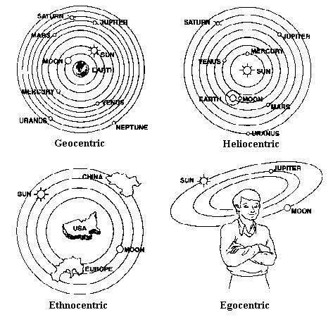
Source: From the book Science Made Stupid: How to Discomprehend the World Around Us by Tom Weller
Having most of the land in the Northern Hemisphere also explains why clocks go clockwise. Since most of the land is in the Northern Hemisphere, it's natural that the people who invented mechanical clocks would live in the Northern Hemisphere and would make the hands on their clocks mimic the direction a shadow moves on a sundial. "Clockwise" is the direction shadows move in the Northern Hemisphere. Most measuring devices with dials also go clockwise because of this.
See lesson on Sundials.
The convention of placing North at the top came a few centuries ago when European navigators started using the North star and the magnetic compass. Before that, the top of the map was to the East, which is where the word orient as in orientation comes from. The Chinese, however, put South at the tops of their maps, while Australians still like to refer to their country as "down under".
Other Links:
- The Map as Cultural Assumption
- The Upsidedown Map Page
- On maps, why is north always up?
- Maps and the History of Jerusalem
- Osher Map Library—Smith Center for Cartographic Education
- The Columbus Navigation Homepage
- Maps reflect people's cultural beliefs and perceptions Louisiana State Museum. 1996
All credit goes to my personal friends who allowed me to use their site to present this, for the mere sake of spreading knowledge.
Read it all here at
Imagine A World Without Superstitions
The Most Dangerous Superstition by Larken Rose (Free PDF download):
Learn To Win In Traffic Court in 30 Days!!!
Don't forget to comment with any questions or concerns you may have.
Grammar Nazis are welcome here. Help me help you.
This post recieved an upvote from minnowpond. If you would like to recieve upvotes from minnowpond on all your posts, simply FOLLOW @minnowpond
Congratulations @vidanatural! You have completed some achievement on Steemit and have been rewarded with new badge(s) :
Click on any badge to view your own Board of Honor on SteemitBoard.
For more information about SteemitBoard, click here
If you no longer want to receive notifications, reply to this comment with the word
STOPThis post recieved an upvote from minnowpond. If you would like to recieve upvotes from minnowpond on all your posts, simply FOLLOW @minnowpond