**IMPORTANT. 10% OF THE MONEY RECOLECTED WITH THIS POST WILL BE DONATED TO THE RED CROSS TO HELP THOSE AFFECTED BY HURRICANE IRMA.
SO PLEASE HELP AND SHARE!!**
The receipt of donations will be posted in the comments.
These days most of us heard about Huricane Irma, this means bad news for the world, knowing that effects of hurricanes have devastating effects most of the time. So today, in @HealthcaReport we wanted to pray for those affected, and to educate population as the best way to fight against this phenomenon.
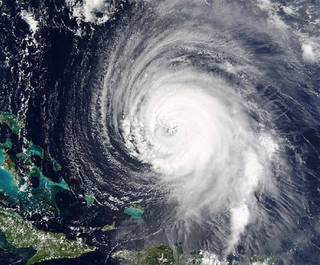
Image courtesy of NASA
FIRST OF ALL. WHAT HURRICANES ARE??
Hurricanes are large, swirling storms. They produce winds of 119 kilometers per hour (74 mph) or higher. That's faster than a cheetah, the fastest animal on land. Winds from a hurricane can damage buildings and trees.
Hurricanes form over warm ocean waters. Sometimes they strike land. When a hurricane reaches land, it pushes a wall of ocean water ashore. This wall of water is called a storm surge. Heavy rain and storm surge from a hurricane can cause flooding.
Once a hurricane forms, weather forecasters predict its path. They also predict how strong it will get. This information helps people get ready for the storm.
There are five types, or categories, of hurricanes. The scale of categories is called the Saffir-Simpson Hurricane Scale. The categories are based on wind speed.
Category 1: Winds 119-153 km/hr (74-95 mph) - faster than a cheetah.
Category 2: Winds 154-177 km/hr (96-110 mph) - as fast or faster than a baseball pitcher's fastball.
Category 3: Winds 178-208 km/hr (111-129 mph) - similar, or close, to the serving speed of many professional tennis players.
Category 4: Winds 209-251 km/hr (130-156 mph) - faster than the world's fastest rollercoaster.
Category 5: Winds more than 252 km/hr (157 mph) - similar, or close, to the speed of some high-speed trains.
WHAT ARE PARTS OF A HURRICANE
Eye: The eye is the "hole" at the center of the storm. Winds are light in this area. Skies are partly cloudy, and sometimes even clear.
Eye wall: The eye wall is a ring of thunderstorms. These storms swirl around the eye. The wall is where winds are strongest and rain is heaviest.
Rain bands: Bands of clouds and rain go far out from a hurricane's eye wall. These bands stretch for hundreds of miles. They contain thunderstorms and sometimes tornadoes.
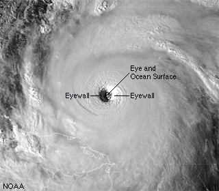
Image courtesy of unidata.ucar.edu
HOW ARE HURRICANES FORMED?
Hurricanes begin as tropical disturbances in warm ocean waters with surface temperatures of at least 80 degrees Fahrenheit (26.5 degrees Celsius). These low pressure systems are fed by energy from the warm seas. If a storm achieves wind speeds of 38 miles (61 kilometers) an hour, it becomes known as a tropical depression.
A tropical depression becomes a tropical storm–and is given a name–when its sustained wind speeds top 39 miles (63 kilometers) an hour. When a storm’s sustained wind speeds reach 74 miles (119 kilometers) an hour it becomes a hurricane and earns a category rating of 1 to 5 on the Saffir-Simpson scale.
HURRICANE IRMA . WHAT TO EXPECT?
Hurricane Irma, a potentially catastrophic Category 4 hurricane, is now hammering parts of the Bahamas and Cuba, and will turn its fury on Florida in what is likely to be the state's strongest hurricane strike since Charley 13 years ago.
Irma's Latest Status, Timing
The center of Irma is located about 315 miles southeast of Miami, Florida, and is moving west at about 12 mph.
Irma's maximum sustained winds are currently 155 mph, a formidably strong Category 4 hurricane, based on data from an Air Force Hurricane Hunter aircraft.
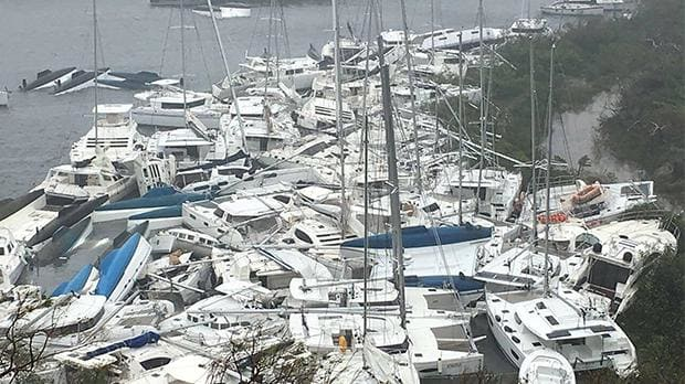
Image courtesy of The telegraph
COUNTRIES AND CITIES ALREADY AFFECTED BY IRMA
1-Antigua and Barbuda: About half of the island's 1,800 residents have been left homeless, and 90% of its buildings have suffered damage. Although gusts reached speeds of 230mph in Barbuda, the damage in Antigua has been described as "nominal, to the extent that it is business as usual".
2-St Martin, Anguilla and St Barts: Four people have died on the French side of St Martin, according to French Prime Minister Edouard Philippe.The Dutch Royal Navy said "enormous damage" had been caused on the Dutch side of the island, where at least one person died.
3-US Virgin Islands: Authorities said three people died after Irma caused what they called "catastrophic" damage.
4-British Virgin Islands: Sam Branson said on social media: "Glad to say that all humans on Necker are ok although a lot of buildings destroyed."
5-Puerto Rico: Four deaths were reported in Puerto Rico. Winds of 100mph left at least 900,000 people without power and nearly 50,000 without water.
6-Dominican Republic and Haiti: Irma's wind strength dipped to 175mph as she soaked the northern coasts of the Dominican Republic and Haiti on Thursday.
7-Turks and Caicos Islands: The hurricane hit this area early on Friday UK time bringing winds of around 175mph.
COUNTRIES AND CITIES POSSIBLY AFFECTED SOON
Bahamas: Friday-this weekend arriving from east to west; hurricane-force winds should spread into the northwest Bahamas by Saturday; slow improvement in the southeast Bahamas by Saturday
Cuba: Now through Saturday; conditions improving Sunday
Florida: Saturday-Sunday, lingering into early Monday in north Florida; hurricane-force winds may arrive in South Florida and the Florida Keys by Saturday night
Georgia-Carolinas: Late Sunday-Monday
WHAT TO DO IF YOU ARE EXPECTING A HURRICANE?
1-Gather Information
Know if you live in an evacuation area. Assess your risks and know your home's vulnerability to storm surge, flooding and wind. Understand National Weather Service forecast products and especially the meaning of NWS watches and warnings.
Contact your local National Weather Service office and local government/emergency management office. Find out what type of emergencies could occur and how you should respond.
Contacts
Keep a list of contact information for reference.
Image of Preparedness Checklist
Emergency Management Offices
County Law Enforcement
County Public Safety Fire/Rescue
State, County and City/Town Government
Local Hospitals
Local Utilities
Local American Red Cross
Local TV Stations
Local Radio Stations
Your Property Insurance Agent
Risk Analysis
Online hazard and vulnerability assessment tools are available to gather information about your risks.
Check your hazards risks with FEMA's Map Portal.
Rate your flood risk with the FloodSmart.gov portal.
2-Plan & Take Action
Everyone needs to be prepared for the unexpected. Your friends and family may not be together when disaster strikes. How will you find each other? Will you know if your children or parents are safe? You may have to evacuate or be confined to your home. What will you do if water, gas, electricity or phone services are shut off?
Supplies Kit
Put together a basic disaster supplies kit and consider storage locations for different situations. Help community members do the same.
Emergency Plans
Develop and document plans for your specific risks.
Protect yourself and family with a Family Emergency Plan
Be sure to plan for locations away from home
Pet owners should have plans to care for their animals. The Centers for Disease Control & Prevention offer information on animal health impacts in evacuation shelters.
Prepare your boat and be aware of marine safety if you are on or near the water.
Health & Environment
Follow guidelines to guard your community's health and protect the environment during and after the storm.
Review the Centers for Disease Control's (CDC) health considerations before, during, and after a storm.
Remember to follow the U.S. Food & Drug Administration's (FDA) food and water safety guidelines during disasters.
Review the Environmental Protection Agency (EPA) suggestions for health and environmental safety in disaster preparedness.
Evacuation
Image of Interstate Traffic in an Evacuation
Review the FEMA Evacuation Guidelines to allow for enough time to pack and inform friends and family if you need to leave your home. FOLLOW instructions issued by local officials. Leave immediately if ordered!
Consider your protection options to decide whether to stay or evacuate your home if you are not ordered to evacuate.
When waiting out a storm be careful, the danger may not be over yet...
Be alert for:
Tornadoes – they are often spawned by hurricanes.
The calm "eye" of the storm – it may seem like the storm is over, but after the eye passes, the winds will change direction and quickly return to hurricane force.
3-Recover
Wait until an area is declared safe before returning home.
Remember that recovering from a disaster is usually a gradual process.
Links of Interest & Source of Information:
1-NASA.com. What Are Hurricanes. Information recovered from: https://www.nasa.gov/audience/forstudents/k-4/stories/nasa-knows/what-are-hurricanes-k4.html
2-NationalGeographic.com. Hurricanes. Information recovered from: http://www.nationalgeographic.com/environment/natural-disasters/hurricanes/
3-Weather.com. Information recovered from: https://weather.com/storms/hurricane/news/hurricane-irma-bahamas-florida-georgia-carolinas-forecast
4-News.Sky.com. Hurricane Irma Path. Information recovered from: http://news.sky.com/story/hurricane-irma-path-what-countries-have-been-affected-11023725
5-National Hurricane Center. Ready. Information recovered from: http://www.nhc.noaa.gov/prepare/ready.php